Download
1 / 39
390 likes | 551 Vues
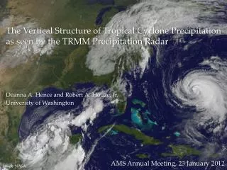
The use of radar in evaluating precipitation in LMK and ARPS: two precipitation cases over Belgium. 6 March 2007 International PhD-studens and Post-docs meeting on QPF. Kwinten Van Weverberg and Ingo Meirold-Mautner.

E N D
The use of radar in evaluating precipitation in LMK and ARPS: two precipitation cases over Belgium 6 March 2007 International PhD-studens and Post-docs meeting on QPF Kwinten Van Weverberg and Ingo Meirold-Mautner
Introduction Radar Model set up evaluation experiment preliminary conclusions Forecasting of precipitation is still one of the challinging tasks in Numerical Weather Prediction • Discontinuous distribution of water in space and time in the atmosphere in all its three phases. • Verification of model predicted precipitation variables is not straightforward. • We want to learn more about the strengths and weaknesses of both the LMK and ARPS model in simulating precipitation processes • A correct representation of precipitation in numerical models is indispensable for e.g. studying the sensitivity of precipitation processes to temperature changes
Introduction Radar Model set up evaluation experiment preliminary conclusions Until recently rain gauge measurements were the main input for evaluation of precipitation in atmospheric models • But rain gauges always have a too low spatial and temporal coverage and only provide us with ground precipitation data.
Introduction Radar Model set up evaluation experiment preliminary conclusions Precipitation radar Meteorological tower Satellite Vertical cloud profiler Microwave radiometer During the last two decades, new methods of remote measurement gained importance as alternative high quality data for hydrometeor model evaluation
Introduction Radar Model set up evaluation experiment preliminary conclusions Precipitation radar Meteorological tower Satellite Vertical cloud profiler Microwave radiometer During the last two decades, new methods of remote measurement gained importance as alternative high quality data for hydrometeor model evaluation
Introduction Radar Model set up evaluation experiment preliminary conclusions The C-band weather radar of the RMI in Wideumont • Radar sends electromagnetic pulse and receives the reflected pulse • The waiting time between sending and receiving is a measure for the distance of the target, the power of the returned beam is a measure for the size of the object • Radar scans in one direction on a turning platform (360°) and at different elevation angles (0.5 to 17.5°) to provide a full volume scan
Introduction Radar Model set up evaluation experiment preliminary conclusions The C-band weather radar of the RMI in Wideumont • C-band Doppler radar (3.7 – 4.2 GHz) • Positioned at a height of nearly 600 m in the south of Belgium • Radar beam scans each 5 min at 5 and each 15 min at 10 different elevation angles • Horizontal resolution is 250 m in range and 1 degree in azimuth
Introduction Radar Model set up evaluation experiment preliminary conclusions Advanced Regional prediction System (CAPS) Lokal Modell Kürzesfrist (DWD) • Mesoscale nonhydrostatic model • Subgrid scale turbulence: 1.5 order Turbulent Kinetic Energy closure • Kain and Fritsch convection parameterization in 9 km runs, no parameterization in 3 km runs. • Kessler warm rain microphysics scheme was used in the 9 km run, Lin-Tao 3-category ice scheme was used in the 3 km run • Initial and boundary conditations derived from ECMWF operational analysis • Double one-way nesting procedure • 9 and 3 km horizontal resolution Vertically stretched grid • 240 km x 240 km domain, covering Belgium • No data assimilation • Mesoscale nonhydrostatic model • Subgrid scale turbulence: 1 eq. Turbulent Kinetic Energy closure. • Moist convection following Tiedtke (1989) for shallow convection, no paramterization for deep convection • Grid scale clouds: saturation adjustment • Precipitation formation: bulk microphysics parameterization including water vapour, cloud water, rain and snow. • Initial and boundary conditations derived from ECMWF operational analysis • Double one-way nesting procedure • 7 and 2.8 km horizontal resolution • Vertically stretched grid • 500 km x 500 km domain, covering Belgium • No data assimilation
Introduction Radar Model set up evaluation experiment preliminary conclusions Advanced Regional prediction System (CAPS) Lokal Modell Kürzesfrist (DWD)
Introduction Radar Model set up evaluation experiment preliminary conclusions Two different cases were selected with each different precipitation characteristics... Frontal stratiform case convective supercell case 23/10/2006 01/10/2006
Introduction Radar Model set up evaluation experiment preliminary conclusions Two different cases were selected with each different precipitation characteristics... Frontal stratiform case convective supercell case 23/10/2006 01/10/2006
Introduction Radar Model set up evaluation experiment preliminary conclusions • An extensive model evaluation is necessary before using the model in experiments in order to gain insight in the model’s strengths and weaknesses in simulating the variables of interest • Using radar as a tool for atmospheric model evaluation has great advantages over the use of rain gauges due to the very high spatial and temporal coverage • We can also gain insight in the vertical distribution of hydrometeors and compare them to the modeled distribution
Introduction Radar Model set up evaluation experiment preliminary conclusions Model evaluation was done using the Wideumont radar • But... radar does not measure atmospheric constituents represented by the model, but measures only the reflectivities • Two approaches exist: observation to model Precipitation intensities are derived from radar reflectivities and compared to model precipitation intensities based on empirical relations Z = 200 x R1.6 (Marshall and Palmer) model to observation Radar reflectivity is derived from model variables and compared to observed radar reflectivities less uncertainty because model variables can be described much more accurately.
Introduction Radar Model set up evaluation experiment preliminary conclusions Model evaluation was done using a model to observation approach
Introduction Radar Model set up evaluation experiment preliminary conclusions Model evaluation was done using a model to observation approach Observation to model approach (preliminary results): comparing radar derived (Marshall and Palmer) and model precipitation fields 24h-Accumulated precipitation on 1 October 2006 LMK 2.8 km ARPS 9 km Radar 1 km
Introduction Radar Model set up evaluation experiment preliminary conclusions Model evaluation was done using a model to observation approach Observation to model approach (preliminary results): comparing radar derived (Marshall and Palmer) and model precipitation fields 24h-Accumulated precipitation on 23 October 2006 LMK 2.8 km ARPS 9 km Radar 1 km
Introduction Radar Model set up evaluation experiment preliminary conclusions Model evaluation was done using a model to observation approach But: large errors in the radar derived precipitation rates due to the Marshall Palmer relation, which is not constant in time.... Radar is prone to errors varying in time: attenuation, overshooting beam broadening. Further, the ZR relation depends on the hydrometeor type, which is not known
Introduction Radar Model set up evaluation experiment preliminary conclusions Model evaluation was done using a model to observation approach Model to observation approach (preliminary results): comparing radar reflectivities with simulated reflectivities based on model output. We do know the hydrometeor type in the model Simple forward operator (Keil et al, 2003), based on modeled formulas of Fovell and Ogura (1988) and the assumption of a Marshall-Palmer size distribution for the hydrometeors. Simple forward operator (Smedsmo et al, 2005)
Introduction Radar Model set up evaluation experiment preliminary conclusions Case 1: convective supercell (01/10/2006) Radar reflectivities at 2 km above the surface on 1 October 2006 at 15 UTC following Smedsmo (2005) LMK 2.8 km ARPS 9 km Radar 1 km
Introduction Radar Model set up evaluation experiment preliminary conclusions Case 1: convective supercell (01/10/2006) Mixing ratios of rain at 2 km above the surface on 1 October 2006 at 15 UTC LMK 2.8 km ARPS 9 km Radar 1 km
Introduction Radar Model set up evaluation experiment preliminary conclusions Case 1: convective supercell (01/10/2006) Vertical cross section through radar reflectivities (W-E) at 1 October 2006 at 15 UTC following Smedsmo et al (2005) LMK 2.8 km ARPS 9 km Radar 1 km
Introduction Radar Model set up evaluation experiment preliminary conclusions Case 1: convective supercell (01/10/2006) Vertical cross section through rain mixing ratio (W-E) at 1 October 2006 at 15 UTC LMK 2.8 km ARPS 9 km Radar 1 km
Introduction Radar Model set up evaluation experiment preliminary conclusions Case 1: convective supercell (01/10/2006) Spatially averaged vertical Profiles of Reflectivity at 1 October 2006 at 15 UTC ARPS 9 kmSmedsmo Radar 1 km
Introduction Radar Model set up evaluation experiment preliminary conclusions Case 2: stratiform case (23/10/2006) Radar reflectivities at 2 km above the surface on 23 October 2006 at 19 UTC following Smedsmo (2005) LMK 2.8 km ARPS 9 km Radar 1 km
Introduction Radar Model set up evaluation experiment preliminary conclusions Case 2: stratiform case (23/10/2006) Mixing ratios of rain at 2 km above the surface on 23 October 2006 at 19 UTC LMK 2.8 km ARPS 9 km Radar 1 km
Introduction Radar Model set up evaluation experiment preliminary conclusions Case 2: stratiform case (23/10/2006) Vertical cross section through radar reflectivities (W-E) at 23 October 2006 at 19 UTC following Smedsmo (2005) LMK 2.8 km ARPS 9 km Radar 1 km
Introduction Radar Model set up evaluation experiment preliminary conclusions Case 2: stratiform case (23/10/2006) Vertical cross section through rain mixing ratio (W-E) at 23 October 2006 at 19 UTC LMK 2.8 km ARPS 9 km Radar 1 km
Introduction Radar Model set up evaluation experiment preliminary conclusions Case 2: stratiform case (23/10/2006) Spatially averaged vertical Profiles of Reflectivity at 23 October 2006 at 19 UTC ARPS 9 km Smedsmo Radar 1 km
Introduction Radar Model set up evaluation experiment preliminary conclusions Model evaluation was done using a model to observation approach Model to observation approach (preliminary results): comparing radar reflectivities with simulated reflectivities based on model output. But a simple forward operator does not take the ‘errors’ in the radar observations into account (atmospheric refraction and attenuation) Advanced forward operator (Haase and Crewell, 2000), involving two steps: 1. simulation of the radar beam propagation including the effects of the Earth’s curvature and atmospheric refraction 2. determination of radar reflectivity and attenuation
Introduction Radar Model set up evaluation experiment preliminary conclusions Model evaluation was done using a model to observation approach • Once models are both having a satisfying set up, more advanced and quantitative evaluation techniques will be applied • Traditional verification Scores: False Alarm Ratio, Hit Rate, frequency bias, RMSE, Equitable Threat Score • Evolution Histograms • Categorical verification socres, discriminating between different sources of error: minimisation of RMSE (Hoffman et al. 1995 and Du et al. 2000), isolating individual precipiation events and minimising MSE (Ebert and McBride, 2000), allowing a distinction between errors due to displacement, volume and pattern error.
Introduction Radar Model set up evaluation experiment preliminary conclusions Preliminary conclusions • ARPS is clearly having a problem in simulating the convective storms. The amount of precipitation at the ground is more or less ok, but there are no reflectivities from the convective storms at all due to very low rain mixing ratios. ARPS is able to simulate the ground precipitation more or less, but the precipitating area is too large in the horizontal and extends to high into the atmosphere • LM captures the precipitation patterns for the convective case quite well, but tends to underestimate the ground precipitation amounts. The simulated reflectivities on the other hand are too high • The model set up needs to be much more improved for both models in order to start a more extensive evaluation, using the Radar Simulation Model and applying a forward operator (Radiative Transfer Model), e.g. The Cloudy RTTOV-6 (Chevalier et al, 2001) to investigate the model’s ability to simulate clouds.
Introduction Radar Model set up evaluation experiment preliminary conclusions Preliminary conclusions • ARPS is clearly having a problem in simulating the convective storms. The amount of precipitation at the ground is more or less ok, but there are no reflectivities from the convective storms at all due to very low rain mixing ratios. ARPS is able to simulate the ground precipitation more or less, but the precipitating area is too large in the horizontal and extends to high into the atmosphere • LM captures the precipitation patterns for the convective case quite well, but tends to underestimate the ground precipitation amounts. The simulated reflectivities on the other hand are too high • The model set up needs to be much more improved for both models in order to start a more extensive evaluation, using the Radar Simulation Model and applying a forward operator (Radiative Transfer Model), e.g. The Cloudy RTTOV-6 (Chevalier et al, 2001) to investigate the model’s ability to simulate clouds.
Introduction Radar Model set up evaluation experiment preliminary conclusions Preliminary conclusions • ARPS is clearly having a problem in simulating the convective storms. The amount of precipitation at the ground is more or less ok, but there are no reflectivities from the convective storms at all due to very low rain mixing ratios. ARPS is able to simulate the ground precipitation more or less, but the precipitating area is too large in the horizontal and extends to high into the atmosphere • LM captures the precipitation patterns for the convective case quite well, but tends to underestimate the ground precipitation amounts. The simulated reflectivities on the other hand are too high • The model set up needs to be much more improved for both models in order to start a more extensive evaluation, using the Radar Simulation Model and applying a forward operator (Radiative Transfer Model), e.g. The Cloudy RTTOV-6 (Chevalier et al, 2001) to investigate the model’s ability to simulate clouds.
Introduction Radar Model set up evaluation experiment preliminary conclusions prospectives • Both models will be improved testing the microphysics schemes, advection schemes, convection schemes and damping parameters. • ARPS will be run on a 3 km resolution, similar to the current LMK horizontal resolution • A more advanced forward operator will be applied (the Radar Simulation Model (Haase 2004)), a training at the SMHI is planned for the last week of March 2007 • Once both models seem to simulate both cases well enough, an extensive and much more quantitative model evaluation will be performed, also looking at the models’ ability to reproduce clouds • Advanced techniques will be applied for the precipitation verification, discriminating between the different sources of forecast error (Hoffman et al (1995), Du et al (2000), Nehrkorn et al (2003), Ebert and McBride (2000). • The most appropriate model with the most convenient model set up will be used in the furhter research to study the sensitivity of the precipitation characteristics to temperature increases in Belgium.
Introduction Radar Model set up evaluation experiment preliminary conclusions prospectives • Both models will be improved testing the microphysics schemes, advection schemes, convection schemes and damping parameters. • ARPS will be run on a 3 km resolution, similar to the current LMK horizontal resolution • A more advanced forward operator will be applied (the Radar Simulation Model (Haase 2004)), a training at the SMHI is planned for the last week of March 2007 • Once both models seem to simulate both cases well enough, an extensive and much more quantitative model evaluation will be performed, also looking at the models’ ability to reproduce clouds • Advanced techniques will be applied for the precipitation verification, discriminating between the different sources of forecast error (Hoffman et al (1995), Du et al (2000), Nehrkorn et al (2003), Ebert and McBride (2000). • The most appropriate model with the most convenient model set up will be used in the furhter research to study the sensitivity of the precipitation characteristics to temperature increases in Belgium.
Introduction Radar Model set up evaluation experiment preliminary conclusions prospectives • Both models will be improved testing the microphysics schemes, advection schemes, convection schemes and damping parameters. • ARPS will be run on a 3 km resolution, similar to the current LMK horizontal resolution • A more advanced forward operator will be applied (the Radar Simulation Model (Haase 2004)), a training at the SMHI is planned for the last week of March 2007 • Once both models seem to simulate both cases well enough, an extensive and much more quantitative model evaluation will be performed, also looking at the models’ ability to reproduce clouds • Advanced techniques will be applied for the precipitation verification, discriminating between the different sources of forecast error (Hoffman et al (1995), Du et al (2000), Nehrkorn et al (2003), Ebert and McBride (2000). • The most appropriate model with the most convenient model set up will be used in the furhter research to study the sensitivity of the precipitation characteristics to temperature increases in Belgium.
Introduction Radar Model set up evaluation experiment preliminary conclusions prospectives • Both models will be improved testing the microphysics schemes, advection schemes, convection schemes and damping parameters. • ARPS will be run on a 3 km resolution, similar to the current LMK horizontal resolution • A more advanced forward operator will be applied (the Radar Simulation Model (Haase 2004)), a training at the SMHI is planned for the last week of March 2007 • Once both models seem to simulate both cases well enough, an extensive and much more quantitative model evaluation will be performed, also looking at the models’ ability to reproduce clouds • Advanced techniques will be applied for the precipitation verification, discriminating between the different sources of forecast error (Hoffman et al (1995), Du et al (2000), Nehrkorn et al (2003), Ebert and McBride (2000). • The most appropriate model with the most convenient model set up will be used in the furhter research to study the sensitivity of the precipitation characteristics to temperature increases in Belgium.
Introduction Radar Model set up evaluation experiment preliminary conclusions prospectives • Both models will be improved testing the microphysics schemes, advection schemes, convection schemes and damping parameters. • ARPS will be run on a 3 km resolution, similar to the current LMK horizontal resolution • A more advanced forward operator will be applied (the Radar Simulation Model (Haase 2004)), a training at the SMHI is planned for the last week of March 2007 • Once both models seem to simulate both cases well enough, an extensive and much more quantitative model evaluation will be performed, also looking at the models’ ability to reproduce clouds • Advanced techniques will be applied for the precipitation verification, discriminating between the different sources of forecast error (Hoffman et al (1995), Du et al (2000), Nehrkorn et al (2003), Ebert and McBride (2000). • The most appropriate model with the most convenient model set up will be used in the furhter research to study the sensitivity of the precipitation characteristics to temperature increases in Belgium.
Introduction Radar Model set up evaluation experiment preliminary conclusions prospectives • Both models will be improved testing the microphysics schemes, advection schemes, convection schemes and damping parameters. • ARPS will be run on a 3 km resolution, similar to the current LMK horizontal resolution • A more advanced forward operator will be applied (the Radar Simulation Model (Haase 2004)), a training at the SMHI is planned for the last week of March 2007 • Once both models seem to simulate both cases well enough, an extensive and much more quantitative model evaluation will be performed, also looking at the models’ ability to reproduce clouds • Advanced techniques will be applied for the precipitation verification, discriminating between the different sources of forecast error (Hoffman et al (1995), Du et al (2000), Nehrkorn et al (2003), Ebert and McBride (2000). • The most appropriate model with the most convenient model set up will be used in the further research to study the sensitivity of the precipitation characteristics to temperature increases in Belgium.