Download
1 / 6
60 likes | 257 Vues
Integrating GIS with a Modified Universal Soil Loss Equation to Support Watershed Management. Paper by W. P. Gallimore and W. Xiang. 1991. Papers & Proceedings of Applied Geography Conferences, 14: 198-202. Presented by Kaylyn Siporin, Environmental Studies Major, GEOG 370, 2/26/08.

E N D
Integrating GIS with a Modified Universal Soil Loss Equation to Support Watershed Management Paper by W. P. Gallimore and W. Xiang. 1991.Papers & Proceedings of Applied Geography Conferences, 14: 198-202. Presented by Kaylyn Siporin, Environmental Studies Major, GEOG 370, 2/26/08
Use of Watershed Models • Problem • Watersheds are the basic unit for water quality management in an area. The evolution of ecological and environmental characteristics within a watershed are subject to natural processes and human activities. Few studies exist that use GIS to predict the future of watersheds. • Hypothesis • A basic GIS model of a watershed can assist in watershed management by producing future scenarios and impacts.
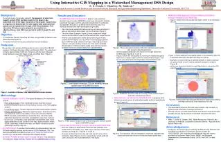
Properties of watersheds that relate to future management • Use of Arc/Info for the development of a watershed decision support system for the seven sub-basins of the Mountain Island Watershed in northern Mecklenburg County, North Carolina http://pix.epodunk.com/locatorMaps/nc/NC_216206.gif
Organization of Data • Data sources include USGS 7.5 minute topographic maps, the Mountain Island Conservancy, the Mecklenburg County EPA Office, and a private engineering firm • Data organization in three divisions: • Physical • Land Use • Environmental
Calculation of Potential Soil Loss • Measured the watershed’s potential for soil erosion with the Modified Universal Soil Loss Equation • PSL= R x K x LS x LUCC • Overlay was created by adding soil, slope, land use, and sub-basin together
Results • Future land use scenarios could be generated • Natural State Model vs. Maximum Build Model • The resulting scenarios defined the environmentally sensitive areas and provide information to better control future development