Download
1 / 35
350 likes | 468 Vues
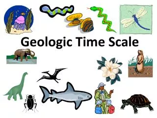
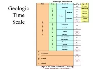
Chapter 4 - Modern Relative Time Scale. Early Mapping and Correlation of Stata Naming of rock strata becoming confused Local mining and mapping names Lateral continuity was becoming apparent with several different names referring to the same rock—a problem

E N D
Chapter 4 - Modern Relative Time Scale Early Mapping and Correlation of Stata Naming of rock strata becoming confused Local mining and mapping names Lateral continuity was becoming apparent with several different names referring to the same rock—a problem Jura Mountain rocks overlie German Tias rocks that in turn lay over the French Cretaceous strata Using superposition, the beginnings of
Early Mapping and Correlation of Strata Using superposition, the beginnings of a geologic time scale was in the process of formation Still many flood-centric scientists were convinced that the seemingly random boulders scattered across Europe were flood produced. Recognition of Agassiz’s theory of glaciation to account for the boulders tended to answer that problem
Modern Relative Time Scale Slow development of a new time scale based on stratigraphy (the study of rock layers and layering; strata) instead of strict biblical interpretation Adam Sedgwick and Roderick Murchison began to systematically name and formalize a geologic time scale of Europe (at least the “civilized northern part” of Europe.
Nothing Quite Like a Good Fight? Sedgwick, working (mapping) from the northwest towards the southeast in Silurian age rocks and Murchison working from the southeast towards the northwest mapping Cambrian rocks had both included rock strata into their own rock system. Where is the actual boundary? After not speaking to one another for years they compromised by splitting the disputed rocks into a new rock unit.
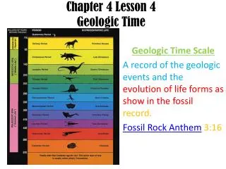
Rock Versus Time (End here) As geologic work progressed, it was becoming clear that there wasn’t a perfect correspondence of rock units with time. This is because of unconformities. The erosion and removal of older rocks or simply the lack of deposition of sediment for some reason. Geologists ideally should chose definitions based on the most complete (uninterrupted) rock sequence but because of the historical development of historical geology, this is seldom done. Start here
Corollaries to Superposition More Hutton Insights Detailed geological mapping through Scotland demonstrated additional relative dating principles. Principle of Cross-cutting Relationships: any igneous rock or fault must be younger than the rock that is cut. Principle of Included Fragments: any rock that contains included rocks must be younger than the rock that formed the inclusions.
The Formation Formation: the most basic local unit of stratigraphy. A distinctive series of strata that originated through the same “formative process”. (Environment of deposition). Must be distinctive in appearance so that it is easily identified in the field. Named for a type locality where it is well-exposed and (hopefully) complete
The Formation Problems Many practical problems with the definition. Defining upper and lower limits. Gradational environments. Not the same everywhere.
Additional Formation Characteristics Generally the definition includes: 1. Similar mineral grain composition. i.e., quarz sand 2. Color frequently indicates deposition environment 3. Textural properties grain roundness, sorting 4. Thickness and geometry of stratification 5. Character of organic remains coal 6. Outcrop character cliff-former
Lateral Variations It was widely assumed that the rock units seen in Europe would be seen in the rest of the world. The discovery of similar fossils throughout Europe encouraged this thought process. With continued geologic study, lateral variation in rock types was noted. Sedgwick and Murchison determined that the terrestrial Old Red Sandstone graded into the marine Devonian strata. Intertonguing: where two different lithologies (i.e., sandstone and shale) grade laterally into one another.
Depositional Environments and Sedimentary Facies Definition of sedimentary facies: “total aspect” of strata. All of the characteristics of the rock strata that include lateral variation, differences in lithology (rock type) and fossils. Relates the sediments in the rock to their depositional environment.
Transgression and Regression by the Sea Changes in sea level are important in determining many sedimentary processes. This can be seen in the sedimentary record by the recognition of intertonguing in many sedimentary rocks. Transgression: the rise of relative sea level by either eustatic (world-wide) sea level change or local tectonic changes (represented by rock folding and faulting). Regression: the retreat (drop) of sea from land.
Transgression by the Sea An important conclusion in the recognition of marine transgressions and regressions is that formations neither extend indefinitely laterally nor are everywhere of exactly the same age. Transgressive facies pattern: a characteristic pattern of sediment deposition that represents the rise of sea level (not just a single rock type; many rock types.) Grand Canyon example
Regression by the Sea Regressive facies pattern: a characteristic pattern of sediment deposition that represents the fall of sea level. Frequently contains unconformities since erosion usually only occurs above sea level. Grand Canyon example
Walther’s Law Johannes Walther, a German geologist, recognized that adjacent sedimentary environments succeed one another vertically. This means that the vertical progression of facies will be the same as corresponding lateral facies changes. These relationships are known as Walther’s Law.
Local Versus Worldwide Transgression and Regression Worldwide sea-level (eustatic) changes have been recognized. What causes them? Let’s look at what controls eustatic sea-level changes. Mid-latitude glaciation. Remove water from the oceans and lock up on land as a solid will reduce sea-level. Crustal depression and re-bound associated with mid-latitude glaciation.
Local Versus Worldwide Transgression and Regression continued The volume of the ocean basins is partially controlled by the speed of plate motion. This is because the new rocks formed at a divergent plate boundary, generally found in the oceans, are hot, and remain hot for tens of millions of years. This causes the warm crust to float higher on the asthenosphere, raise the ocean floor and reduce the volume of the ocean basin so that the oceans “spill out” over the continents.
Consequence of Eustatic Sea-level Changes Depending on the steepness of the coastline, the shoreline can dramatically move.
Consequence of Eustatic Sea-level Changes Advance of the Euphrates Delta.
Consequence of Eustatic Sea-level Changes Southern California Effects.
Biostratigraphic Concepts Generally geologists use fossil assemblages instead of just individual fossils for better control of age relationships.
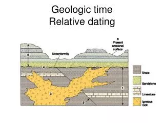
Unconformities Three types of unconformities. Nonconformity - sedimentary rocks that were deposited on eroded igneous or metamorphic rocks. These must represent erosion because igneous and metamorphic rocks formed deep underground. Disconformity - Sedimentary rocks deposited on parallel sedimentary rocks. Implies little tectonic change.
Unconformities Angluar unconformity - sedimentary rock that has been deposited on tilted sedimentary rocks. Implies a period of deposition, tectonic uplift and deformation followed by a fall in sea level and renewed deposition.
Unconformity-Bounded Sequences Six profound world-wide sequences of unconformities are recognized.