Download
1 / 29
380 likes | 873 Vues
THE LIMPOPO RIVER DRAINAGE BASIN. NINA, SOUMAIA & SEBASTIAN. The Limpopo Drainage Basin. Southern Africa 2 nd largest basin that drains in the Indian Ocean Region of water scarcity. Limpopo Drainage Basin. Limpopo Watershed. 15%. 20%. 21%. 44%. Facts.

E N D
THE LIMPOPO RIVER DRAINAGE BASIN NINA, SOUMAIA & SEBASTIAN
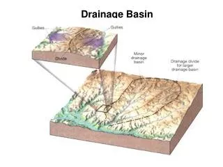
The Limpopo Drainage Basin • Southern Africa • 2nd largest basin that drains in the Indian Ocean • Region of water scarcity Limpopo Drainage Basin
Limpopo Watershed 15% 20% 21% 44%
Facts • Source: Northern slopes of Witwatersrand • Mouth: Indian Ocean at 25 to 15° South • Length: 1750 km • Navigable 160 km inland • Drainage area: 415,000 km² • Average rainfall: 530 mm per annum • Annual discharge: 174 288 m³/s at its mouth • Supports 14 million people • Population density in basin: 25-50 people per km² • One of the most densely populated basins in Africa • Use: Population and agriculture, mining and industries
Tributaries • Olifant River • Crocodile River • Notwane River • Bonwapitse River • Mahalapswe River • Matlabas River • Mokolo River • Lephalala River • Umzingwani River • Lotsane River • Motloutse River • Bubi River • Nzhelele River • Mwenezi River • Luvuhu River • Marico River • Shashe River • Mzingwane River
Climate • Tropical dry savannah and hot, dry steppe • Warm and cool temperate • Average evaporation: 1970 mm/year → higher evaporation rate than rainfall • 95% of rainfall between October and April → time of floods • Short and intense rainy season • Frequent droughts • Deforestation in South Africa → increased soil erosion and surface runoff → Flooding in Limpopo Drainage Basin
Long profile • Upper course: part of the continental plateau, arid climate in the Kalahari Desert • Middle course: Waterberg Biosphere Reserve, 15000 km², low population density • Lower course: Width of 300m, wide coastal plain, obstructed by sandbanks, swampy region, takes up much water in rainy season, fertile soil, heavily populated
Problems of Limpopo River • Water scarcity – A threat to the population (Droughts, short and intense rainy seasons) → Provide water for all riparian states • Urbanization and tourism → areas cleared for agriculture • Salinity → salt water intrusion at high tide at rivers mouth affects quality of irrigation water → Water quality
Spreads diseases • Cholera → Limpopo tested positive for Cholera in December 2008 • Spreading of various diseases • Affecting many people and countries • Leading to illness and death
Limpopo and floods • Causes of flood: Heavy rain over frontier area of Mozambique and South Africa • Consequences : • Death • Lost agriculture and land • Destroyed roads, railways • Livestock and crops lost • Short of drinking and sanitation water
Limpopo Flood Control • UN-South Africa project • Development of a full hydrodynamic model of the river system. • The Department for Combating Natural Disaster(Mozambique 1977) • National Disaster Management Institute • CPWF (Challenge Program on Water and Food) → improve food security and maximise the use of water
ACTIVITIES ON LIMPOPOINTRODUCTION • The Limpopo River Basin constitutes a major economic hub for the SADC region. Economic activities such as agriculture, mining, tourism and manufacturing are undertaken within the basin.
Water Demand • The Limpopo river is an important source of surface water for economic development in all four riparian states. There is a relatively high population density, major towns exist in the basin, development of a large number of dams to service industries, agriculture and mines. • Water Supply :It offers a wide spectrum of shared aquifers. The alluvial aquifers associated with the Limpopo river and its tributaries are of particular importance in areas where river flow is not permanent. • In the basin there are at least 13 dams with a storage capacity exceeding one cu km – 1 in Moz., 8 in SA, 3 in Zim. and 1 in Bot. Largest is Massingir dam in Mozambique whose present capacity is estimated at 1.2 cu km.
SA has 198,000 ha under irrigation; Moz irrigates 40,000 ha; Zim has 3,992 ha; Bot 1,381 ha under irrigation in the basin • CountryIrrigation Potential (Ha) :Bot- 15 208; Moz- 148 000; SA -131 500 Zim-10 900ha. • Livestock is the principal form of economic activity in most parts of the basin, especially upstream Limpopo area, though its nature and degree of importance varies greatly. In the rural areas, rearing of small stock is quite important in all the basin countries except for South Africa.
ENERGY • The basin relies on COAL-FIRED THERMAL power stations and on HYDROELECTRICITY generated from a few major reservoirs outside the river basin for its energy. Majority of rural communities use FIREWOOD
Manufacturing Industry • Upper Limpopo: --have well developed manufacturing and service. In SA, manufacturing is more diversified than in Botswana --Botswana is mainly primary –mines, sec- processing of mine products supported by a well-developed infrastructure, including a good road and rail network. • Middle and Lower Limpopo: no significant manufacturing except in Bulawayo- food processing, leather tanning, textiles and steel fabrication.
TOURISM • one of the fastest growing industries on Limpopo basin and major GDP contributor • Large and well-managed parks such as Kruger in South Africa and Gonarezhou in Zimbabwe which attract a lot of tourists • Beaches at the mouth of Limpopo attracts visitors from South Africa
OTHER ECONOMIC ACTIVITIES • Numerous and contribution in the GDPs of the 4 riparian states cannot be ignored. These include: • Fishing- mainly by communities for subsistence, although lately increased fish trade is taking place within and outside boundaries of the Limpopo river basin. • Ltd amount of commercial forestry in the basin, particularly in parts of SA and Moz.
Suitable climatic conditions for large-scale commercial forestry occur in SA in the Highveld where plantations are generally confined to the high rainfall belt along the eastern escarpment of the Drakensburg mountains and in northern Mpumalanga. • The rest of the Limpopo basin is climatically unsuitable for commercial production of exotic forest species.
Quick facts about the flood • It was a natural disaster that occurred in February and March 2000. • was caused by heavy rainfall that lasted for five weeks • Approximately 800 people were killed. • 1,400 km² of arable land was affected and • 20,000 head of cattle were lost. It was the worst flood in the Mozambique in 50 yrs
DEVELOPMENT OF THE FLOOD • The floods began on 9 February with high levels of precipitation across Southern Africa, South Africa, southern Botswana and Swaziland were also affected • Torrential rain continued to the 11th of February, in Mozambique's Limpopo Valley, the banks of the Limpopo River burst(BFD exceeded), causing severe flood damage; • EFFECTS: residents of the area are struck with dysentery.
On 22 February, tropical Cyclone Eline hit the Mozambique coast near Beira, north of the areas already affected by flooding • On February 27, flash floods inundated low farmlands around Chokwe and Xai-Xai
MODIFICATION OF VULNERABILITY OF FLOOD • Over 45,000 people were rescued from rooftops, trees, and other isolated areas. This effort was at first carried out by only a few Mozambican naval vessels. • The governments of South Africa, Malawi, and Mozambique provided fewer than a dozen helicopters to the rescue effort
DAMAGES CAUSED AFTER FLOOD SUBSIDED • In early March, the Red Cross reported that more than 250,000 acres of farm fields, including one-third of the year's staple corn crop, had washed away. Massive erosion. The floods subsided after a week or more, • Towns, roads, and bridges demolished. • Worries of malaria and water-borne diseases also increased in the aftermath of the floods
longer-term consequence : increased international aid for damming these rivers that will help control floods in the future.. • Unknown numbers of people, as well as tens of thousands of cattle, drowned. • In an impoverished country with a large population of peasant farmers, such destruction is very difficult to cope with
90% of the Mozambique's functioning irrigation infrastructure was damaged, causing the worst of the agriculture losses suffered. • 1,400 Km² of cultivated and grazing land was lost, leaving 113,000 small farming households with nothing. • 630 schools were closed leaving 214,000 students and teachers without classrooms. • 42 health units were destroyed, including Beira Central Hospital, the second largest in the country.
THE END Gracias, takk