Download
1 / 18
270 likes | 527 Vues
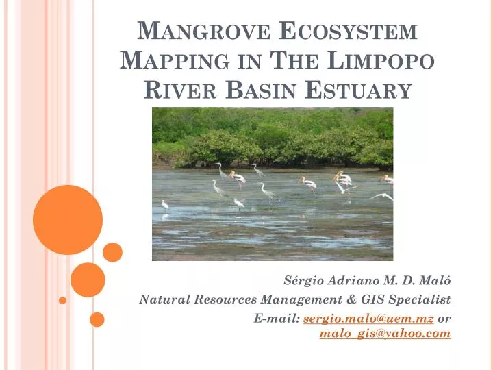
Mangrove Ecosystem Mapping in The Limpopo River Basin Estuary. S érgio Adriano M. D. Maló Natural Resources Management & GIS Specialist E-mail: sergio.malo@uem.mz or malo_gis@yahoo.com. Presentation Contents. Introduction and background Study area Objectives Methods

E N D
Mangrove Ecosystem Mapping in The Limpopo River Basin Estuary Sérgio Adriano M. D. Maló Natural Resources Management & GIS Specialist E-mail: sergio.malo@uem.mz or malo_gis@yahoo.com
Presentation Contents • Introduction and background • Study area • Objectives • Methods • Limpopo river estuary land use and cover • Mangrove degradetion factors • Mangrove ecosystem use and impact on community livelihood • Final remarks
Introduction and background • Mangroves are highly productive, biodiversity rich forest ecosystems adapted to survive in the harsh interface between land and sea. • Products and eco-services: timber, fire wood, construction materials, habitat for fisheries, coast lines protection from tsunamis, storm surges and erosion; carbon sequestration. • An estimated 35 600 k m2 were lost between 1980 and 2005, and the annual rate of loss between 2000 and 2005 was 0.66%. • Climate change will may affect mangroves: changes in sea-level and high water events (floods).
Introduction and background • The Limpopo river estuary mangrove is proved to be vulnerable to extreme weather events (floods) and most likely to be affected by expected climate change impact. • The mangrove have been destroyed by the 2000 floods and very poor regeneration is been observed. • José (2009) and Balidy et al (2005) suggests as possible causes: the change in the structure and composition of the substrate and hydrological system conditions.
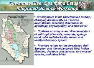
Study area • The Limpopo river basin catchment lies over 416,000 Km² and has over 14 million residents living in it. • The study area: from the Limpopo month up to Lumane and Limpopo rivers junction: 24 de Julho, Zimilene and Salvador Allende communities. Total population: 17,212 residents according to 2007 census.
Objectives • Over all objective: • To do the mangrove ecosystem mapping for better understanding of their lose area and their potential impacts on local communities livelihood, particularly those located in surrounding areas of mangrove forest as well as identify the ecosystem degradation factors. • Specific objectives: • Analyse the Limpopo river estuary land use and cover pattern • To identify the mangrove degradetion factors • To identity the impact of mangrove ecosystem use on local community livelihood
Methods 2003 2010 • Literature review • Environmental history approach (key informants and RS) • Remote sensing (RS) and Geographical Information System (GIS) • Google Earth images of the study area were used to detect changes in land use and land cover between 2003 and 2010 (08/09/2003 and 21/02/2010). • The visual interpretation technique. • Interviews: key informants and environmental experts. • Field visits (Focus groups discussion and participatory mapping).
Limpopo river estuary land use and cover 2003 2010 • Mangrove degradeted: 1,102.44 (2003) to 1,114.55 (2010) difference: -12.11 • Mangrove in good condition: 200.24 (2003) to 188.13 (2010) difference: 12.11
Mangrove degradation factors • 1) Decreasing of water and solid (mud/clay) flows; • 2) During the 2000 floods the mangrove and the estuary area was overwhelmed by a large volume of sediment that altered soil conditions for the mangrove development (IUCN & MICOA, 2011); • 3) Expected climate change impact Vs anthropogenic use; • 4) It is important do consider local people involvement on mangrove conservation measures.
Mangrove ecosystem use and impact on community livelihood • The livelihood assets that support both adaptative capacity and resilience are: • Natural • Physical • Financial • Social
Mangrove ecosystem use and impact on community livelihood • Natural assets: • Terrestrial land: agriculture, livestock (7,442.36) and Human settlements use. • The land supports subsistence agriculture (rice and maize); • Around 1,302.68 hectares of mangrove forestry • Benefits from mangrove including disaster reduction , protection of agricultural land trough the salt absorption and potential for aquaculture and carbon sequestration exploration. • Only 188,13 hec of mangrove is in good condition and around 1,114.55 degradated • Len of Limpopo River and tributaries (Lumane River).
Mangrove ecosystem use and impact on community livelihood • Physical assets: • Road access to the main roads trough an unpaved road that provides connection to the markets, • This road is difficult to use in rain season and this is a limitation for this region. • The study area has a primary school facility that is a potential for economic mobility trough education. • In Chilaulene (Salvador Allende) village there is a heath facility that provide a basic health care services.
Mangrove ecosystem use and impact on community livelihood • Financial assets: • There is no bank or formal credit system that can provide investment opportunities in diversifying the income generation activities. • Opportunities for fish market and aquaculture
Mangrove ecosystem use and impact on community livelihood Social assets: • The CDS-ZC is enabling the environment for community associations for mangrove conservation activities trough a Community Based Conservation initiative. • CDS-ZC is implementing mangrove restoration activity with collaboration of the local community. • This will create opportunity to respond to changes with collaborative actions as well as channels for information dissemination and awareness raising.
Final remarks • Mangrove degradeted: 1,102.44 (2003) to 1,114.55 (2010) difference: -12.11 • Mangrove in good condition: 200.24 (2003) to 188.13 (2010) difference: 12.11 • The Zongoene local community recognizes the mangrove conservation importance • The linkage with their natural livelihood assets that mangroves provides. • Degradetions factores: • Natural: floods; poor generation rate (soils conditions); human actions (timber and firewood); climate change?
Final remarks • The mangrove ecosystem and surrounding wetlands supports around 17,212 inhabitants. • The livelihood assets that support both adaptative capacity and resilience are: Natural assets; Physical assets; Financial assets and Social assets • If the mangrove is not there, there will be less agriculture land for crop production due to soils salinization trough a salt intrusion process that is already taking place.
Thank you Let us protect the nature