Download
1 / 22
220 likes | 312 Vues
Hydrological Data and Modelling Azizan Abu Samah Ramani Bai Ilya Zaslavsky Ghasem Akbari. Focus 1: integrated hydrologic data. Collecting, organizing, describing and making data accessible in a consistent form suitable for visualization, analysis and modeling – is an important direction

E N D
Hydrological Data and ModellingAzizan Abu SamahRamaniBaiIlya ZaslavskyGhasemAkbari
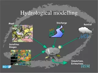
Focus 1: integrated hydrologic data • Collecting, organizing, describing and making data accessible in a consistent form suitable for visualization, analysis and modeling – is an important direction • Having the first integrated database of hydrologic observations and related data, could be a project deliverable • Such that partners can contribute their datasets • Such that these data can be discovered and queried in a standard manner • Such that the data can be easier interfaced with models • Related to governance (“data governance”), cultural (local metadata and query types), and other teams • Create a persistent data infrastructure for this and other projects in the area: to ease model calibration and customization, reduce duplication in data collection • Can be other uses besides modeling: visualization and trends analysis, public engagement and partnerships, comparisons, etc…
Focus 2: integrated hydrologic models • Conceptual models, related to governance, water cycle; then populating them for different cities • Macro-scale: simulation of water balance and water management policies under different climate change scenarios, e.g. • Water saving strategies (for areas with water shortage); • Water regulation and consumption strategies (for flood-prone areas); • Potential socio-economic impacts and behavioral responses to increase in water rates and fees, water rationing, zoning changes, etc, under global climate change scenarios. • Micro-scale: spatially-disaggregated modeling to help develop better water management decisions in specific watersheds. The HEC-GeoHMS modeling system will be the main tool in this group of models. Potential questions that can be addressed by HEC-HMS modeling: • Characterize impact of flooding • Predict severity of urban flooding events and their probability under different development scenarios, evaluate mitigating land use control and hydrotechnical measures • Predict flood frequencies, and design water control measures • Optimal planning to reduce flood damage for selected watersheds • Identify flood-prone areas where a flood warning system would be critical in reducing mitigation time
Macro-scale modeling: can be done using Stella or similar, published on the web. We expect that the core water balance model will be uniform across cities, calibrated for each city Example wetland and flood extent model for Dong Nai river, Vietnam: experiment with runoff and outflow coefficients
Micro-scale modeling: can be done using HEC-HMS and GeoHMS Requires detailed GIS data: • - Hydrologic Elements including, basin and sub-basin boundary delineation, stream network, river length, river slope (Topo maps, satellite image derived DEM, 10m) • - Basin slope (DEM, 10 m) • - Land use (Satellite image, 10m) • - Soil map (Soil survey map 1:10,000 or 1:25000 0r 1:50,000) • - Channel geometry, channel roughness (need some field work) • Rainfall distribution (rain gauges, TRMM data, radar, proxy NCEP OLR (5-10 km grid)) • Hydrologic gages (discharge, gage height – need to assemble from local data) Issues: software costs; lack of data for modeling(need to establish partnerships with data holders, and estimate data from remote sensing) build local expertise and capacity for data collection, data management and modeling
Strategy • create a comprehensive suite of data management and data estimation tools and procedures, and develop models initially for relatively data-rich areas (San Diego, Singapore, Kuala Lumpur). • At the same time, work on creating a consistent data sharing infrastructure and local capacity building to ensure that these tools and models can be extended to and re-used in other cities. • We believe that activities in these two areas shall be conducted in an integrated manner, so that • (a) the requirements and constraints of the data-poor areas will be taken into account from the start of the project, and • (b) local capacity will be created for successful expansion of data management and hydrologic modeling tools to these areas.
Research Challenges • Procedures and tools for estimating missing data from available data; • Improving spatial resolution of GeoHMS inputs by combining several datasets (e.g. TRMM and local gages); • Creating a common information management system, by leveraging established standards for hydrologic data exchange; • Adapting emerging standards for water data exchange to different socio-economic and cultural contexts, and local data collection practices; • Hydrologic modeling at the urban-rural critical zone; • Setting up continuous hydrologic observatories in critical areas (and identifying these critical areas through modeling); • Understanding and modeling socio-economic and behavioral responses to water events and management decisions • Integrating water quality information into modeling
What can be done soon • Workshops, with sufficient hands-on component, to build local capacity in hydrologic observatory management, hydrologic information management, and modeling (needed: travel; workshop funding, preparation materials, tutorials, developing training data for study areas; 50-70K) • Create a forum and an online portal where participants from the study cities can share information (2 months developer time; we also need one representative from each city to be trained to use and update the portal. Work on the portal started; 40-50K) • Create a common data infrastructure where hydrologic observation data can be published and exchanged between study cities (workshop training; grad students visiting San Diego for training in HIS; mentoring support; web development for the portal (6 months developer, building on HIS project) (120-150K) • Create a macro-simulation of water balance, publish it online, calibrate for participating cities, and build curriculum materials around it (6 months developer; 3 months data collection, plus exchange of graduate students) (120K) • Assimilation of TRMM data for study cities, and transforming TRMM into GeoHMS inputs (6 months researcher, 1 year graduate student) (120K) • Calibrating GeoHMS for Kuala Lumpur, as the first step (100K) • Acquisition of DEMs and transformation into GeoHMS inputs (???) • So far: 550-610K, 1.5-2 years
What has been started - 1 • GeoHMS modeling well underway in the Kuala Lumpur area Spatial Data Updating Using Enhanced Satellite Image A. Akbari1,. Azizan Abu Samah2 , V.Ramani Bai3 1,3Department of Civil Engineering, University of Malaya, 50603 Kuala Lumpur, Malaysia 2Department of geography, University of Malaya, 50603 Kuala Lumpur, Malaysia Email: akbari_gis@yahoo.com
Spatial variability of Storms over the Urbanized River Basin, Case Study, upper Klang River Basin, Malaysia
Figure 14: Kriging interpolation for Storm event of 21 Dec 2002 based on Exponential semi-variogram model Kriging interpolation for Storm event of 21 Dec 2002 based on Gaussian semi-variogram model Kriging interpolation for Storm event of 21 Dec 2002 based on Spherical semi-variogram model
What has been started - 2 • Project web portal created (i.e. participants can edit content remotely, upload data, etc.). Currently the web site hosts project description, some documents, links to data and modeling resources, news feeds, a wiki. (http://spatial.sdsc.edu/lab/tabid/70/Default.aspx)
What has been started - 3 • TRMM investigated as possible source of precipitation data (http://river.sdsc.edu/wiki/TRMM%20notes.ashx.) • The most appropriate TRMM source is NASA organized data available as 3hr precipitation grids at .25x.25 degree spatial resolution. We need to see if Malaysian rain gage archive can be used to calibrate the data for better spatial resolution (and need to obtain this archive) • These data can be made available via WaterML web services (as elsewhere in the CUAHSI HIS project, which will be leveraged for the data management part)
Workshop in Kuala Lumpur, July’09 • Topic 1: Hydrologic data management • Topic 2: Hydrologic modeling • Hands-on, 2-3 days, plus field trip • Partners are welcome • Encouraged to bring their data (observations by stations, DEMs, etc.) – lists and templates will be provided • Also planning in one additional partner city
Discussion after the talk • Modeling shall be embedded in decision-making context, so that results are valued • Need to connect with the governance group • Need to gather requirements • Need big picture (conceptual) modeling • Incorporating water supply and demand trends and development policies • Incorporate water quality and groundwater • Model water cycle, customized for different cities; evaluate water security • Data and models must integrate uncertainty measures; deal with data gaps and QA/QC; the infrastructure for modeling must allow use of most recent independently updated data • Must be aware of data available through multiple international programs for Asia • Make sure that calibrated models can be extrapolated to climate change scenarios
Hydrologic Data Management for CMAS Ilya Zaslavsky, UCSD CUAHSI HIS: NSF support through 2012 (GEO), ~10 mil invested Partners: Academic: 11 NSF hydrologic observatories, CEO:P projects, LTER… Government: USGS, EPA, NCDC, NWS, state and local Commercial: Microsoft, ESRI, Kisters International: Australia, UK Standardization: OGC, WMO (Hydrology Domain WG, CHy); adopted by USGS, NCDC An online distributed system to support the sharing of hydrologic data from multiple repositories and databases via standard water data service protocols; software for data publication, discovery, access and integration.
Integration of Disparate Data Deployment All accessible through standard WaterML interface. Currently over 1.75 mil stations, servers in US and Australia. Free software
HIS in CMAS • Premise: • Having a consistent data infrastructure for modeling across city will make it easier to calibrate and customize models, compare results, will support a variety of other analysis, visualization and modeling efforts, reduce duplication in data collection, support partnerships • Plans: • Capacity building workshops (first hands-on workshop is planned in Malaysia in July, have seed funding) • Setting up HIS Servers to help publish local hydrologic data + training • Create an online forum for hydrologic modeling in tropical areas • Analyze hydrologic data availability for study cities; calibrate available remote sensing data for use as Geo-HMS inputs • Adjust data protocols, validate standards and ontologies based on local context • To date: • Project web portal partly built (participants can edit content, upload data, use wiki, etc.). Currently has documents, links to data and modeling resources, news feeds, etc. • TRMM investigated as possible source of precipitation data (http://river.sdsc.edu/wiki/TRMM%20notes.ashx.)