Download
1 / 18
210 likes | 569 Vues
Jason-1 Altimeter. Calen Carabajal. Overview of Jason-1 Mission. Launched December 7 th 2001 by CNES and NASA at Vanderberg AFB, CA Successor of the Topex /Poseidon satellite mission (1992-2006)

E N D
Jason-1 Altimeter Calen Carabajal
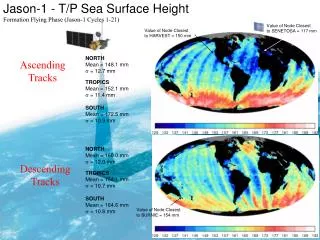
Overview of Jason-1 Mission • Launched December 7th2001 by CNES and NASA at Vanderberg AFB, CA • Successor of the Topex/Poseidon satellite mission (1992-2006) • Was placed in same nominal orbit with a delay of one minute for measurement comparison, then in tandem • Goal: Ocean surface topography • Sea level changes on yearly basis • Ocean models • Weather forecasting
Jason-1 Satellite • Proteus platform • Reusable and adaptable spacecraft bus • Altitude: 1336 km • Inclination: 66° • Mass: 1100 lbs(500 kg) • Orbital period: 6754 seconds (~112 minutes) • Cycle: 10 days • Passes per cycle: 254 Proteus platform
Jason-1 Instruments • Jason-1 has five instruments • Poseidon-2 Altimeter • Jason-1 Microwave Radiometer (JMR) • Location Systems • Doppler Orbitography and Positioning Integrated by Satellite (DORIS) • Turbo Rogue Space Receiver (TRSR) • Laser Retroreflector Array
Jason-1 Microwave Radiometer • Three operating frequencies • 18.7 GHz • Wind-induced effects • 23.8 GHz • Water vapor • 34.0 GHz • Liquid water content of clouds • All measurements used to determine phase delay from water vapor, affected by ocean salinity, foam, temperature.
Location Systems • DORIS • Precise Orbit Determination (POD) • Complements dual-frequency operation of Poseidon-2 • Transmits 2- and 0.4-GHz signal • Uses orbit-determination models and keeps track of orbit • LRA • Calibration of POD • Passive reflector • TRSR • Supplementary position data • Degraded performance since 2009 LRA DORIS TRSR
Poseidon-2 Altimeter System • Derived from Poseidon-1 (TOPEX/Poseidon) • Dual-frequency altimeterwith Ku- and C-band frequencies • Also referred to as the Solid-State Altimeter, SSALT • Capable of altimetry, , wave height, ionospheric correction measurements
Poseidon-2 Altimeter Specifications • Ku-band frequency balances power capabilities, bandwidth, and atmospheric perturbation • C-band frequency accounts for ionospheric delay correction • Uses full-deramp technique • Interlaced pulses • Mass: 50 kg
Surface Effects Epoch
References • Aviso. http://www.aviso.oceanobs.com/en/ • http://www.aviso.oceanobs.com/fileadmin/documents/calval/validation_report/J1/BilanCalval_J1_Cycle_524.pdf • Radar Altimetry Tutorial. http://www.altimetry.info/ • http://www.altimetry.info/html/missions/jason1/ • Ocean Surface Topography from Space. http://sealevel.jpl.nasa.gov