Download
1 / 9
100 likes | 325 Vues
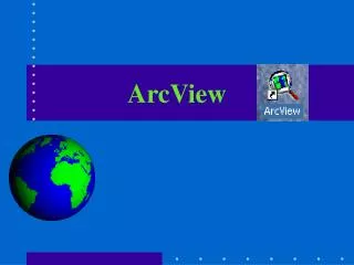
ArcView, ArcGIS. Yulia Kim. ArcView is full-featured GIS software for visualizing, analyzing, creating, and managing data with geographic component.

E N D
ArcView, ArcGIS Yulia Kim
ArcView is full-featured GIS software for visualizing, analyzing, creating, and managing data with geographic component. • Most data has a component that can be tied to a place: an address, postal code, global positioning system location, census block, city, region, country, or other location. • ArcView allows you to visualize, explore, and analyze this data, revealing patterns, relationships, and trends that are not readily apparent in databases, spreadsheets, or statistical packages. • ArcView is used by people around the world in a wide range of industries and applications. • ArcView helps thousands of organizations understand spatial relationships in data so they may make better decisions and solve problems faster. ArcView is used by people around the world in a wide range of industries and applications.
1. Ease of Use ArcView is the most widely used desktop GIS software in the world because it provides an easy way for everyone to use geographic data. 2. Data Visualization With ArcView, you can build compelling maps that help you visualize patterns, trends, and exceptions in your data. ArcView includes simple wizards, predefined map templates, and an extensive suite of map elements that save you time and make it easy to create professional-quality maps. Completed maps can be saved, printed, exported, and embedded in other documents or applications. ArcView also allows you to visualize your data as charts and reports, in 3D, and over time.
3. Spatial Analysis ArcView allows you to better answer questions, test theories or predictions, and examine relationships. ArcView includes tools and procedures that allow you to analyze spatial data and derive answers from data of a location-dependent nature. Like all the ArcGIS Desktop products, ArcView software's rich geoprocessing framework includes ready-to-use analysis tools as well as the ability to build process models, scripts, and complete workflows. 4. Data Management ArcView makes it easy to integrate all types of data for visualization and analysis. It includes a number of tools for geographic, tabular, and metadata management, creation, and organization. ArcView supports a wide variety of data types including demographics, facilities, CAD drawings, imagery, Web services, and multimedia. You can directly read or import more than 70 different formats with ArcView.
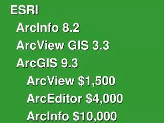
5. Ready-to-Use Datasets • ArcView includes the ESRI Data and Maps Media Kit, which is updated annually and preconfigured to work with ESRI's software. • The ESRI Data and Maps Media Kit includes • Basemap and thematic MXDs for Canada, Europe, Mexico, and the United States • Commercial data from Tele Atlas, AND Mapping, DMTI Spatial, WorldSat, EarthSat, DigitalGlobe, EuroGeographics, Michael Bauer Research, CountryWatch, SIGSA, and ESRI • All levels of U.S. census geography and ZIP Codes • TIGER 2000-based StreetMap USA data • Global natural view image • More than 15 GB of data
ArcGIS is an integrated collection of GIS software products for building a complete GIS. • ArcGIS enables users • to deploy GIS functionality • wherever it is needed — • in desktops, servers, • or custom applications; • over the Web; • or in the field. • ArcGIS Framework
1. Geodatabase Technology • Like all information systems, ArcGIS has a well-defined model for working with data—the geodatabase. • A common framework shared by all ArcGIS products and applications, the geodatabase allows you to • Handle rich data types. • Apply sophisticated rules and relationships. • Access large volumes of geographic data stored in files and databases. • More than a manager of geographic data, the geodatabase also implements sophisticated business logic that, for example, builds relationships between data types such as topologies and geometric networks, validates data, and controls access.
Agenda 1. Ease of Use 2. Data Visualization 3. Spatial Analysis 4. Data Management 4. Data Management