Download
1 / 15
210 likes | 521 Vues
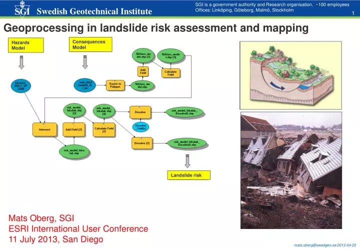
SGI is a government authority and Research organisation, ~100 employees Offices: Linköping, Göteborg, Malmö, Stockholm. Geoprocessing in landslide risk assessment and mapping. Consequences Model. Hazards Model. Landslide risk. Mats Oberg, SGI ESRI International User Conference

E N D
SGI is a government authority and Research organisation, ~100 employees Offices: Linköping, Göteborg, Malmö, Stockholm Geoprocessing in landslide risk assessment and mapping Consequences Model Hazards Model Landslide risk Mats Oberg, SGI ESRI International User Conference 11 July 2013, San Diego
Causes for landslides • Risk = Probability of Hazard * Consequences • ArcGIS for modelling and map production (Model Builder, Spatial Analyst, Data driven pages) in a 3 year project in Gota river valley, Sweden Gota river valley, Sweden
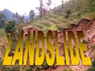
Occurred landslides in Sweden Surte 1950, 1 dead, 300 homeless, 30 damaged houses Tuve 1977, 9 dead, 300 injured Geotechnical engineering - is the branch of civil engineering concerned with the engineering (technical) behavior of earth materials. Geotechnical engineering uses principles of soil mechanics and rock mechanics to investigate subsurface conditions and materials. From http://gis.swedgeo.se/skred/ (~800, compare Norway >10.000) Småröd 2006, societal cost > 500 Mkr Trigger: (improper) dumping of filling / earth masses
Causes for landslides • Soil geology and topograhy/geometry (slope) are two important parameter for assessment of the preconditions for landslide. Landslide risk mapping/analysis (probability of a hazard and consequences) is a more extensive task. Slip surface Topograhy/geometry (land and in river) Geology, stratigraphy (for silt and clay) Hydrology Soli mechanics - driving and resisting forces (which may change due to buildings/construction on land, change of the river’s water level) Erosion – changed flow in the river will affects the topography/geometry in the long term… Precipitation/rain fall - can increase groundwater level and pore pressure in the soil (silt/clay) Landslides is indeed a 3D problem…
Terrain model (land and in river) Hillshade – standard ArcGIS 3D tool
Risk = probability of Hazard occurance * Consequences (vulner- ability of exposed elements) • Landslide mapping of Göta river valley (some 200 km shoreline) with regard to climate changes. 3 year project. 40 reports incl. maps annex A3 1:10.000. Finished 31 March 2012. Probability of landslide Geotechnical evaluation and assessment based on field investigations (boreholes) and slope stability calculations 60 of 100MSEK High Medium Low Hazard probability class Consequence class (~ 14 million $) Consequences (in MSEK) Data from Statistics Sweden, National Land Survey, National Road Adm., Communities, County Adm. etc. Life/population Land values Transport infrastructure Energy/water/sewage Env. hazardactvities Business, nature, culture MSEK per 100m-square, i.e. a ”cost” per each square
Risk model adopted to ArcGIS Model Builder Consequences Model Hazards Model Landslide risk Screencapture: C:/temp/camstudio_4Bintersect.avi http://gis.swedgeo.se/dokument/camstudio_4Bintersect.avi USB… Unmanageable (very time consuming) to do (once) without modelling it. There were constant changes in input data must be able to run the model through again and again ( approx. over 100 times)
Creation of probability classes (polygons) Edit_sklass Drawing of lines between the five probability classes is a qualified geotechnical engineering assessment – cannot be entirely automated! (however ”Spatial Join” is used)
The geotechnical enginners web based viewer, some 100 layers/themes, a lot of symbology…
Creation of consequence classes (Raster Calculator Raster2polygon) Spatial Analyst Raster calculator (Map Algebra) – an invaluable tool! (~ 100 million $)
Spatial Analyst ZONAL statistics: the sum of costs under a defined (”known”) landslide area Over 90% of consequence cost (in this area) is related to: life cost, transport infrastructure and land values
INTERSECT, one of many ArcGIS Tools which was used Dim output IF (([sklasstext] = "S5") AND ([kklasstext] = "k2" OR [kklasstext] = "k3" OR [kklasstext] = "k4" OR [kklasstext] = "k5")) OR (([sklasstext] = "S4") AND ([kklasstext] = "k3" OR [kklasstext] = "k4" OR [kklasstext] = "k5")) THEN output = "HÖG" ELSEIF ... ...
Data Driven Pages ArcGIS10 Very useful for creating PDF map series (e.g. 1:4000, 1:10,000, etc.) • Generate a large number of pdf’s referenced to a fixed grid • Apply dynamic text such as Page Number, Date, values in an attribute field etc.[Can autogenerate grids][Grid may be rotated, have a set overlap etc]
Final map products • 33 sheets A3 1:10.000 pdf • WebGIS map applications • Metadata and WMS for INSPIRE • Conclusions: • Without ArcGIS the implementation of the landslide risk assessment/mapping (particularly modelling but also map production) would – in practice - have been impossible! • Lots ofArcGIS Tools wereused (web editing, Spatial join, Clip/Merge/Dissolve, Raster calculator, Zonal statstics, Intersect, hillshading, 3D profiles, Data driven pages etc) and implemented in ModelBuilder • The costtolower the risk in all red and some orange areas is estimated to 6000 MSEK ~ 1 billion $...
3D visualization, some examples Hillshade, ArcScene • + • WebGISmapapplications • Metadata and WMS for INSPIRE Executable 3D model (coming soon on gis.swedgeo.se) Executable 3D-pdf (made in FME)