Download
1 / 6
60 likes | 260 Vues
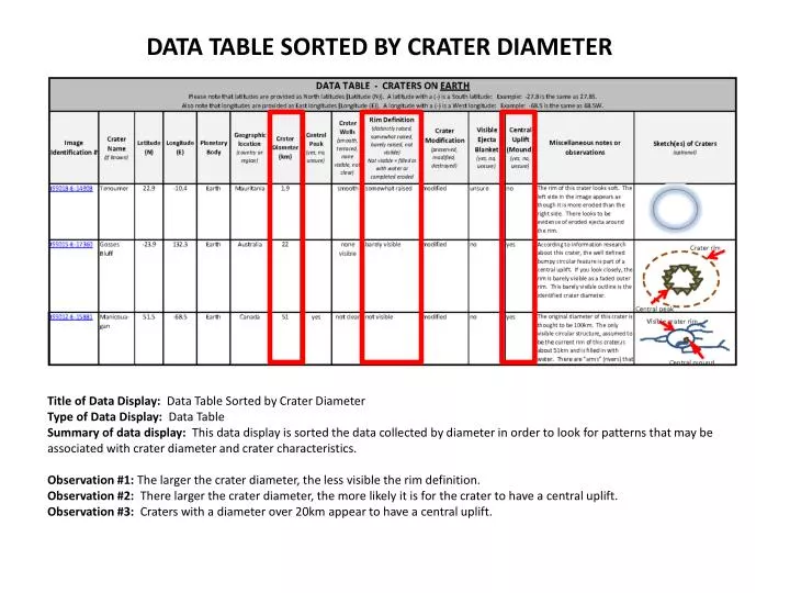
DATA TABLE SORTED BY CRATER DIAMETER. Title of Data Display: Data Table Sorted by Crater Diameter Type of Data Display: Data Table

E N D
DATA TABLE SORTED BY CRATER DIAMETER Title of Data Display: Data Table Sorted by Crater Diameter Type of Data Display: Data Table Summary of data display: This data display is sorted the data collected by diameter in order to look for patterns that may be associated with crater diameter and crater characteristics. Observation #1: The larger the crater diameter, the less visible the rim definition. Observation #2: There larger the crater diameter, the more likely it is for the crater to have a central uplift. Observation #3: Craters with a diameter over 20km appear to have a central uplift.
DATA TABLE SORTED BY LATITUDE Title of Data Display: Data Table Sorted by Latitude Type of Data Display: Data Table Summary of data display: This data display is sorted the data collected by latitude (southern-most to northern-most latitudes) in order to look for patterns that may be associated with latitude and crater characteristics. Observation #1:Craters in both the southern and northern latitudes are modified. Observation #2: Craters in both the southern and northern latitudes have central uplifts. Observation #3: Craters in both the southern and northern latitudes have no easily detectable ejecta blankets.
Title of Data Display: Craters on Earth Type of Data Display: Graph Summary of data display: This data display is showing crater sizes on Earth. Observation #1:Crater diameters on Earth, based on those observed, range from ~2km to ~50km. Observation #2:There are not many craters of similar sizes on Earth Observation #3: There is a wide range of craters sizes on Earth. Note: The more data you graph, the easier it is to make observations and look for notable patterns.
MAP SHOWING DISTRIBUTION OF IMPACT CRATERS ON EARTH Image Credit: Earth Impact Database: http://www.unb.ca/passc/ImpactDatabase/CILocSort.html = craters observed Title of Data Display: Map Showing Distribution of Impact Craters on Earth Type of Data Display: Map Summary of data display: This data display is showing the distribution of impact craters on Earth. Observation #1: Impact Craters are located on most continents on Earth. Observation #2: The craters we observed are in North America, Africa, and Australia. Observation #3: There are no impact craters found in Greenland or Antarctica.
BARELY VISIBLE RIMS Image Illustration #1: Most craters on Earth appear to be extremely modified (eroded). Rims like the one shown in the image above are often times barely visible. (ISS014-E-11841: Oasis Crater) Title of Data Display: Barely Visible Rims Type of Data Display: Image Illustration Summary of data display: This data display is illustrating a crater on Earth with a barely visible rim. Observation #1: Image caption indicates that most craters on Earth appear to be extremely modified. Observation #2: Crater in this image appears to be extremely eroded with hardly any visible detection of a wall, rim, or ejecta.
CENTRAL PEAKS Image Illustration #2: Very few craters on Earth have central peaks. As these craters are extremely modified, the central peaks can easily go unnoticed. Original crater diameters shown here were 100km (Manicouagan ISS012-E-15881) and 22 km (GossesBluff ISS015-E-17360). Title of Data Display: Central Peaks Type of Data Display: Image Illustration Summary of data display: This data display is illustrating 2 craters on Earth with central peaks. Observation #1: Central peaks in these images are very difficult to identify. Observation #2: Craters appear to have been modified by water (and possibly ice) as well as perhaps wind or environmental factors associated with a very desert-like environment.