Download
1 / 25
360 likes | 1.18k Vues
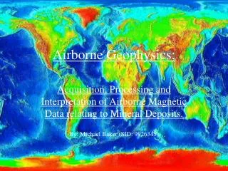
Airborne Geophysics:. Acquisition, Processing and Interpretation of Airborne Magnetic Data relating to Mineral Deposits. By: Michael Baker (SID: 9926345). Data Acquisition Methodology. Surveys are flown along a series of equally spaced parallel flight lines.

E N D
Airborne Geophysics: Acquisition, Processing and Interpretation of Airborne Magnetic Data relating to Mineral Deposits. By: Michael Baker (SID: 9926345)
Data AcquisitionMethodology • Surveys are flown along a series of equally spaced parallel flight lines. • Flight lines usually oriented north-south or east-west. • Tie-lines flown at right-angles to the main set of flight lines. • Flight-line spacing over sedimentary basins: 500m. • Fight-line spacing for mineral exploration range from 50-200m. • Flying height depends on line-spacing, can range from 150-60m.
Data AcquisitionSurvey Aircraft Features • Operating speed less than 250 km/h. • Twin engine (if not helicopter) • High-wings for better visibility • Long (> 6 hours) endurance with full operational load (250kg plus operator) • Short take-off & landing performance. • Most commonly used by AGSO is the Aero Commander (Fig. 1). Figure 1. AGSO Aero Commander (from Horsfall 1997).
Data AcquisitionAircraft Magnetometers Current industry standard are the optically pumped caesium and helium magnetometers. The two most noted magnetometers are the CS-2 caesium sensor of Scintrex Pty Ltd, and the G-822 caesium sensor of GeoMetrics Inc. (Horsfall, 1997). Both types of optically pumped magnetometers may be sampled at 0.1 s. Resolution is quoted to 0.001 nT and in ideal operation environments these magnetometers have a noise envelope of less than 0.01 nT (Horsfall, 1997). The output of these sensors is a frequency proportional to the total magnetic field. This frequency is then counted and converted into a digital format for recording by data acquisition system (DAS). This process is currently performed by the aircraft magnetometer.
Data ProcessingMethodology The processing of aeromagnetic data involves eight major steps in two phases (Luyendyk, 1997): Phase 1: Pre-processing • Verifying and editing the raw data; • Locating the data in x and y. Phase 2: Processing • Parallax corrections; • Removing diurnals; • Removing the component attributable to the Earth’s regional magnetic field; • Leveling the data; • Micro-leveling - removal of any residual leveling errors; • Gridding and contouring. Various software packages are available for processing aeromagnetic data using these steps, for a short list of packages see Luyendyk (1997).
Pre-processing • Verifying and editing raw data Raw data must be visually inspected for spikes, gaps, instrument noise and other irregularities. Ideally, this verification procedure should be carried out in the field so that any errors attributable to data acquisition can be corrected in the survey aircraft. • Locating data in X and Y Once navigation data has been checked and edited it can be merged with the magnetic data in order to locate the position of magnetic data within the survey.
Processing • Parallax correction Corrects for the distance between between the navigation reference point and magnetometer recording (referred to as the cable length) if the distance is not zero. This correction synchronizes the magnetic and navigation data. • Diurnal variation correction Diurnals collectively refer to all time variations in the Earth’s magnetic field. This variation is measured by a base station at a fixed location on the ground. These measurements are then subtracted from the aircraft magnetometer readings. This process introduces a arbitrary base-shift in the magnetic data as the magnetic field is stronger on the ground. However, this effect is not important as interpretation is based on local anomalies and not the absolute value of the magnetic field.
Processing cont. • Removing the Earth’s regional magnetic field This step involves removing the defined model of the Earth’s regional field, referred to as the Geomagnetic Reference Field (GRF). GPS navigation provides the (X,Y,Z) position data of the GRF, and it is standard practice to replace the the Z value with the mean height of the aircraft above sea level. • Leveling Surveys flow in a grid pattern contain duplicate measurements, or crossover points. Since both measurements at a crossover point are made at different times, corrections for the magnetic field drift will not be the same, leading to an error. There are three main categories for the correction of these discrepancies (Luyendyk, 1997): 1. Minimizing intersection errors by adjusting navigation data. 2. Loop closure methods. 3. Polynomial leveling (preferred method of AGSO).
Processing cont. • Micro-leveling Refers to the removal of any apparent residual errors in aeromagnetic data after standard processing and leveling. Methods for micro-leveling vary from company-to-company but generally involve filtering a grid of data to detect residual errors. The process for micro-leveling used by AGSO is described in Luyendyk (1997). • Gridding and contouring Involves a process of taking the randomly distributed survey data and interpolating the data onto a regular grid. Data collected along the flight-line is typically filtered so that the frequency content of the data is comparable to that perpendicular to the flight-line. Once a grid has been produced it can be displayed as an image or a contour map.
Interpreting AnomaliesCharacteristics of responses to magnetic surveying The form and amplitude of the magnetic response of a mineral deposit depend upon a number of variables, these include: • Concentration of magnetic minerals present; • Geometry and depth of the deposit; • Orientation of the magnetic minerals relative to magnetic north; • Inclination of the Earth’s magnetic field at the location of the deposit. As a result of these variables there are no set anomaly forms that can be regarded as giving a standard response for mineral deposits. However, attempts have been made to broadly categorize the general magnetic anomaly responses of different deposit types described below (Gunn & Dentith, 1997).
Massive Sulfide Deposits • No response, as deposit contains no magnetic mineralization (Figure 2A). • Weak magnetic low, due to mineralised solutions destroying magnetic minerals adjacent to the deposit (Figure 2B). • Small magnetic response, where magnetic minerals such as magnetite & pyrrhotite occur within the alteration pipe below the deposit (Figure 2C). • Moderate magnetic response, where magnetic minerals occur at the base of the massive sulfide lens (Figure 2D). • High magnetic response, where magnetic mineralisation occurs throughout the deposit (Figure 2E). Figure 2. Idealised responses of massive sulfide deposits (from Gunn & Dentith 1997).
Magnetite-rich Cu-Au deposits • Characteristic “bulls-eye” magnetic anomalies caused by high concentrations of magnetic minerals (fig. 3). • Mineralisation is significantly zoned. • Examples include the Tennant Creek area of the Northern Territory, Australia. Figure 3. Magnetic responses of several Tennant Creek deposits (from Gunn & Dentith 1997).
Porphyry copper deposits • Associated with intrusive stocks of generally felsic and porphyritic nature; • Typically capped by volcanics, providing an erratic high magnetic response; • Felsic porphyry is generally ferro-magnetic in nature, causing a sharp localized magnetic high surrounded by a magnetic low (Fig. 4). Figure 4. Idealised model for a copper porphyry deposit & associated magnetic response (from Gunn & Dentith, 1997).
Carbonatite-associated mineralisation • Intrusive carbonatites contain concentric zoning of carbonate rocks; • Variable magnetite concentrations cause anomalies, ideally concentric or roughly oval in shape (Fig. 5); • Approximately 50 deposits of this type have been discovered in Ontario & Quebec by aeromagnetic surveys (Gunn & Dentith, 1997). Figure 5. Magnetic response of the Mount Weld carbonatite (from Gunn & Dentith, 1997).
Diamonds • Diamonds occur within a small percentage of kimberlite and lamproite pipes; • Magnetic surveys are flown N-S at 50-100m elevation with a line spacing of 200m; • Magnetic pipes will generally appear as circular or elliptical bulls-eye anomalies; • Ease of detection depend on the magnetic response of the host lithology. Figure 6. Magnetic responses of lamproites on the Lennard Shelf, Canning Basin, Australia (from Gunn & Dentith, 1997).
Gold • Magnetic anomalies associated with gold may be due to either magnetite or pyrrotite mineralisation. • Degree of alteration & mineralisation determine polarity of anomaly. • A knowledge of the local geology is advantageous as magnetic responses are diverse. Iron ore • Magnetic signature depends on whether mineralisation is predominately magnetite or hematite. • Banded Iron Formations (BIF) represent principal host lithology. • Ores appear as zones of reduced magnetic intensity within the magnetic BIF horizons.
Data Interpretation Methodology Interpretation methodology as defined by Gunn et al. (1997) consists of inspection of computer screen and hard-copy images, maps of the aeromagnetic data, and other relevant data to define: • boundaries of magnetic units; • structures affecting the morphology of magnetic units; • depth & attitude of magnetic units; • any superposition of magnetic units; • lithological units; • chemical changes; • structural synthesis relating inferred lithologies and structure.
Boundaries of magnetic units There are three recognised types of source boundary (Gunn et al., 1997). • Large, discrete, isolated magnetic anomalies, regarded as the response of a uniformly magnetised body with the boundary traced to where the edge of the source is estimated to be. • Narrow anomalies, where source thickness is less than depth, and is represented by a line. • Concentrations of organised, semi-organised or random anomalies, drawn to encompass all associated anomalies (domain).
Structures affecting magnetic units Faulting is recognised by: • offsets in apparently similar magnetic units, • sudden discontinuities in magnetic units, • abrupt changes of the depth to magnetic units, • linear magnetic lows, caused by oxidation-weathering of magnetic units along a fault plane, • linear magnetic highs, caused by precipitation of magnetic minerals along a fault-plane. Folding can be recognised by patterns of linear magnetic anomalies.
Depth & Attitude • Estimated qualitatively. • Depth to a source related to the sharpness of the resultant anomaly. • Depth also calculated by computer modeling. • Attitude (dip) also verified by computer modeling.
Superposition of magnetic units • Important not to describe the magnetic effects of superimposed magnetic sources as a single source. • Depth estimates and different contour gradients are used for identification. Lithological units • Amplitude of response can indicate possible lithology. • Outlines of magnetic units (e.g., intrusions). • Character of magnetic units (e.g., lava flows have a semi-random anomaly due to inhomogeneity of magnetic properties in the flow) (Gunn et al., 1997).
Chemical change • Indicated by changes in magnetic intensity within a magnetic unit, due to metamorphism, alteration and weathering. Structural synthesis • Presented data is a compromise between what can be seen and what can be inferred. • Presentation of data will depend on data set used, personal interpretation, and software/hardware used.
Total magnetic intensity maps The basic AGSO products for all aeromagnetic surveys are line contour maps (Fig. 7). Usually produced at 1:250000 and 1:100000 scales (Gunn et al., 1997). Line contour maps give a superior representation of contour gradients than images, making them more useful for estimating source outlines, depths and dips. It is also easier to extract amplitude values from line contour maps than images. Figure 7. Total magnetic intensity, reduced to pole (red high-blue low), Highland Rocks, Northern Territory (from Gunn et al., 1997).
Synthesis Interpretation methodology is used to produce a type of solid geological map (fig. 8) which combines outlines of rock units confidently identified, and other units that have been mapped by geophysical means (notice correlation of features with Figure 7). Geological features such as faults, folds, depth to source and dip can also be shown on interpretation maps than have been inferred from aeromagnetic data. Figure 8. Final interpretation map, Highland Rocks, Northern Territory (from Gunn et al., 1997).
References Horsfall, K.R., 1997. Airborne magnetic and gamma-ray data acquisition. AGSO Journal of Australian Geology & Geophysics, 17(2), 23-30. Luyendyk, A.P.J., 1997. Processing of airborne magnetic data. AGSO Journal of Australian Geology & Geophysics, 17(2), 31-38. Gunn, P.J., 1997. Quantitative methods for interpreting aeromagnetic data: a subjective review. AGSO Journal of Australian Geology & Geophysics, 17(2), 105-113. Gunn, P.J. & Dentith, M.C., 1997. Magnetic responses associated with mineral deposits. AGSO Journal of Australian Geology & Geophysics, 17(2), 145-158. Gunn, P.J., Maidment, D. & Milligan, P.R., 1997. Interpreting aeromagnetic data in areas of limited outcrop. AGSO Journal of Australian Geology & Geophysics, 17(2), 175-185.