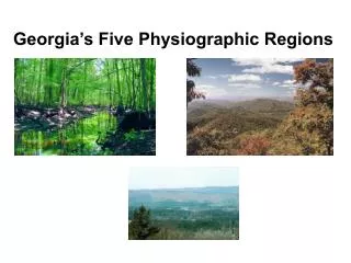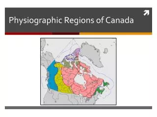
Physiographic Regions
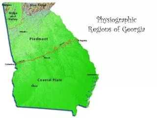
Physiographic Regions. Within the U.S., geographers have identified over 30 natural regions. These regions, called physiographic provinces are based on similarities in land formations, elevation, location, and use of the land…among other things. Coastal Plain. Largest region in Georgia

Physiographic Regions
E N D
Presentation Transcript
Physiographic Regions • Within the U.S., geographers have identified over 30 natural regions. • These regions, called physiographic provinces are based on similarities in land formations, elevation, location, and use of the land…among other things.
Coastal Plain • Largest region in Georgia • During prehistoric times, this region was covered by ocean • As the water moved inland, it created hills and other landforms • The seashells and other aquatic life sank to the seafloor, creating soft rock called limestone
Coastal Plain (cont.) • Over time, rivers and streams deposited rocks and clay that eroded from the mountains. • As a result, thousands of feet of sediment -settled deposits - covered the ocean floor • Ocean retreated leaving limestone, clay and sediment deposits • This region is known as…
The Coastal Plain! It extends from along the Atlantic and Gulf Coasts from Massachusetts to Mexico
The interior boundary of the coastal plain is marked by the Fall Line. • This line is actually a zone - the prehistoric shoreline • The land north of it is higher in elevation, causing rivers and streams to pick up speed as they move south • Home to Okefenokee Swamp - largest swamp in North America.
THE COASTAL PLAIN level
The Piedmont Georgia’s 2nd largest province French word for “foot of the mountains” 500 - 1700 feet above sea level
Rolling hills with many valleys • Hills can be tall and mistaken for mountains • Hardwood and pine trees found here • Land will support crops like cotton, soybeans and wheat
- While the Coastal Plain has Limestone, the Piedmont has bedrock (granite,gneiss, marble,etc)…which is very hard. - Bedrock is easy to be seen when the soil is washed away.
Piedmont has many streams and rivers • Because of bedrock, they have shallow beds • Exposed rocks create frequent rapids, making navigation impossible for large boats
Georgia’s most beautiful physiographic province • The Blue Ridge Mountains…the highest in the Appalachian Highlands • The Blue Ridge region stretches from Georgia to Pennsylvania
Georgia’s Highest Mountain • Brasstown Bald is 4,784 feet above sea level Springer Mtn (3782 ft) is the beginning of the Appalachian Trail The App. Trail is 2158 miles long.
Blue Ridge • The height of the mountains cools the warm air currents coming from the Gulf of Mexico. This produces rain throughout the year! • Less than 1% of Georgia’s farm land • Apples, corn, and timber
Ridge and Valley Region In Georgia, located west of Blue Ridge Stretches 1,200 miles from NY to Alabama Long parallel ridges over looking valleys
From the ground, the ridges look like mountains… …But the highest point is only 700-1600 feet from the base
Tell me about this region… • The Ridge and Valley province is located between the Blue Ridge, Piedmont, and Plateau regions. • Consists of softer sedimentary rocks like sandstone (ridges) and limestone and shale (valleys) • Ridges covered in forest, Valleys used for pastures and farming
Farming in forests??? Well, the valleys actually are not covered in forest, making it moderately suited for farming! • Average growing season of 210-220 days • Variety of crops can be grown (corn,soy beans, wheat, cotton)
Appalachian Plateau • This is the smallest of the physiographic regions in Georgia. • Located in the far northwestern corner of Georgia. • Has the only source of coal in Georgia. • Known as TAG Corner