Abraham Ortelius
History about Abraham Ortelius

Abraham Ortelius
E N D
Presentation Transcript
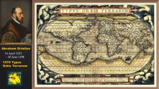
Abraham Ortelius 14 April 1527 – 28 June 1598 1570 Typus Orbis Terrarum
Abraham Ortelius Abraham Ortelius also Ortels, Orthellius, Wortels; 14 April 1527 – 28 June 1598) was a Brabantian cartographer and geographer, conventionally recognized as the creator of the first modern atlas, the Theatrum Orbis Terrarum (Theatre of the World). Ortelius is often considered one of the founders of the Netherlandish school of cartography and one of the most notable figures of the school in its golden age (approximately 1570s–1670s). The publication of his atlas in 1570 is often considered as the official beginning of the Golden Age of Netherlandish cartography. He is also believed to be the first person to imagine that the continents were joined before drifting to their present positions. Text Wikipedia Anders Dernback slideshow
Map of the Persian Empire Maris Pacifici, more accurately named the Descriptio Maris Pacifici ("Description of the Pacific Ocean"), was the first dedicated map of the Pacific to be printed. It is considered an important advancement in cartography.
Life Ortelius was born on 14 April [O.S. 4 April] 1527 in the city of Antwerp, which was then in the Habsburg Netherlands (modern-day Belgium). The Orthellius family were originally from Augsburg, a Free imperial city of the Holy Roman Empire. In 1535, the family had fallen under suspicion of Protestantism. Following the death of Ortelius's father, his uncle Jacobus van Meteren returned from religious exile in England to take care of Ortelius. Abraham remained close to his cousin Emanuel van Meteren, who would later move to London. In 1575 he was appointed geographer to the king of Spain, Philip II, on the recommendation of Arias Montanus, who vouched for his orthodoxy.
He travelled extensively in Europe He travelled extensively in Europe and is specifically known to have traveled throughout the Seventeen Provinces; in southern, western, northern, and eastern Germany (e.g., 1560, 1575–1576); France (1559–1560); England and Ireland (1576); and Italy (1578, and perhaps twice or thrice between 1550 and 1558). Beginning as a map-engraver, in 1547 he entered the Antwerp Guild of Saint Luke as an illuminator of maps. He supplemented his income trading in books, prints, and maps, and his journeys included yearly visits to the Frankfurt book and print fair, where he met Gerardus Mercator in 1554. In 1560, however, when travelling with Mercator to Trier, Lorraine, and Poitiers, he seems to have been attracted, largely by Mercator's influence, towards the career of a scientific geographer. He died in Antwerp
Map publisher In 1564 he published his first map, Typus Orbis Terrarum, an eight- leaved wall map of the world, on which he identified the Regio Patalis with Locach as a northward extension of the Terra Australis, reaching as far as New Guinea. This map subsequently appeared in reduced form in the Terrarum (the only extant copy is in now at Basel University Library). He also published a two-sheet map of Egypt in 1565, a plan of the Brittenburg castle on the coast of the Netherlands in 1568, an eight-sheet map of Asia in 1567, and a six-sheet map of Spain before the appearance of his atlas. In England Ortelius's contacts included William Camden, Richard Hakluyt, Thomas Penny, Puritan controversialist William Charke, and Humphrey Llwyd, who would contribute the map of England and Wales to Ortelius's 1573 edition of the Theatrum
The Theatrum Orbis Terrarum inspired a six-volume work titled Civitates orbis terrarum, edited by Georg Braun and illustrated by Frans Hogenberg with the assistance of Ortelius himself, who visited England to see his friend John Dee in Mortlake in 1577, and Braun tells of Ortelius putting pebbles in cracks in Temple Church, Bristol, being crushed by the vibration of the bells
Map of Flanders from the Theatrum orbis terrarum, 1574, The Phoebus Foundation
Later maps In 1579 Ortelius brought out his Nomenclator Ptolemaicus and started his Parergon (a series of maps illustrating ancient history, sacred and secular). He also published Itinerarium per nonnullas Galliae Belgicae partes (at the Plantin press in 1584, and reprinted in 1630, 1661 in Hegenitius, Itin. Frisio-Hoil., in 1667 by Verbiest, and finally in 1757 in Leuven), a record of a journey in Belgium and the Rhineland made in 1575. In 1589 he published Maris Pacifici, the first dedicated map of the Pacific to be printed.