Download

1 / 9
0 likes | 6 Vues
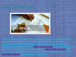
GIS and CAD are powerful tools that, when used together, enhance golf course planning. GIS provides essential spatial analysis, while CAD ensures precise design and visualization. Integrating these technologies results in accurate Golf Course Drawings, efficient Grading Plans, and sustainable designs. <br>Golf Course Drawings,<br>Drawing of Golf Course,<br>Golf Course Master Plan,<br>Golf Course 3D Model, <br>Grading Plan,<br>Cad Service,<br>Cut and Fill Calculations,<br>Irrigation Plan Drawing<br><br>

E N D
How to Use GIS and CAD Together for Golf Course Planning? Use GIS and CAD Together Golf course planning is a complex process that requires precise design, analysis, and execution to create a sustainable and visually appealing course. To achieve this, Geographic Information Systems (GIS) and Computer-Aided Design (CAD) are two essential tools that work together seamlessly. GIS provides spatial data and analysis, while CAD helps in creating detailed design elements, such as Golf Course Drawings, Grading Plans, and Irrigation Plan Drawings. By integrating these technologies, golf course architects and planners can achieve higher efficiency, accuracy, and sustainability in their projects. The Role of GIS in Golf Course Planning GIS plays a crucial role in golf course planning by providing spatial data analysis and mapping capabilities. This technology allows planners to assess topography, land use, environmental constraints, and other crucial factors.
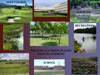
1. Terrain and Topography Analysis Before creating a Golf Course Master Plan, GIS helps in analyzing elevation, slopes, and landforms. Digital Elevation Models (DEMs) generated using GIS allow designers to understand natural contours and optimize the layout accordingly. 2. Environmental Impact Assessment GIS enables planners to analyze environmental data, including vegetation, water bodies, and wildlife habitats. This assessment ensures that the design adheres to sustainability standards and minimizes ecological disruption. 3. Site Selection and Land Use Mapping Using GIS, planners can overlay different land-use maps to determine the best areas for fairways, greens, and clubhouses. It also aids in identifying potential hazards and drainage issues that could affect the course’s functionality. The Role of CAD in Golf Course Planning CAD is instrumental in creating detailed Drawing of Golf Course layouts and 3D visualizations. It allows architects to develop precise models, ensuring the feasibility of design elements such as fairways, bunkers, greens, and water features. 1. Detailed Course Layout Design CAD software is used to draft and refine Golf Course Drawings, ensuring that each element fits the desired aesthetic and functional goals. Planners can create multiple design iterations and optimize spacing for smooth playability. 2. Grading Plan Development A Grading Plan is essential for proper drainage and playability. CAD allows designers to manipulate terrain features by defining slopes, elevations, and contours, ensuring a balanced design that minimizes erosion and maintenance costs. 3. 3D Visualization and Modeling A Golf Course 3D Model provides stakeholders with a realistic representation of the proposed layout. It helps in evaluating sightlines, elevation changes, and overall course aesthetics before construction begins.
Integrating GIS and CAD for Optimal Golf Course Design Combining GIS and CAD enhances golf course planning by leveraging spatial analysis with precise design tools. Here’s how the integration works: 1. Data Collection and Importation GIS data, including elevation models, satellite imagery, and land-use maps, are imported into CAD software. This data provides a foundation for accurate Golf Course Drawings and Grading Plans. 2. Terrain Modification and Cut and Fill Calculations Using GIS-derived terrain data, CAD software calculatesCut and Fill Calculations, ensuring that earthwork is minimized. This step helps balance the amount of soil moved, reducing costs and environmental impact. 3. Hydrology and Irrigation Planning GIS hydrological analysis determines water flow patterns, while CAD is used to create detailed Irrigation Plan Drawings. Proper irrigation design ensures efficient water distribution, reducing waste and maintenance costs. 4. Visualization and Stakeholder Approval Once the GIS and CAD models are integrated, planners can generate 3D renderings and simulations. These visuals help stakeholders, including investors and course managers, understand the design before construction begins. Benefits of Using GIS and CAD Together 1. Improved Accuracy and Efficiency Combining GIS and CAD enhances precision in planning, reducing errors in Golf Course Master Plan development. Automated calculations and spatial analysis streamline decision-making. 2. Cost Savings
Optimized Cut and Fill Calculations ensure that minimal earth is moved, reducing labor and material costs. Efficient irrigation designs also contribute to lower operational expenses. 3. Sustainability and Environmental Compliance GIS helps in preserving natural landscapes, while CAD ensures proper grading and drainage to prevent soil erosion and waterlogging. Together, they contribute to an eco-friendly golf course design. 4. Enhanced Communication and Collaboration Integration allows for seamless data sharing between GIS analysts, CAD designers, and construction teams. This ensures that all stakeholders are aligned, reducing miscommunication and project delays. CAD Services for Golf Course Planning Many golf course developers rely on Cad Services to handle the technical aspects of design. These services include: ● Site Analysis and Planning ● Fairway and Green Layouts ● Cart Path and Bunker Design ● Irrigation and Drainage Systems ● 3D Visualization and Rendering Conclusion GIS and CAD are powerful tools that, when used together, enhance golf course planning. GIS provides essential spatial analysis, while CAD ensures precise design and visualization. Integrating these technologies results in accurate Golf Course Drawings, efficient Grading Plans, and sustainable designs. Whether developing a new course or renovating an existing one, leveraging GIS and CAD can significantly improve the planning and execution process, leading to world-class golf courses that are both visually stunning and functionally efficient. ● Golf Course Drawings, ● Drawing of Golf Course,
● Golf Course Master Plan, ● Golf Course 3D Model, ● Grading Plan, ● Cad Service, ● Cut and Fill Calculations, ● Irrigation Plan Drawing https://medium.com/@hemantvizent/the-power-of-3d-vector-maps-enhancing-archite ctural-illustration-and-beyond-7f179ba47886 https://vizentbloggg.blogspot.com/2025/03/the-power-of-3d-vector-maps-enhancing.ht ml http://www.dfwdedicated.com/guestbook/ https://qr.ae/pYl0tf https://justpaste.it/h05fb https://linkeei.com/1740806430851204_ 41093 https://tokemonkey.com/post/290746_https-tokemonkey-com-read-blog-207754-how-b rands-are-using-3d-product-visualizat.html https://adolaa.net/the-art-drawing-of-golf-course-from-concept-to-reality/30395?previe w=1 https://topkif.nvinio.com/post/88673_the-art-drawing-of-golf-course-from-concept-to-r eality-https-geoshott-com-golf-c.html https://sites.google.com/view/power-of-3d-vector/home https://www.slideserve.com/Hemant56/how-brands-are-using-3d-product-visualization -for-marketing-off-site-vizent-kriti https://www.edocr.com/v/b9mrqg2b/hemantvizent/furniture-3d https://pdf.ac/1Zjd2Z http://depositfiles.com/files/8dzv4m0yr
https://www.sendspace.com/file/dey6sg https://www.4shared.com/s/fy8TI5NmGku https://www.scribd.com/document/834775486/How-Brands-Are-Using-3D-Product-Visu alization-for-Marketing-off-Site-Vizent-Kriti https://www.mediafire.com/file/lrrlevwf2fmd8cm/How+Brands+Are+Using+3D+Product+ Visualization+for+Marketing+__off-site+Vizent+Kriti.pdf/file https://www.slideshare.net/slideshow/how-brands-are-using-3d-product-visualization-f or-marketing-__off-site-vizent-kriti-pdf/276217014 https://mega.nz/fm/eEJmSRzb https://www.pearltrees.com/vizenthemant/item695870975 https://www.vevioz.com/read-blog/305565 https://paperpage.in/blogs/244414/The-Power-of-3D-Vector-Maps-Enhancing-Architect ural-Illustration-and https://undewall.com/blogs/40966/The-Power-of-3D-Vector-Maps-Enhancing-Architect ural-Illustration-and https://www.behance.net/gallery/220731215/The-Power-of-3D-Vector-Maps https://hackmd.io/@vcQK7owJRZSBVaMBT_QRSw/BJ0-kpSiyx https://hemantvizent.wixsite.com/vizenthemant/post/the-power-of-3d-vector-maps-en hancing-architectural-illustration-and-beyond https://vizentsolution.weebly.com/blog1/the-power-of-3d-vector-maps-enhancing-archi tectural-illustration-and-beyond https://share.evernote.com/note/0862737e-6c6c-92a4-3197-680be0eef7dd https://0007hemantsingh.wordpress.com/2025/03/05/the-power-of-3d-vector-maps-en hancing-architectural-illustration-and-beyond/ https://timessquarereporter.com/technology/how-3d-modeling-services-are-transformi ng-e-commerce-through-ar-product-visualization https://vocal.media/stories/how-3-d-modeling-services-are-transforming-e-commerce -through-ar-product-visualizationhttps://penzu.com/p/6300bbb037faa818
https://hallbook.com.br/blogs/489274/How-3D-Modeling-Services-Are-Transforming-E-https://hallbook.com.br/blogs/489274/How-3D-Modeling-Services-Are-Transforming-E- commerce-Through-AR https://www.bookmarktheme.com/author/vizentblogg/ https://www.facebook.com/share/p/18mLBEiJ3d/ https://pin.it/6wsBktP2nhttps://x.com/HemantVizent/status/1897179540059037845 https://www.instagram.com/p/DGzvlIzS64a/?utm_source=ig_web_copy_link&igsh=MzRlO DBiNWFlZA== https://anotepad.com/notes/6dxgkwn7 https://www.expatriates.com/cls/58931729. html?previewhttps://www.masterbookmarks.com/author/vizent/ https://www.a1bookmarks.com/author/vizent/ https://www.addbusinessnow.com/how-3d-modeling-services-are-transforming-e-com merce-through-ar-product-visualization/ https://www.bookmarkcart.com/author/vizent/ https://www.alkalizingforlife.com/board/board_topic/6120136/6624330.htm https://www.ancientforestessences.com/board/board_topic/349324/6624331.htm https://www.mrclarksdesigns.builderspot.com/board/board_topic/690695/6624333.htm https://www.coffeesix-store.com/board/board_topic/7560063/6624334.htm https://www.crossroadsbaitandtackle.com/board/board_topic/9053260/6624345.htm https://www.foolaboutmoney.ezsmartbuilder.com/board/board_topic/7315936/6624335.ht m https://www.greencarpetcleaningprescott.com/board/board_topic/7203902/6624337.htm https://www.milliescentedrocks.com/board/board_topic/2189097/6624338.htm https://www.sunemall.com/board/board_topic/8431232/6624340.htm http://taekwondomonfils.com/board/board_topic/5750834/6624341.htm
https://www.tai-ji.net/board/board_topic/4160148/6624343.htm https://www.thepartyservicesweb.com/board/board_topic/3929364/6624342.htm https://www.thepetservicesweb.com/board/board_topic/2701171/6624329.htm https://www.vhs80.com/board/board_topic/6798823/6624320.htm https://www.wordsdomatter.com/board/board_topic/5204323/6624315.htm https://uycart.com/399/posts/3-Services/24-IT/2232757-The-Power-of-3D-Vector-Maps- Enhancing-Architectural-Illustration-and-Beyond.html http://pixolinks.com/536/posts/3-Services/24-IT/2068542-The-Power-of-3D-Vector-Map s-Enhancing-Architectural-Illustration-and-Beyond.html https://fdlclassifieds.com/398/posts/3-Services/24-IT/2426806-The-Power-of-3D-Vector -Maps-Enhancing-Architectural-Illustration-and-Beyond.html https://postezads.com/536/posts/3-Services/24-IT/2109068-The-Power-of-3D-Vector-Ma ps-Enhancing-Architectural-Illustration-and-Beyond.html https://instantadz.com/460/posts/3-Services/24-IT/2278170-The-Power-of-3D-Vector-M aps-Enhancing-Architectural-Illustration-and-Beyond.html https://postquickads.com/536/posts/3-Services/24-IT/2394068-The-Power-of-3D-Vector -Maps-Enhancing-Architectural-Illustration-and-Beyond.html https://www.comadz.com/457/posts/3-Services/24-IT/2380185-The-Power-of-3D-Vector- Maps-Enhancing-Architectural-Illustration-and-Beyond.html https://profreeads.com/73/posts/3-Services/24-IT/680893-The-Power-of-3D-Vector-Map s-Enhancing-Architectural-Illustration-and-Beyond.html https://postezad.com/393/posts/3-Services/24-IT/2221883-The-Power-of-3D-Vector-Map s-Enhancing-Architectural-Illustration-and-Beyond.html https://www.adslov.com/457/posts/3-Services/24-IT/2348324-The-Power-of-3D-Vector- Maps-Enhancing-Architectural-Illustration-and-Beyond.html https://adsghar.com/410/posts/3-Services/24-IT/2380195-The-Power-of-3D-Vector-Maps -Enhancing-Architectural-Illustration-and-Beyond.html https://www.petadshub.com/457/posts/11-Other-Pets/162-All-Others/2920330-The-Powe
r-of-3D-Vector-Maps-Enhancing-Architectural-Illustration-and-Beyond.htmlr-of-3D-Vector-Maps-Enhancing-Architectural-Illustration-and-Beyond.html https://fwebdirectory.com/456/posts/3-Services/24-IT/3194427-The-Power-of-3D-Vector -Maps-Enhancing-Architectural-Illustration-and-Beyond.html https://www.adshoo.com/457/posts/3-Services/24-IT/2137799-The-Power-of-3D-Vector- Maps-Enhancing-Architectural-Illustration-and-Beyond.html https://ursads.com/71/posts/3-Services/24-IT/2284849-The-Power-of-3D-Vector-Maps-E nhancing-Architectural-Illustration-and-Beyond.html https://foldads.com/74/posts/3-Services/24-IT/2691032-The-Power-of-3D-Vector-Maps-E nhancing-Architectural-Illustration-and-Beyond.html https://greatclassified.com/83/posts/3-Services/24-IT/1889013-The-Power-of-3D-Vector- Maps-Enhancing-Architectural-Illustration-and-Beyond.html https://nextfreeads.com/403/posts/3-Services/24-IT/2805578-The-Power-of-3D-Vector- Maps-Enhancing-Architectural-Illustration-and-Beyond.html https://letspostfree.com/403/posts/3-Services/24-IT/2572273-The-Power-of-3D-Vector- Maps-Enhancing-Architectural-Illustration-and-Beyond.html https://freeclassipress.com/401/posts/3-Services/24-IT/1918944-The-Power-of-3D-Vector -Maps-Enhancing-Architectural-Illustration-and-Beyond.html https://backlink4ranking.com/https://backlinkoffer.com/ https://swiftbacklink.com/https://backlinkjunction.com/ https://addwebbacklink.com/https://backlinkadda.com/ https://seolinksjuice.com/https://backlinksbazar.com/ https://www.backlinkwali.com/https://click4backlink.com/