Download
1 / 11
110 likes | 360 Vues
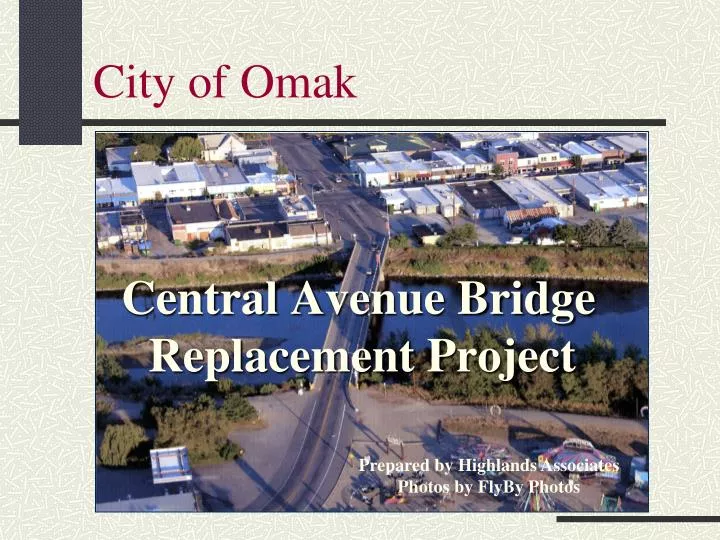
City of Omak. Central Avenue Bridge Replacement Project. Prepared by Highlands Associates Photos by FlyBy Photos. Bridge Background.

E N D
City of Omak Central Avenue Bridge Replacement Project Prepared by Highlands Associates Photos by FlyBy Photos
Bridge Background The Central Avenue Bridge, completed in 1924, is known to the WSDOT as Bridge 155/111SP. The Bridge, part of SR 155, connects Main Street (SR 215) to SR 97 in East Omak. There has been a 500% increase in population since the bridge was constructed The bridge is: • essential to the community for transportation circulation • only pedestrian access across the Okanogan River between west and east Omak. • traveled by school children attending East Elementary school and those students in east Omak who attend middle school and high school on the west side • Omak School District buses travel across the bridge an average 70 times per day carrying over 12, 600 students per school year. The City’s Eastside Park, just at the east end of the Bridge, is a major recreation site providing baseball, soccer, swimming, tennis, skate boarding, rodeo and other equestrian events and other recreational activities.
Current Bridge Details Location: State Route 155 Spur-Omak crossing the Okanogan River in the City of Omak. State Route: Rural Minor Arterial Classification Posted Speed: 25 MPH Construction: 443 ft. long concrete arch bridge completed 1924. 2 – 10 ft. wide lanes, with 5 ft. sidewalks on each side (In an effort to protect pedestrians, steel posts and rails were installed 1960 on the north sidewalk narrowing the walk to 3 ft. 2 in. wide) West Approach: Central Avenue is 223 ft. long from the signalized intersection with SR 215 – Main Street – to an angle point at the west end of the bridge. Central Avenue is 54 ft. wide between Main Street and the west bridge end, with two 13.5 ft. lanes, an 11 ft. left turn, and 8 ft. parking lanes both sides. At the angle point on the west end of the bridge, two 13.5 ft. lanes, and the 11 ft. left turn lane, narrow to two 10 ft. wide bridge lanes. East Approach: Omak Avenue transitions in 321 ft. from the same 54 ft. wide roadway width as Central Avenue to the two 10 ft. bridge lanes, with an angle point in the middle of the transition.
Traffic Details Information provided in the 1998 SR 215 Corridor Study states that the intersection of Main Street and Central Avenue had the first, and for many years, the only traffic signal in Okanogan County. This intersection at the heart of Omak’s downtown is one of the busiest intersections the County. Recent turn counts for the Central Avenue Intersection provided by Okanogan County show that approximately 5,464 vehicles use the intersection during the afternoon peak period from 3:30 pm to 5:30 pm. During this period well over 1,500 vehicles use the Central Avenue Bridge (SR155/111SP).
Identified Problems The bridge is a transportation bottleneck – too narrow for today’s safety standards. It is an accident risk for vehicles and pedestrians. A recent Rural Transportation study sited lack of pedestrian access to the bridge, is too narrow for large trucks, motor homes, school buses, and emergency vehicles; and adds to downtown congestion.
Identified Problems A 1972-73 Corp of Engineer Exit Report stated that the bridge will not structurally survive another high water event. Flooding will create severe erosion to the riverbank and threaten local businesses south of the bridge.
Identified Problems The City of Omak urges that the Central Avenue Bridge not only be evaluated for safety for pedestrians and vehicles using the bridge but also for stability of the structure.
Transportation Studies • The Greater Omak Area Comprehensive Plan Update (2008) recommends widening or replacing the Central Avenue Bridge. • The City of Omak’s Capital Facilities Plan (2004 – presently being updated) includes the Central Avenue Bridge project in it’s prioritized list of capital projects. • The City, in cooperation with the Central Okanogan Valley Transportation Team, completed a study of the SR 215 corridor in 1998 that included analysis of a new bridge at Fourth Avenue and use Central Avenue Bridge for pedestrians only. • Under the Subprogram I1 Mobility 20-year Strategies, in the Washington State Highway System Plan (HSP), the present Central Avenue bridge is identified as needing replacement.
Transportation Studies In the mid 1990’s the City completed a study of the SR 215 corridor that included analysis of a new bridge at Fourth Ave rather than replacement of the Central Ave Bridge. A new Fourth Avenue Bridge has the greatest potential for removing through traffic from Main Street, however it is also the most expensive of the options for addressing traffic in downtown Omak. Any rerouting of traffic to a new bridge on Fourth Avenue would also entail significant changes to traffic patterns between SR-97 through East Omak to downtown.
Budget The City has been working in both Olympia and Washington DC on securing funding for a new bridge. Funding for the project was cut from the 2006/07 Transportation Budget at the last minute; it would have provided funding for a bridge by 2017. Total Project Budget current estimate $ 22 Million
Request for Assistance The City would like to have a better understanding of the costs and transportation implications. The City, working with the Colville Tribes as the lead, will soon be undertaking a feasibility study that will hopefully address some of the following: • Options and alternative locations for new bridge • Cost estimates and visual design development (Fourth Ave to SR 97, straight Central Bridge) • Community costs (if Central Bridge is removed and replaced) • ROW needs and costs The City would like WSDOT cooperationas the feasibilityprocess moves along and the Commission’s endorsement of the critical need for a new bridge.