Download
1 / 27
270 likes | 400 Vues
The Automatic Identification System (AIS) serves as a crucial technology for improving navigational safety in U.S. waters. Established by Congress in 1997, AIS is endorsed by industry leaders to enhance Vessel Traffic Service (VTS) systems. This digital broadcast system communicates vital vessel information such as position, speed, and cargo status. With capabilities for rapid data transmission, AIS plays a pivotal role in ensuring maritime safety and efficiency, adhering to international protocols. Ongoing collaboration and rulemaking aim to expand AIS usage across all navigable waters, impacting thousands of vessels.

E N D
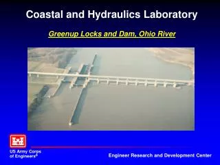
Coastal River Information Service Real Time Electronic Data via Automatic Identification System (AIS)
Congress supports/mandates AIS! • In 1997, Congress…stated that AIS “technology should be the foundation of any future VTS system” and that it “strongly believes that this technology will significantly improve navigational safety, not just in select VTS target ports, but throughout the navigable waters of the U.S”, and, that we “continue working with stakeholders…”
Industry endorses AIS! • In 1999, the National Dialog Group, comprised of the marine private and public representatives, stated they: “strongly endorse the widespread use of AIS employing dGPS and onboard transponder technologies…that national use of AIS technology on the greatest number of vessels is essential both as a foundation of a VTS system…improving navigation safety…promote universal use of AIS technology”, which will “be less intrusive and distracting to the mariner than will a voice-based control system…” • In 2006 at Inland Waterways Conference Industry asked the Federal Agencies to collaborate and provide one data standard that would meet all their reporting requirements.
What is AIS? • Autonomous Continuous Station-to-Station Navigation Broadcast System • 3 modes of operation: automatic/self-reporting, assigned, interrogation/polling • Open protocol & non-proprietary • Robust capability: can handle up to 4500 reports per minute • Frequency agile: any 2 channels in the VHF Marine Band • Versatile: multiple standard interfaces and display options • AIS is an international protocol which adheres to the International Telecommunications Union Sector for Radiocommunications (ITU-R) Recommendation M.1371-1 standard. • Ship-to-ship, ship-to-shore, and shore-to-ship communication of information (e.g., vessel identity, destination, cargo, position, speed, course) • AIS is a shipboard digital broadcast system that continually transmits and receives voiceless exchange of vessel navigational information • AIS first used in Valdez, Alaska. Mandated by OPA 90. (Automatic Dependant Surveillance System). • Carriage mandated by the Marine Transportation Security Act
What AIS broadcasts • MARITIME MOBILE SERVICE INDENTIFIER • UNIVERSAL TIME STAMP (GPS) • Dynamic Datatransmits intervalevery 2-10 seconds • POSITION & ACCURACY (+/-10m) • COURSE OVER GROUND • SPEED OVER GROUND • HEADING • RATE OF TURN • VESSEL IMO NUMBER • COLREG NAVIGATION STATUS • Static & Voyage Dataevery 6 minutes or upon change • VESSEL NAME & CALL SIGN • VESSEL TYPE & DIMMENSIONS • STATIC DRAFT • HAZARDOUS CARGO FLAG • DESTINATION & ETA • Safety Related & Binary Applications • SHORT TEXT MESSAGING < 156 characters • DATA MESSAGING & BINARY APPLICATIONS • Weather & Hydrological Information- • NOAA Physical Oceanographic Real Time System • NWS-Real-time weather buoy (C-MAN station) • USACE Real-time Current Velocity System (RTCV) • Vessel Traffic Service (VTS)- • ATON Discrepancies • Distress Alerts • Urgent Notices & Warnings • Traffic Advisories • Radar Overlay / Pseudo-targets • Additional Hydro & Meteorological Information
Forthcoming USCG AIS Rule • Announcement published October 31st, 2005 • Extend to all U.S. navigable waters • Potentially could effect 17,000 vessels. • Commercial self-propelled vessel of > 65 feet • No exceptions • Towing vessel > 26 feet and > 600 hp • Vessels carrying >50 passengers • Hi-Speed vessels carry > 12 passengers • Certain dredges / floating plants, and • Vessel moving certain dangerous cargoes • Forthcoming rulemaking will address timeline • Reasonable time will be given for installation/use • Waiver provisions already exist
Used by Saint Lawrence Seaway since 2002 Improves efficiency, lock utilization, mitigates racing & wait time Allows Locks to perform Maintenance based on que Allows industry to save fuel Lock Order Message
Current U.S. AIS Capability • USCG VTS • NY/NJ, LMR, HOU/GAL, Tampa, Port Arthur, Berwick Bay, LA/LB, SF, Puget and Prince Wm. Sound • Joint Harbor Operations Centers (USCG/USN JHOC) • MOA with St. Lawrence Seaway • USCG R&D AIS Efforts • Prototype AIS installations and network • Coverage analysis and evaluation • Evaluating AIS & VHF voice communications compatibility • Alaska Secure Passive AIS • Gulf of Mexico Offshore Platforms • NOAA Weather Buoys with AIS • Commercial Low Earth Orbit Satellite-Orbcomm launch
USCG Nation-wide AIS Project Overview • Automatic reception of AIS information nationwide out to 2000nm from shore • Transmission of standard messages out to 24nm from shore • Display information to a Common Operational Picture (COP) and share with other agencies • 3 Phase implementation
NAIS requirements for inland Waterways • Receive only in the following locations: • Huntington, WV • Cincinnati, OH • Pittsburgh, PA • St Louis, MO • Memphis, TN
USCG-USACEAIS Demo project – Louisville, KY • VTS Louisville – high water operations • Only US VTS currently without AIS • Needed to monitor traffic • Manage river at high water • Site survey – January 2007 • Full transmit/receive capability • AIS transmit capability “test bed” • Met-Hydro binary • Vessel report rate • Shared USCG-ACOE infrastructure
CRIS Meetings • Workshop on Waterway Navigation Electronic Data and Information Exchange, January 2007, Pittsburgh, PA • Coastal and Inland River Service Data Workshop, April 2-5 2007, Alexandria, VA • Attendees: Gail Perkins (MARAD), Maureen Kenny (NOAA), Dick Ash (USACE), Doug McDonald (IWR), Michael Winkler (ERDC), Jorge Arroyo (USCG), Gene Diotalevi (USCG), Burt Lahn (USCG), Brian. Tetreault (USCG) • Standards and Classifications Workshop, May 22, 2007 Alexandria, VA • Attendees: Dick Ash (USACE), Bob Brown (MARAD), Burt Lahn (Coast Guard), Dave Lichy (IWR), Doug McDonald (IWR), Tony Niles (ERDC), Michael Winkler (ERDC)
CRIS Products • Summary Reports from all three meetings have been created and reviewed • CRIS Project Plan has been drafted and sent out for review • Document Define CRIS Data Elements • Groove Site being created
Why is the Corps part of AIS • Improve Safety at Corps Projects • Improve Levels of Reliability • Improve lock and traffic management strategies • Real Time Operational data – to the vessel • Electronic Navigation Charts Updates • Lock condition (available, queue) • Real time current and wind velocities • River stage, water releases • Navigation safety information (hazards, AtoN status, etc.)
Why is the Corps part of AIS • Statistical data Received from the vessel will allow Corps to Automate OMBIL and LPMS, $3 million plus in annual savings • Tow sizes • Commodities • Tons • Location, speed, heading, destination
Current Initiatives • AIS: USCG • BargEx: Industry • RiverNet: Port of Pittsburgh/Corps • Real Time Current Velocity (RTCV): Corps/USCG • Washington State Ferry System data analysis: Industry • Regional Trans. Security System Coalitions (RTSC)/Portland: Industry/TSA • Locks Visibility Mgmt Systems: Corps • MSU/Oakridge Grant: DOT • GIS: Corps • LPMS, OMNI: Corps • VTS: USCG • IRVMC(hazardous material): Corps/USCG • SMART Lock: Port of Pittsburgh • River-Pass: Corps
Industry Concerns • Concern for numerous initiatives and developing Federal requirements with perceived minimal interagency coordination • Industry wants to see Federal standards developed • Industry concerned with protection of proprietary information • An Industry and Government partnership is required.
Suggested Next Steps • Formal Establishment of Coastal and River Information Service (CRIS) • Require memo from Jim Walker, (Winkler supply draft ASAP) • Define roles and responsibilities • Establish CMTS as recognized Federal Focal Point • Draft MOU with USCG to formalize a plan of sharing infrastructure • Walker initiate MOU and coordinate with Operations, Winkler provides input • Finalized by Policy Staff • Draft a MOU to establish Interagency/Industry PDT • Walker and Brohl initiate
Steps Following • CRIS ACTIONS following Memos and approval from HQ, USCG, and CMTS • Partnership with industry via PDT • MTSNAC, NAVSAC, IWUB, AWO, IWC • Identify Requirements • Harmonize Federal Data Definitions • Establish One Federal Set of Standards • Align with International and Inter-modal Standards • Coordinate with Federal International efforts