What are DOQ?
What are DOQ?. Digital Orthophotoquad (DOQ) - A raster data theme, built from scanned aerial photography, rectified and mosaicked to form a planimetrically correct map-like product. Used as a base for digitizing features, or as a realistic backdrop for maps.

What are DOQ?
E N D
Presentation Transcript
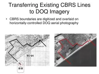
What are DOQ? • Digital Orthophotoquad (DOQ) - A raster data theme, built from scanned aerial photography, rectified and mosaicked to form a planimetrically correct map-like product. Used as a base for digitizing features, or as a realistic backdrop for maps. • Aerial photography of the Earth's surface, usually provided in GeoTIFF form, but also seen in other formats. A DOQ for a 7.5-min., 1:24000-scale quad is huge, thus the common use of DOQQs--digital orthophoto quarter quadrangles. • is a digital image of an aerial photograph in which displacements caused by the camera and the terrain have been removed. It combines the image characteristics of a photograph with the geometric qualities of a map.
What are .e00 files? • Data in .E00 is an ARC/INFO interchange file format. This is a simple ASCII file which can be opened and viewed using any common text editor (wordpad, notepad, textpad).
What are DEM? • Digital Elevation Model (DEM) - Any data theme that digitally represents terrain (the shape of the earth's surface); the most common structures being a raster grid of elevations, and the vector triangulated irregular network (TIN). • The USGS (United States Geological Survey) DEM (Digital Elevation Model) format describes raster elevation scans of the Earth's surface (essentially a specialized type of heightfield). • A digital representation of the elevation of locations on the land surface. A DEM is often used in reference to a set of elevation values representing the elevations at points in a rectangular grid on the Earth's surface.
Digital Terrain Model (DTM) • Digital Terrian Model(DTM) - A three-dimensional model of the Earth's surface, provided in digital form. • A term that describes a variety of digital formats for displaying or analyzing elevation information. A DEM is one of these formats.
Digital Raster Graphics (DRG)? • DRG is a scanned image of a US Geological Survey (USGS) standard series topographic map, including all map collar information. The image inside the map neatline is georeferenced to the surface of the earth and fit to the Universal Transverse Mercator projection.
What is Digital Line Graphs (DLG)? • A vector file containing points, lines, and/or areas that represent roads, water bodies, topographic contour lines, public lands, and railroads. Each data layer comes in a separate file. The DLG format was created by the USGS.