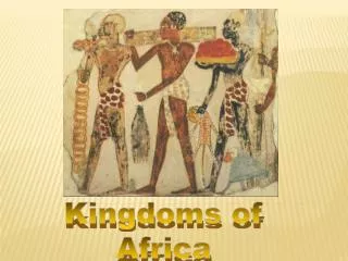
Kingdoms of Africa
600 likes | 3.07k Vues
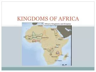
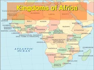
Kingdoms of Africa. A Satellite View. Great Rift Valley. 3,000 miles long. Tropic of Cancer 20 ° N. Africa: The “Tropical” Continent. Equator 0 °. Tropic of Capricorn 20 ° S. Vegetation Zones. Bantu Migrations.

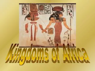
Kingdoms of Africa
E N D
Presentation Transcript
Great Rift Valley 3,000 miles long
Tropic of Cancer 20° N Africa:The“Tropical”Continent Equator 0° Tropic of Capricorn20° S
Bantu Migrations • The most prominent event in Sub-Saharan Africa during ancient times were the migrations of the Bantu-speaking peoples and the establishment of agricultural societies in regions where Bantu speakers settled. • Just as Sudanic agriculture spread to the Nile and provided an economic foundation for the development of many African societies, it also spread to most other regions of Africa south of the Sahara and supported the emergence of distinct tropical agricultural societies.
The Bantu • Located initially in the lower Niger Valleys, the Bantu began to migrate from West Africa spreading their language, knowledge of iron production, and their experience with settled tropical agriculture. • Between 500 B.C.E. to 500 C.E., this migration would move Bantu innovations and inherited innovations throughout central Africa and onto to southern Africa.
Geographic Considerations • North- Mediterranean- access to trade- coastal mountains- land for agriculture • East- Rift Valley- some mountains- Indian Ocean • West- grasslands and some rainforest along the Niger river • Central - equatorial- Congo-only real rainforest • South- high plateau- temperate climate-savanna
African Kingdoms 800 C.E. -1600 C.E.
African Kingdoms • Ghana 750-1076 • Mali 1235-1610 • Songhay 1464-1612 • Great Zimbabwe 11th -15th C.E. • Swahili coast 12th -15th C.E. • Many of the dates for these kingdoms are still debated
Ghana Empire • The Ghana Empire or Wagadou Empire (existed c. 750-1076) was located in what is now southeastern Mauritania, Western Mali, and Eastern Senegal • It is believed to be the first of many empires that would rise in that part of Africa. It first began in the eighth century, when a dramatic shift in the economy of the Sahel area south of the Sahara allowed more centralized states to form. • The introduction of the camel, which preceded Arabs and Islam by several centuries, brought about a gradual revolution in trade, and for the first time, the extensive gold, ivory, and salt resources of the region could be sent north and east to population centers in North Africa, the Middle East and Europe in exchange for manufactured goods.
Ghana Empire • The empire owed much of its prosperity to trans-Saharan trade and a strategic location near the gold and salt mines. Both gold and salt seemed to be the dominant sources of revenue, exchanged for various products such as textiles, ornaments and cloth, among other materials. • Many of the hand-crafted leather goods found in old Morocco also had their origins in the empire. The main centre of trade was Koumbi Saleh.
The Kingdom of Ghana probably began when several clans of the Soninke people of West Africa came together under the leadership of a great king named Dinga Cisse. Ghana had few natural resources except salt and gold. They were also very good at making things from iron. Ghanaian warriors used iron tipped spears to subdue their neighbors, who fought with weapons made of stone, bone, and wood. http://www.imf.org/external/np/exr/center/mm/eng/mm_rs_01.htm
Ghana became a rich and powerful nation, especially when the camel began to be used as a source of transport. Ghana relied on trade and trade was made faster and bigger with the use of the camel. http://es.encarta.msn.com/media_461532998_761558787_-1_1/Caravana_de_camellos.html news.nationalgeographic.com/. ../salt/photo6.html
Ghana’s Economy & Decline • The taxation system imposed by the king (or 'Ghana') required that both importers and exporters pay a percentage fee, not in currency, but in the product itself. Tax was also extended to the goldmines. • In addition to the exerted influence of the king onto local regions, tribute was also received from various tributary states and chiefdoms to the empire's peripheral. • The empire began struggling after reaching its apex in the early 11th century. By 1059, the population density around the empire's leading cities was seriously overtaxing the region. • The Sahara desert was expanding southward, threatening food supplies. While imported food was sufficient to support the population when income from trade was high, when trade faltered, this system also broke down.
Islamic Mosque in Ghana blankbluesky.com/ travel/ghana/ After 700 AD, the religion of Islam began to spread over northern Africa. Muslim warriors came into Ghana and fought with the non-Islamic people there. This weakened the great civilization of Ghana. Local warriors then decided to break away from the power of Ghana and form their own local kingdoms. This ended many of the trade networks. This eventually weakened the civilization of Ancient Ghana.
Mali http://www.btsadventures.com/img/mosque.jpg
Mali Empire • The Mali Empire or Manding Empire or Manden Kurufa was a medieval West African state of the Mandinka from c. 1235 to c. 1610. • The empire was founded by Sundiata Keita and became renowned for the wealth of its rulers, especially Mansa Musa I. • The Mali Empire had many profound cultural influences on West Africa allowing the spread of its language, laws and customs along the Niger River.
Mali Empire • The Mali Empire flourished because of trade above all else. It contained three immense gold mines within its borders unlike the Ghana Empire, which was only a transit point for gold. • The empire taxed every ounce of gold or salt that entered its borders. • By the beginning of the 14th century, Mali was the source of almost half the Old World's gold exported from mines in Bambuk, Boure and Galam.
A powerful king named Sundiata ruled this area from around 1230-1255 AD. He led the people in conquering and expanding his kingdom to be as great as Ghana had been. Perhaps the greatest king of Mali was Mansa Musa (1312-1337). He developed the gold and salt trade of Mali and his kingdom became very powerful and rich. Mansu Musa: Lord of the Negroes of Guinea. (Photo courtesy of History of Africa)
Mansa Musa was a Muslim. He built many beautiful mosques or Islamic temples in western Africa.
In 1324, Mansa Musa made a pilgrimage or hajj to Mecca with 60,000 servants and followers and 80 camels carrying more than 4,000 pounds of gold to be distributed among the poor. Of the 12,000 servants, 500 carried a staff of pure gold. This showed his power and wealth to the other people he visited. Salt, Copper, Gold
When Mansa Musa died, there were no kings as powerful as he was to follow. The great kingdom of Mali weakened. Eventually a group of people known as Berbers came into the area and other people came up from the south to claim territory that was once part of the kingdom. Although Mali fell, another advanced African kingdom took its place, the Kingdom of Songhay.
Songhay http://www.exzooberance.com
Songhay Empire • The Songhai Empire, also known as the Songhay Empire was a pre-colonial African state centered in eastern Mali. • From the early 15th to the late 16th Century, Songhai was one of the largest African empires in history. • Its capital was the city of Gao, where a small Songhai state had existed since the 9th Century. Its base of power was on the bend of the Niger River in present-day Niger and Burkina Faso.
Songhay Economy • The Songhai economy was based on a traditional caste system. The clan a person belonged to ultimately decided their occupation. The most common castes were metalworkers, fishermen, and carpenters. Lower caste participants consisted of mostly non-farm working slaves, who at times were provided special privileges and held high positions in society. • At the top were nobleman and direct descendants of the original Songhai people, followed by freemen and traders. At the bottom were war captives and slaves obligated to labor, especially in farming. • Dogons, Tuareg, and others
This map was created in 1375. The same trade routes were used by the merchants of the Songhay kingdom. http://www.sfusd.k12.ca.us/schwww/sch618/Travelers/Catal_AtlasAfrica.jpg
The great Songhay leader, Sunni Ali saw that the kingdom of Mali was weakening and he led his soldiers to conquer the area. He began the kingdom of Songhay. He also set up a complex government to rule all the lands he had conquered. http://www.abcorpaffairs.com/gallery/
Many mosques were built of local materials. Sunni Ali died in 1492 CE. His son took over the rule of Songhay but he did not accept Islam as a religion. Islam was accepted as a religion by many people in northern Africa. One of Sunni Ali’s generals, named Muhammad Ture, overthrew the new king and made himself king of Songhay. Ture was a follower of Islam (Muslim) and so he made Islam the religion of his kingdom. http://www.thewoz.ca/ghana/_larabanga1.jpg
Songhay remained a rich and strong kingdom under Muhammad Ture’s rule. It had a complex government centered in the city of Gao, and great centers of learning. But later rulers were not as powerful. In the late 1500s, Morocco invaded Songhay to take its rich trade routes. Moroccans had a new weapon, the gun, and the army of Songhay did not. This led to the fall of Songhay. (Photo courtesy of African Origin of Civilization by Cheikh Anta Diop)
Songhay Society • Upper classes in society converted to Islam while lower classes often continued to follow traditional religions. Sermons emphasized obedience to the king. • Timbuktu was the educational capital. Sonni Ali established a system of government under the royal court, later to be expanded by Askia Muhammad, which appointed governors and mayors to preside over local tributary states, situated around the Niger valley. • Local chiefs were still granted authority over their respective domains as long as they did not undermine Songhai policy.
Decline • Following Dauoud's death, a civil war of succession weakened the Empire, leading Morocco Sultan Ahmad I al-Mansur Saadi to dispatch an invasion force under the eunuch Judar Pasha. • Judar Pasha was a Spaniard by birth, but had been captured as an infant and educated at the Moroccan court. After a cross-Saharan march, Judar's forces razed the salt mines at Taghaza and moved on Gao; when Askia Ishaq II (r. 1588-1591) met Judar at the 1591 Battle of Tondibi, Songhai forces were routed by a cattle stampede triggered by the Moroccans' gunpowder weapons despite vastly superior numbers. • Judar proceeded to sack Gao, Timbuktu, and Djenné, destroying the Songhai as a regional power. • Governing so vast an empire proved too much for the Moroccans, and they soon relinquished control of the region, letting it splinter into dozens of smaller kingdoms.
Great Zimbabwe http://www.exzooberance.com
Lost Kingdom • Great Zimbabwe, or "house of stone", is the name given to hundreds of great stone ruins spread out over a 500 km² (200 sq mile) area within the modern day country of Zimbabwe, which itself is named after the ruins. • The exact origin of the word Zimbabwe is not known.
Great Zimbabwe • Built consistently throughout the period from the 11th century to the 15th century, the ruins at Great Zimbabwe are some of the oldest and largest structures located in Southern Africa. • At its peak, estimates are that the ruins of Great Zimbabwe had as many as 18,000 inhabitants. The ruins that survive are built entirely of stone. • The ruins span 1,800 acres (7 km²) and cover a radius of 100 to 200 miles (160 to 320 km).
Great Zimbabwe • It is believed Great Zimbabwe located south of the Zambezi River was where much of Africa’s gold was mined. • At its peak in about 1400, the city which occupied 193 acres may have had 18,000 inhabitants. • Between 1250 and 1450, local African craftsmen built stone structures for Great Zimbabwe’s rulers, priests, and wealthy citizens.
Great Zimbabwe • The largest structure served as a king’s court. • Mixed farming and cattle-herding was Great Zimbabwe’s economic base. • Long distance trade mostly in gold • Ecological crisis caused from overgrazing and the destruction of forests may have led to their decline.
Great Zimbabwe • While there is little known about Great Zimbabwe, its size and influence on the region is just recently being rediscovered. • European disbelief in a Bantu-speaking empire is still under debate in some academic circles. • The European belief that Africans were not capable of such an advanced kingdom fueled the speculation of the kingdom as a lost kingdom of some White nation perhaps the Queen of Sheba.
Swahili Coast http://www.exzooberance.com
Swahili coast • 1800 miles long • Diffusion from Indian, Arab, Chinese, and others • Islam perhaps most enduring
Swahili Coast • While the Swahili Coast had kingdoms, it was not controled by just one kingdom. • The region was a center hub of trade and commerce in east Africa. • The introduction of various traditions such as Islam helped to shape the character of the Swahili Coast.