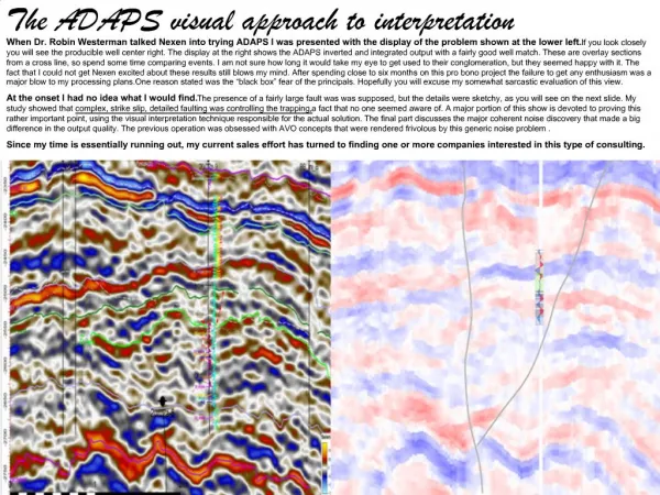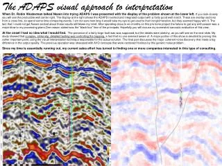
Photo Interpretation (Visual)
Photo Interpretation (Visual). Overview. Data that can be derived from Aerial Photo Photo interpretation (Visual) Difference Examples of Difference Interpretive elements 3D Types of interpretation Guides to interpretation Summary of Photo Interpretation.


Photo Interpretation (Visual)
E N D
Presentation Transcript
Overview • Data that can be derived from Aerial Photo • Photo interpretation (Visual) • Difference • Examples of Difference • Interpretive elements • 3D • Types of interpretation • Guides to interpretation • Summary of Photo Interpretation
Data that can be derived from Aerial Photo • Distance (using ruler and scale of the photo) • Angel (using protractor - Direction) • Areas • Height (3D – contour using stereoscopy) • Extraction of natural and artificial features
Photo Interpretation • Interpretation is based upon the concept of differentiation - the ability to identify a single element due to its difference with respect to background and/or surroundings • Difference can be "measured" in three responses: spatial, spectral, and temporal • Visual interpretation is dependent on the skill of the operator, experience, and knowledge of the area • Automatic classification (Digital) is based on using computers instead of human eye
Difference • Spatial: related to dimension or location (includes size, shape, position, association) • Spectral: EM response (tone, colour as a result of reflection and emitted EM energy) • Temporal: change in spatial or spectral characteristics with time. Can be cyclic (daily, seasonal, annual) or "permanent" (eg. clearing, construction)
Examples of Difference • Object is big in size spatial Suitable image scale ? • Water is similar to vegetation in Black & White imagery from the visible band (dark tone) but different in the Near Infra Red spectral Portion EM spectrum to sense in ? • In late summer, crop based agricultural activity is minimal due to the dry conditions. By spring crops are reaching their prime temporal what time scale / point is best to identify a specific feature ?
Key interpretive elements • Primary: Size, Shape, Tone, Texture, Pattern • Additional: Site / Location, Association, Shadows, Stereoscopic Appearance
Interpretive elements • Shape: General form, configuration or outline of individual objects, eg. regular, irregular, linear, curved, rounded, triangular etc. e.g. House, Round About • Size: The physical extent or dimension of a feature. May be comparative (relative) (eg. a big bird is still small compared to an elephant). • Comparable: Large, small, massive, tiny • Magnitude: kms, metres, microscopic, macroscopic • Tone: Relative brightness or colour of a feature • Gray scale:very dark tone, dark tone, dark gray, mid tone, light tone, white • Colour: Blue, Green, Red, etc.
Interpretive elements-continue • Pattern: Relates to the spatial arrangement of objects. Repetition of form or spectral response (tone) eg. gridded, regular (plantation), linear, irregular, ordered (hierarchal), symmetric, geometric etc. e.g. Agriculture, Orchard, Forest • Texture: Frequency of tonal change of the object eg. smooth, coarse, speckled, fine, fuzzy, soft.e.g. water appears as smooth while forest as coarse • Site/Location: physical position of object feature (topographic or geographic), hill slopes, ocean, land, mountains etc.
3D • Monoscopic (easier and quicker, flat area) versus Stereoscopic (number of photos, cost, purpose) • Shadow: Used to determine 3D information from a 2D image, shape and height of object via shadow • Shadows can enable objects to be "seen" when the natural conditions may not be favourable eg. power poles (small planimetric extent, can only be identified by shadow), sand dunes (shadows result in contrast, can see topographic outline) • Appearance: How the surface appears in 3D, generally related to surface consistency and change in height, eg. Object (Tall, spherical) and Area (Undulating, flat, rugged)
Types of interpretation • Generally there are two types of interpretation: • Selective (Descriptive, graphical, pictorial, sample images) • Elimination (Dichotomous) • The selective method provides the interpreter with a range of choices with accompanying information or descriptions (eg. feature characteristics such as tone, shape, texture etc). The interpreter simply refers to the object and then selects the choice that best matches that seen (eg. pictorial/graphical, sample images, descriptive text) • The elimination method uses a structured "routing" process to reduce the classification to a minimum number of options (ideally only one). Usually simple 2 path decision making tree with only minor decisions to be made at each step
Guides to interpretation • Define the objective of the interpretation:Simple (feature recognition) and complex (modeling) • Identify the type of photos needed (B/W, Color_IR, Stereoscopic vs Monoscopic coverage, Temporal, Scale, Calibration / enhancement / rectification) • Prepare an equipment that aid in interpretation e.g. magnifying lens, stereoscope - mirror stereo, pocket stereo, and digital visual system • Have a good eyes, lateral thinking, and patience • Acquaint yourself with the area: Knowledge of phenomenon and area: general, local, specific • Follow a deductive process: general examination of the image and concentration on specific features • Check the consistency and reliability of interpretation by maps and ground truth data (Accuracy)
Summary of Photo Interpretation • Features on a photo can be delineated based on the following characteristics: • Tone (B/W -gray shade), color and brightness) • Size (depend on scale e.g. size of house) • Shape (geometrical arrangement, road/house) • Texture (smoothness or roughness,water, grass) • Pattern (spatial arrangement, network of streets) • Shadow (height of object) • Site (geographic location, features on rivers) • Photo interpretation can be supported by magnifying lens and stereoscope (pocket, mirror)
Photogrammetric Applications • 3D analysis for environment 3D analysis enables users to create, analyse, and display surface data, which is important in many applications in the urban areas, for example, road, canal, dam, and simulation of air and water pollution. 3D data can be extracted from aerial photo directly (stereoplotters) which allow Photorealistic presentation with possibilities for navigation through the 3D city model (fly through) and animate on-screen designs • Urban Growth Tracing socio-economic and physical pattern of urban development overt space and time is a key element for heritage and future development. Historical aerial photographs imagery can be classified and integrated with GIS to show the historical development of a city