Tsunami Disaster Mitigation System in Japan
280 likes | 1.27k Vues
Tsunami Disaster Mitigation System in Japan. Bitter Tsunami Experienced Tsunami Warning and Mitigation System Outline of Disaster Management System New Challenges against Tsunamis. 1. Historical Damaging Tsunamis along Japanese Coast (in last 150 years).

Tsunami Disaster Mitigation System in Japan
E N D
Presentation Transcript
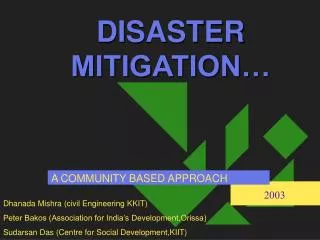
Tsunami Disaster Mitigation System in Japan • Bitter Tsunami Experienced • Tsunami Warning and Mitigation System • Outline of Disaster Management System • New Challenges against Tsunamis 1
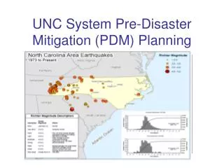
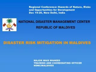
Historical Damaging Tsunamis along Japanese Coast (in last 150 years) 1) The number includes dead or missing from earthquakes. 2) Tsunami generated at far off Japanese coast. 8
TSUNAMI WARNING Tsunami Signboard TSUNAMI WARNING Tsunami Warning System Elements Communication & Transmission of Tsunami Warning to Localities & Civil Defense Authorities Local government Central Government TSUNAMI WARNING Radio TV/Radio Station TV(Telops, Warning maps) 13
NHK TV Screen Image showing Seismic Intensity by Miyagi-ken Earthquake on 26 July 2003 within 5 minutes after the Earthquake with/without Tsunami Warnings 15
Promoting Basic Knowledge about “TSUNAMI” Disaster + Safe Evacuation Route Early Warning = Understanding of Hazardous Areas Appropriate Risk Awaweness of Local Communities Safe Evacuation 16
Pictogram on Tsunami Tsunami Hazard Area Tsunami Evacuation Area Tsunami Evacuation Building Building for evacuation against Tsunami. Safe place/hill for evacuation against Tsunami. There is a high possibility to be flooded in this area when earthquake occurs. 21
Sign of Previous Tsunami Height (2) Inundated level of previous Tsunami 23
Tsunami countermeasures taken by local municipalities and communities (1) Group session on evacuation plan (Urado-District, Kochi Pref.) Evacuation drill on Tsunami (Taro Town, Iwate Pref.) 25
Tsunami countermeasures taken by local municipalities and communities (2) Training for supplying food (Yawatahama-city, Ehime Pref.) Check of the dangerous points (Nansei-Town, Mie Pref.) 26
Tsunami countermeasures taken by local municipalities and communities (3) Drill for disaster management with maps (Hyga-city, Oita Pref.) Meeting on the disaster map (Bungo-Takada-city, Oita Pref.) 27
Tsunami Hazard Maps Purpose • Identifying and showing vulnerable areas - Enhancing people’s awareness ・Showing information on disaster risks and evacuation routes, etc. ・Letting residents in coastal areas and visitors know the hazard map through various opportunities ・Tsunami drills Tsunami Hazard Map(Susaki City) National Government prepared a guideline for help local authorities to make and use hazard maps. 28
Japan and its major seacoasts Chishima Trench Japan Trench 200 km 400 km 600 km 800 km 1,000 km Suruga Trough Seismic areas for reinforcing and promoting disaster reduction measures related to the Tokai, Tonankai and Nankai Earthquakes Nankai Trough District (undesignated) for promoting seismic disaster reduction measures related to earthquakes along the Japan Trench and the Chishima Trench 48
Possible large-scale earthquakes and tsunamis in Japan Tokyo Inland EQ Tokai EQ Tonankai & Nankai EQ Japan Trench & Chishima Trench EQs 49
Estimation of damage caused by possible EQs (by technical investigation committees of Central Disaster Management Council) Tonankai Nankai EQ Tokai EQ Kobe EQ 1995 (Maximum cases) 9,200 (7,900 by strong tremors) 18,000 (8,600 by tsunamis) Victims (persons) 6,436 Houses destroyed 260,000 360,000 105,000 Economic loss (billion yen) 37,000 57,000 10,000 51
Earthquake Disaster Risk Reduction Strategy (formulated by Central Disaster Management Council on 30 March 2005) Setting an overarching goal for disaster risk reduction in the next decade To halve the estimated death toll and economic loss Tokai EQ • Death toll : 9,200 persons → 4,500 • Economic Loss : 37 trillion yen → 19 trillion yen ☆Strategic goal (ex.) - Increase the ratio of retrofitted houses : 75% (2003) → 90% (2015) Tonankai & Nankai EQ • Death toll : 17,800 (8,600 by tsunamis) → 9,100 • Economic Loss : 57 trillion yen → 31 trillion yen ☆Strategic goal (ex.) - Every municipality at risk is expected to develop hazard maps in 2015 54
Police, Firefighting, Self-defense Force Families Neighbors Communities – last resort Need to build communities resilient to disasters, including through enhancing public awareness and developing hazard mapping How the affected people were rescued in case of Great Hanshin-Awaji EQ? approx. 35,000 persons 23% 77% 55
THANK YOU 56