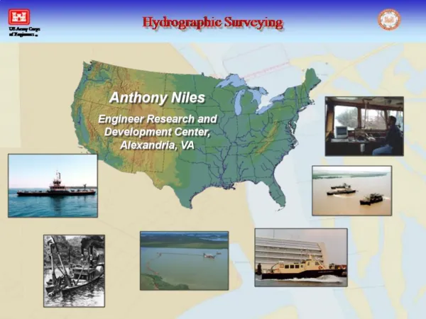
Anthony Niles, Program Manager ERDC-TEC
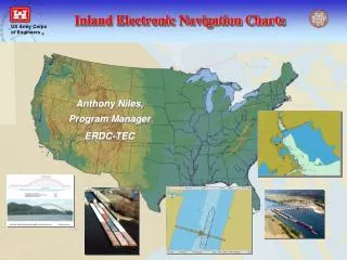
Anthony Niles, Program Manager ERDC-TEC. IENC coverage completed, published and maintained; 56 cells covering 4,225 miles IENC coverage under development; 1,250 miles 2,520 miles remaining. IENC Coverage. Ohio River at Pittsburgh. IENC Project Delivery Team

Anthony Niles, Program Manager ERDC-TEC
E N D
Presentation Transcript
Anthony Niles, Program Manager ERDC-TEC
IENC coverage completed, published and maintained; 56 cells covering 4,225 miles • IENC coverage under development; 1,250 miles • 2,520 miles remaining IENC Coverage Ohio River at Pittsburgh
IENC Project Delivery Team • ERDC-TEC, Manager, Tony Niles • New Orleans, MVD Lead, Ralph Scheid - Louisville, LRD Lead, Denise Ladue • Memphis, Jennifer Redden • Huntington, Greg Jones • Rock Island, Jim Aidala • Nashville, Wayne Ligon • St. Louis, Bob Mesko • Pittsburgh, Steve Leblanc • St. Paul, Paul Machajewski • Vicksburg, Cliff Geter - Little Rock, SWD Lead, William Penn • Mobile, Hal Gates • Tulsa, Larry Prestien • ERDC-CHL, Michael Winkler • U.S. Coast Guard, NAVCEN and 8th District • University of New Hampshire, consultant • 3001, Inc / IIC International, contractor • Photo Science Inc, contractor IENC Team
FY06 Project Structure Project
Status: USCG procuring chart systems for river tenders to enable buoy data collection – contract had to be re-competed. • Problem: Cumberland cells require buoys for publication; no other feasible way to delineate channel. • Solution (temporary): Buoy survey from Corps vessel, with USCG approval, used to chart buoys. Coast Guard Coordination - Buoys Cumberland River
COAST GUARD AND MARITIME TRANSPORTATION ACT OF 2004 SEC. 410. ELECTRONIC CHARTS. Mandates carriage of electronic charts by several classes of vessels operating in U.S. waters, including towing vessels over 26 ft overall length and at least 600 horsepower. • Issues to be resolved with Coast Guard and NOAA; • will commercial IENCs be certified to meet carriage requirements? • who will certify non-government charts? • will certification process be the same as with NOAA ENCs? • are display and performance standards needed? • *** Issues must be resolved by January 2007 – deadline for USCG rule! Coast Guard Coordination - Buoys
Features likely to change more than once a year; Buoys Updating Fixed Aids to Navigation Contours/Depth Areas Sailing Line
U35LM601.000 U35LM716.000 U35LM829.000 U35LM601.001 U35LM716.001 U35LM829.001 U35LM601.002 U35LM716.002 U35LM829.002 U35LM601.003 U35LM829.003 U35LM829.004 FY06 Update Plan Begin production of S-57 updates for some areas, testing contract and in-house capabilities. Updating • In-House: LRL and TEC to perform ongoing updates for Ohio, Cumberland, and Green using district field data and Notices to Mariners • Contract: 3001/IIC to perform ongoing updates for Mississippi, Red, Illinois, Atchafalaya, BWT using district field data and USCG Notices to Mariners Beyond FY06: Most likely, majority of cell updates to be performed by contract, with some in-house activities to retain expertise.
Coastal Channel Framework • Complete and accurate reference for all coastal and Great Lakes channels, • FY05: Data received from 14 districts; errors and spatial inconsistencies resolved for three districts; assisted NOAA with specific data requests. Coastal Data
Corps District Sample channel discrepancy between NOAA chart and Corps data Coastal Data NOAA ENC • FY06: Continue “fixing data” and building channel framework using SAM expertise gained with e-Coastal initiative.
SMARTLOCK • Instrumented Locking System for Inland Waterway Navigation; enables all-weather transit • requires sub-meter accuracy for lock transit • USACE establishing RTK GPS broadcast at upper 3 locks on the Ohio • IENCs currently 2m (95% CEP) accuracy for fixed structures, including locks; • IENC refined for SMARTLOCK test areas Port of Pittsburgh and SMARTLOCK partner now seek an operational system, with the Corps providing; IENC Application - SMARTLOCK • 1 foot chart accuracy for all locks on Ohio, Mon, Kanawha (32 Locks), • RTK GPS broadcast for all Ohio, Mon, Kanawha locks.
Shoaling overlays developed during extreme low water conditions on Ohio in August; demonstration on Coast Guard river tenders and industry vessels being pursued. IENC Application - Low Water Surveys Lower Ohio River
Cooperative Charting Agreement With U.S. Power Squadron U.S. Power Squadron, recreational boating organization promoting safety, is to perform field checks and report errors or inaccuracies in IENCs, similar to the cooperative charting arrangement with NOAA. Field checks and observations to include the following features: Partnership - U.S. Power Squadron Revetment Boat ramp Mooring facility Wrecks Day mark Ferry route Non-navigable river or tributary Land Region Bridge Overhead pipeline Light Overhead cable Permanently moored vessel Storage tank Support pylon River Gauge Marina Dock/wharf Conveyor Marine fender Submarine cable
Oct 05 - IEHG completes harmonized Inland ENC Data Standard, based largely on USACE Encoding Guide • IEHG document formally released at COMPRIS Conference in Rotterdam, • IEHG document is now a model Inland ENC Register, with broader participation invited, • Inland ENC Register to be incorporated into S-100 under the International Hydrographic Office International Coordination
The Revolting Dredgers …………………….. An update; • Origin: meeting was held 26 May at Corps HQ to discuss hydrographic survey standards issues raised by dredging and survey contractors. • Summary: dredging contractors frustrated over non-standard, ambiguous, and incorrect hydro survey practices in support of dredging among Corps offices, with both in-house surveys and contract specifications; majority of issues arose from Corps districts not specifying or not following Hydro Survey EM. • First Step: contractors and Corps personnel agreed to dialogue the issues and propose solutions through the new Hydro Survey Community of Practice (HSCoP). • Result: The HSCoP discussed issues at the annual Multibeam Users Group Meeting, 3 Nov. and generally concluded; • contract specs sometimes poorly written and/or poorly enforced, • some incorrect or contradictory guidance in the EM, • continual update and maintenance of the EM needed, • HSCoP personnel MUST BE INCLUDED in dredging meetings. Hydro Survey CoP