Download
1 / 1
10 likes | 257 Vues
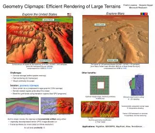
Geometry Clipmaps: Efficient Rendering of Large Terrains. Frank Losasso Hugues Hoppe Microsoft Research. Explore Mars. Explore the United States. Mount Rainier. Gusev Crater. Ma'adim Vallis. Olympic Mountains. Conterminous 48 states at 30m spacing (216,000 93,600 = 20G samples)

E N D
Geometry Clipmaps: Efficient Rendering of Large Terrains Frank Losasso Hugues HoppeMicrosoft Research Explore Mars Explore the United States Mount Rainier Gusev Crater Ma'adim Vallis Olympic Mountains Conterminous 48 states at 30m spacing (216,000 93,600 = 20G samples) [from US Geological Survey (USGS)]compressed from 40GB to 350MB Full planet at 128 samples/degree (46,080 22,528 = 1G samples)[from Mars Orbital Laser Altimeter (MOLA) of Mars Global Surveyor]compressed from 2GB to 23MB • Challenges: • Concise storage (within system memory) • Fast rendering (60 frames/sec) • Visual continuity (no pops) Other benefits: • Solution: geometry clipmaps: • Store terrain as a compressed image pyramid (100x savings) • Render nested regular grids about the viewer • Blend the grid levels using transition regions (fast GPU programs) Optimal triangle strips; batched primitives 60M/sec Efficient view-frustum culling ~3X speedup Incrementally computed normal maps inexpensive shading Same LOD framework on textures seamless, tile-free texturing A very coarse geometry clipmap Transition regions (blue), and z-based coloring Zero detail Synthesized detail • As the viewer moves, the clipmap is incrementallyrefilled using either: • regionally decompressed terrain (PTC image decoder) or • fractal synthesis (to invent detail at infinite resolution) • It’s all done on-the-fly Runtime geometry amplification “free” detail Applications: FlightSim, MMORPG, MapPoint, Atlas, TerraServer, …