Piloting – Compass & Degrees, Chart Plotting, & Relative Bearings
870 likes | 2.48k Vues
Piloting – Compass & Degrees, Chart Plotting, & Relative Bearings. Ordinary Requirement 9 Part I. Requirements. Explain the degree system of compass direction. Explain variation and deviation, and show how corrections are applied to correcting and uncorrecting compass headings.

Piloting – Compass & Degrees, Chart Plotting, & Relative Bearings
E N D
Presentation Transcript
Piloting – Compass & Degrees, Chart Plotting, & Relative Bearings Ordinary Requirement 9Part I
Requirements • Explain the degree system of compass direction. Explain variation and deviation, and show how corrections are applied to correcting and uncorrecting compass headings. • Name relative bearings expressed in both degrees and points. Be able to report objects in view and wind directions with respect to the boat, and know the duties of a lookout. • Name three kinds of devices used aboard ship for measuring speed and/or distance traveled and, if possible, demonstrate their use. • Make a dead reckoning table of compass and distances (minimum three legs) between two points, plot these on a chart, and determine the final position. • References • “Mariners Compass”, p. 171 Ordinary 9 - Piloting
Description • The presentation covers Compass, Plotting a Course, Relative Bearings & Lookout Duties • See also: • Piloting 9b – Navigation Instruments Ordinary 9 - Piloting
Mariner’s Compass • "Mariner's Compass" is generally taken to mean the magnetic compass. • Historically, it meant the division of the Circle of the Horizon into 32 points. • These points are the directions or rhumbs of the wind. • Thus, a rhumb-line is the direction followed by a ship sailing on a straight course. Ordinary 9 - Piloting
Degree System of Direction 90°N • Earth is round not flat • 360 degrees in a circle • 60 minutes in a degree • 60 seconds in a minute • Divide the Earth • Parallels (Latitude) • 0° to 90° North and South • Meridians (Longitude) • 0° to 180° East and West 0° (Equator) 90°S 180° 90°E 90°W 0° (Prime Meridian) Ordinary 9 - Piloting
Latitude and Longitude • Latitude • Parallels • always written first • labeled North or South • 1 degree = 60 NM • 1 minute = 1 NM • Longitude • Meridians • Labeled East or West • Degrees vary in length depending on latitude. Ordinary 9 - Piloting
Examples of Locations • Kemah Channel Outer Marker • Lat: 29°33.1’ N • Lon: 94°59.5’ W • ‘I’ Pier, Lakewood Yacht Club • Lat: 29°33.6’ N • Lon: 95°01.9’ W Ordinary 9 - Piloting
Compass Variation • A compass does not normally point to true north. • The direction in which the compass needle points is referred to as magnetic north • The angle between magnetic north and true north is called magnetic variation. • East of a line from Ohio to Georgia, variation is West (+) • West of that line, variation is East (-) • Usually read from chart (bottom or compass rose) Ordinary 9 - Piloting
Compass Variation • Variation does not remain constant in time. • Complex fluid motion in the outer core of the Earth causes the magnetic field to change slowly with time. • This change is known as secular variation. Ordinary 9 - Piloting
Compass Variation • Variation changes with time in an unpredictable manner. • Variation shown on old topographic, marine and aeronautical charts need to be updated if they are to be used without large errors. • Annual change corrections cannot be applied reliably if the maps are more than a few years old Ordinary 9 - Piloting
Magnetic Deviation • Magnetic deviation is the second correctable compass error. • Deviation is caused by magnetic forces within your particular boat • Deviation varies for each boat. • Metal objects, such as an engine or an anchor, can change magnetic forces. • Stereo, speakers, and other electric equipment or wiring, if too close to the compass, can introduce large errors in compass heading. Ordinary 9 - Piloting
Magnetic Deviation • Deviation changes with heading, resulting in a deviation table or deviation chart (shown below). • The vertical axis states the correction in degrees. • The horizontal axis states the ship's heading Ordinary 9 - Piloting
Deviation Table Ordinary 9 - Piloting
Magnetic Deviation • Compensation • When a compass is newly installed it often shows larger deviations then this and needs coarse compensation by carefully placing small magnets around the compass. • It is the remaining error that is shown in your deviation table. • Swinging the boat • Determine deviation by placing your boat in the line of a pair of leading lights and turning her 360 degrees. Ordinary 9 - Piloting
T M C Var. Dev. Variation and Deviation • Three types of 'North' • True (T) • Magnetic (M) • Compass (C) • Three types of courses • True Course (TC) • Magnetic Course (MC) • Compass Course (CC ) • All are related by deviation and variation. Ordinary 9 - Piloting
Converting a true course into a compass course: TVMakes Dull Children True Variation Magnetic Deviation Compass TC + VAR = MC + DEV = CC Converting a compass course into a true course: Can Dead Men Vote Twice Compass Deviation Magnetic Variation True CC - DEV = MC - VAR = TC Compass Correction Ordinary 9 - Piloting
Compass Correction for Variation • If we sail a true course of 090° on the chart with a variation of 3° East, what is the magnetic course? • Remembering T+V=M gives: T 090° + V+ (-3°E) = M = 087° • Remember, by convention: East is Least (-) West is Best (+) Ordinary 9 - Piloting
Correcting for Variation • Convert a magnetic course of 225° with a variation of 3°E into a true course • First, rearrange T + V = M to give M – V = T M 225° - V- (-3°E) = T = 228° • Remember, by convention: East is Least (-) West is Best (+) Ordinary 9 - Piloting
Correcting for Variation and Deviation • For a true course of 170°, and using the deviation table in this presentation, and a variation of 15°W, what is the compass course? Ordinary 9 - Piloting
Correcting for Variation and Deviation • For a true course of 170°, and using the deviation table in this presentation, and a variation of 15°W, what is the compass course? T 170° + V+ 15°W = M = 185° + D+ (-3°E) = C = 182° Ordinary 9 - Piloting
Correcting for Variation and Deviation • For a compass course of 020°, and using the deviation table handout and a variation of 15°W, what is the true course? Ordinary 9 - Piloting
Correcting for Variation and Deviation • For a compass course of 020°, and using the deviation table handout and a variation of 15°W, what is the true course? C 020° - D- 4°W = M = 016° - V- 15°W = T = 001° Ordinary 9 - Piloting
Compass Rose • The orientation of a map or chart is shown by a compass rose; • May show just north, or it might show many points of the compass or degrees. • May also show a true compass (outer) rose and a magnetic compass (inner) rose. Ordinary 9 - Piloting
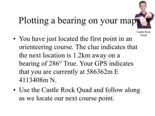
Charts and Direction • To measure direction use a parallel rule. • Example: • Find the course direction from buoy A to buoy B. Ordinary 9 - Piloting
Charts and Direction • First align a parallel rule with the two positions A and B to establish a line of position (LOP). • Then move one leg of the parallel rule at a time walking the rule to the compass rose without losing the alignment. • Finally, when one of the rules is aligned with the heart of the compass rose, you can read course A-B. • In this example: 153°. Ordinary 9 - Piloting
Course Plotting • Plot of ships progress based on • Course (assume true unless otherwise noted) • Speed (in knots) • Time traveled • Known starting point (fix) • Checked and plotted every hour at a minimum • Checked and plotted at every course or speed change Ordinary 9 - Piloting
Terms • DR Dead Reckoning Position • EP Estimated Position • Fix • LOP Line of Position • C Course • S Speed Ordinary 9 - Piloting
Start from a fix Label all lines on chart Numbers are rounded off Use Military time Courses & bearings are 3 digits (045, 218) Label course with C & bearing with B (C045) Speed is in Knots placed under the course line Distance to nearest 1/10 NM place after speed DR position is marked by a dot and semicircle Fix is marked by a dot and circle with the time Estimated position marked by a dot and box To Plot a Course Ordinary 9 - Piloting
Labeling Plots FIX GPS FIX DR C083 1630 1600 1700 S8.4 D3.6 Ordinary 9 - Piloting
Plotting Example Ordinary 9 - Piloting
Using the 1998 Bowditch Bay chart and your deviation table handout, you depart from the R N “2” Nun buoy outside Perkins Cove at 0900 on a course to R “10” Q R on the left side of Channel Island. Plot your new course and label the course heading. What is your compass course to R “10” Q R ? T 287° + V + 15°W = M = 302° + D + (-2°E) = C = 300° Plotting Practice Ordinary 9 - Piloting
You arrive at R “10” Q R at 1124. Depart immediately for R N “4” on the Shark River channel. Plot your new course and label the course heading. What is your compass course to R N “4” ? T 307° + V + 15°W = M = 319° + D + 0°W = C = 319° Plotting Practice Ordinary 9 - Piloting
You arrive at R N “4” at 1236. Depart immediately for RW “OR” on the Oyster River Range, arriving at 1437. Plot your new course and label the course heading. What is your compass course to RW “OR” ? T 145° + V + 15°W = M = 160° + D + (-2°E) = C = 158° Plotting Practice Ordinary 9 - Piloting
Measuring Distances • To measure distances on a chart use dividers. • For short distances, put one point on each end. • For long distances: • First, take a 'nice' distance like 1' (1 nm) or 5 ' (5 nm) on the chart scale or use the left and right edges (latitude). • NEVER use the top/bottom edges (longitude). • Then, start walking with the dividers from one spot to the other. • Finally, adjust the dividers to measure the small remainder at its own latitude. Ordinary 9 - Piloting
Calculating Distances • Now measure and label the distances of the legs you plotted on your chart. • What is the distance from R N “2” outside Perkins Cove to R “10” Q R? • 12.0 nm • What is the distance from R “10” Q R to R N “4” on the Shark River channel? • 7.8 nm • What is the distance from R N “4” to RW “OR” on the Oyster River range? • 8.1 nm Ordinary 9 - Piloting
Speed Time Distance Speed (knots) Distance (NM) = 60 (minutes) Time (minutes) Ordinary 9 - Piloting
Speed Time Distance 60 × Distance Speed = Time 60 × Distance Time = Speed Speed × Time Distance = 60 Ordinary 9 - Piloting
Speed and Distances • Now calculate and label your speed from the distances of the legs you plotted on your chart. • What is your speed from R N “2” outside Perkins Cove to R “10” Q R? • 5.0 knots • What is your speed from R “10” Q R to R N “4” on the Shark River channel? • 6.5 knots • What is your speed from R N “4” to RW “OR” on the Oyster River range? • 4.0 knots Ordinary 9 - Piloting
Dead Reckoning • Now calculate and label the DR positions on your course every hour on the hour.. • Plot 2 DR positions on the first leg at 1000 and 1100 • Plot 1 DR positions on the second leg at 1200 • Plot 2 DR positions on the third leg at 1300 and 1400 Ordinary 9 - Piloting
Deck Log • Now enter the fixes and DR positions into your deck log. • Complete each compass entry and latitude and longitude • Measure longitude and latitude to nearest parallel or meridian using dividers. Ordinary 9 - Piloting
Relative Bearings • The bearing of an object with respect to the fore-and-aft line of the ship is the relative bearing. • Relative bearings can given in degrees or divided into 32 points (11.25 degrees per point). Ordinary 9 - Piloting
Example • You should be able to translate from compass to relative bearings easily. • Your ship is headed south (on a true course of 180) • You sight a ship on your starboard beam with a relative bearing of 090 • The true bearing of the sighted ship is 270: (180 + 090 = 270) Ordinary 9 - Piloting
Relative Bearings On the Starboard Beam Dead Ahead Dead Astern On the Port Beam Ordinary 9 - Piloting
On the Starboard Beam Broad on the Starboard Bow Broad on the Starboard Quarter Dead Ahead Dead Astern Broad on the Port Bow Broad on the Port Quarter On the Port Beam Relative Bearings Ordinary 9 - Piloting
Relative Bearings On the Starboard Beam Broad on the Starboard Bow Broad on the Starboard Quarter 1 2 3 3 2 1 Dead Astern Dead Ahead Broad on the Port Bow Broad on the Port Quarter On the Port Beam Ordinary 9 - Piloting
Relative Bearings Ordinary 9 - Piloting
Duties of a Lookout • The rules of the road require a vessel to keep a proper lookout. • In fog or at night, at least one lookout forward and one aft. • A lookout is required even at anchor or backing out of a slip. Ordinary 9 - Piloting
Duties of a Lookout • Must be vigilant, have no other duties, and be in a position to see and hear best. • Must relate other evident pertinent information such as distance, course, and speed. • In order to communicate an object’s location, you must know and give the relative bearing of the object. Ordinary 9 - Piloting
Duties of a Lookout • The lookout must be able to report accurately • the range and bearing of any vessels • aids to navigation, and • objects sighted or heard. Ordinary 9 - Piloting