Download
1 / 20
200 likes | 343 Vues
Authoritative Location Data for DoD Business Missions. Lora Muchmore Director Business Enterprise Integration Directorate ODUSD(I&E) December 4, 2007. Defense Basing Space “The DoD Footprint”. Major Elements of The DoD Footprint.

E N D
Authoritative Location Data for DoD Business Missions Lora Muchmore Director Business Enterprise Integration Directorate ODUSD(I&E) December 4, 2007
Major Elements of The DoD Footprint What Major Assets or Effects Define Our Common Installation Picture? • I&E Assets • Real Property Sites • Owned Land • Less-than-fee • Outgrants • Airspace • Special Use • Restricted • Training Routes • Seaspace I&E Liabilities • Environmental Liabilities • Air Accident Potential Zones • Noise Zones • Explosive Safety Quantity- Distance Arcs • Range Spectrum Requirements Quantitatively and qualitatively comprise the “footprint” or “basing space”for DoD activities in support of the Battle Space
Where am I? What’s around me? Location Defined Where’s my stuff? Absolute versus Relative
Challenges Today • Association of people and equipment to location • Many different sources of location data/standards • GEOLOCs • DoDAACs • Installation Codes • DMDC location codes • UICS • Data integration • Accuracy problems • Costly • Timely
Initiative Drivers • Initiatives • President’s Management Agenda (PMA): obtaining a clean (unqualified) financial audit opinion is basic prescription for well-managed organization • Executive Order 13327: Promotes efficient and economical use of Federal government’s real property assets • Establish the Senior Real Property Officer at all major landholding agencies • Direct the Senior Real Property Officers to develop and implement agency asset management plans • Create the interagency Federal Real Property Council • Authorize the development of a single and descriptive database of federal real properties • Joint Financial Management Improvement Program (JFMIP): Agreed with PMA requirement for clean financial audit but added: • Being able to routinely provide timely, accurate, and useful financial and performance information • Having no material internal control weaknesses or material noncompliance with laws and regulations • Meeting requirements for Federal Financial Management Improvement Act of 1996 • DoD Net-Centric Data Strategy • Established DoD Metadata Registry • Required establishment of Communities of Interest
Real Property Enterprise Systems • Real Property Unique Identifier Registry • Unifying disparate real property systems and DoD information needs through the use of a strong linking mechanism • RPUID is the key element in the real property inventory that distinctly and uniquely identifies a parcel of land, building, or other real property improvements in which the Department has a legal interest • RPUID allows related data from across the spectrum DoD business areas to be linked to specific asset records • Real Property Assets Database • Central repository of DoD RPI data • Net-centric data warehouse with multi-tiered SOA • Uses Military Departments’ and WHS’ authoritative RPI databases as data sources and is used to populate a variety of real property resourcing predictive data models • Make annual reports on agency real property inventory data to OMB and GSA
To Be UID Environment Enterprise Visibility Accountability Value Organization Acq Program Location Status Disposition Formal Ad Hoc Budget ACAT Absolute Relative Condition AT&L/P&R PA&E AT&L CJCS/P&R/AT&L CJCS/P&R/AT&L Property (AT&L) People (P&R) Real Property Personal Property Person Role AT&L P&R RPUID IUID FMID EDIPI
Installation Geospatial Information and Services (IGI&S) databases to include Real Property Unique Identifiers for sites and assets. Registry search links results with mapping portal. Authoritative geospatial location for RP sites and assets are the IGI&S mapping databases. RPUID and RPSUID – link records to map of site or asset
Installation Facility(ies) Land Parcel(s) Facility(ies) Land Parcel(s) Installation and Site Relationship • Installation • Composed of one or more sites • Managed by a single Service • Site • Composed of one or more Land Parcels and/or Facilities • Over 8,000 sites worldwide (and probably much greater) Site A Site B Site .. • Asset • Either individual facility (e.g., building, structure, linear structure)or land parcel • Over 577K facilities on over 29M acres • Approximately 2.38B square feet of building space
RPI Phase I – Sites and Land (Parcel) Assets Sites and Land Parcels Dover AFB, DE Site Boundaries Land Parcels (owned) Land Parcels (non-owned) DoD Policy Requirements – Logical Data Elements and Spatial Data Map Layers
RPI Sites RPI Land Parcels(Owned / fee simple) Owned land parcel polygons may not overlap All owned land parcels contribute to site boundaries RPI Land Parcels(Non-Owned / Less-than-fee rights and interests in-granted to DoD) All non-owned lands contribute to site boundaries Non-owned land parcels may not overlap with owned land parcels, but may overlap other non-owned lands Map Layers and Spatial Relationships for RPI Land Assets Contribution to Site Boundaries Map Layers(Themes or SDSFIE* “Entity Types”) Overlap Rules Site polygons may not overlap SDSFIE = DoD Spatial Data Standards for Facilities, Infrastructure, and Environment
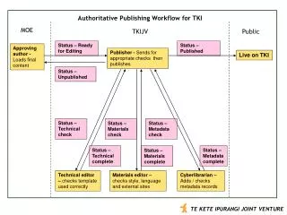
DISDI Support for DoD Real Property Inventory (RPI) • Goal: Formal registry of accurate real property data, including site locations (depicted in a standard, geospatial data format) • Site Registry - Authoritative, non-spatial repository of all DoD “sites” • Mapping Site locations (legal boundaries) is a key component of the RPI • Based on land descriptions from acquisition deeds, lease agreements, Status Of Forces Agreements, etc. • Entered via digitized Tract Maps or Coordinate Geometry (COGO) using legal (parcel) land descriptions • Two phases of pilot prototyping; 75+ installations or sites • Relevance to DoD Installations • New boundary layer (CIP or MDS) • Changes to the SDSFIE SDSFIE = DoD Spatial Data Standards for Facilities, Infrastructure, and Environment
Results of Phase I, RPI Mapping Pilot • Goals Accomplished: • Established new geo-data model for capturing RPI sites and land parcels DoD-wide • Validated geospatial data collection process and synchronization with Real Property Unique Identifier (RPUIR) registry • Established per-unit data collection costs • Process • Mapped parcels using land descriptions from legal deeds • Compiled sites in accordance with new DoD real property inventory data schema • 18 installations in National Capital Region (NCR) and US Army Corps of Engineers Seattle District area • Data delivered May 06, analysis ongoing
Phase II, RPI Parcel Mapping Pilot • 57 Installations/Sites will be mapped to support Joint Basing and Installations potentially impacted by the Energy Policy Act, 2005 • Centrally funded • Leverage lessons learned in RPI Mapping Phase I • Will be fully compliant with site and asset registry business rules and coordinated with OSD/Service real property staff • Source data for Phase II from asset registry contractor • Digitized Tract Maps, Summary Maps, Deeds, Acquisition Records • Installations to be mapped to parcel level (i.e. land asset) • RPUIDs will be assigned to parcels; Services will then aggregate parcels into sites thru government review process
Enabling “Location” In The Enterprise • DoD systems using onesource for identifying DoD location • Authoritative: Legal Interest • Efficient: Web Services • Accurate: Real-time update Minimizes human error Independent Verification and Validation
Geospatial Key Elements for the Enterprise Business Enterprise Architecture 5.0 Geo-enabled Location Universal Core (When, Where, What) Implementing Authoritative Location Spatial Data Standards for Facilities, Infrastructure, & Environment
Final Thoughts Real Property Data Spirals – Cost and Quality
Questions? Hal Tinsley, Colonel, USAF Executive Manager Defense Installation Spatial Data Infrastructure (DISDI) Office of the Deputy Undersecretary of Defense for Installations & Environment, Business Enterprise Integration Directorate ODUSD(I&E) BEI E-mail: hal.tinsley@osd.mil Ms. Lora Muchmore Director Business Enterprise Integration Office of the Deputy Undersecretary of Defense for Installations & Environment ODUSD(I&E) BEI E-mail: lora.muchmore@osd.mil