Download
1 / 21
210 likes | 705 Vues
Validation activities in Australia. Beth Ebert, Tom Keenan, Peter May, Alan Seed Bureau of Meteorology Research Centre Melbourne, Australia. Two-pronged validation approach. Site-based validation Well instrumented (polarimetric + Doppler radars, gauges, profiler, etc.) site at Darwin

E N D
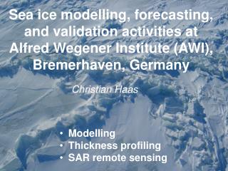
Validation activities in Australia Beth Ebert, Tom Keenan, Peter May, Alan Seed Bureau of Meteorology Research Centre Melbourne, Australia
Two-pronged validation approach • Site-based validation • Well instrumented (polarimetric + Doppler radars, gauges, profiler, etc.) site at Darwin • High space and time resolution providing diagnostic information • Ongoing and case study validation of satellite (TRMM) data • Results most useful for improving algorithms • National-scale validation over Australia • Operational daily rain gauge analysis • Large domain includes tropics and mid-latitudes • Ongoing verification of grid-scale satellite rain estimates on daily, monthly, seasonal, annual basis • Gauge-calibrated radar estimates from national network • Results most useful for identifying difficult regimes, informing users
Darwin Climate Monitoring Station • Undertake climatological monitoring and research relevant to tropical convection in the monsoon environment of Darwin, Australia Emphasis on rainfall, vertical structure of hydrometeors, rainfall estimation • Undertake detailed process studies relevant to defining the four dimensional structure, dynamics and microphysical properties of tropical convection Morphology and process studies
ARM Tropical Western Pacific ARCS-3 Site at Darwin Cloud Properties Millimeter-Wavelength Cloud Radar (MMCR) Micropulse Lidar (MPL) Microwave Radiometer (MWR) Total Sky Imager (TSI) Vaisala Ceilometer (VCEIL) Surface Meteorology Surface Meteorological Instruments for TWP (SMET) Atmospheric Profiling Atmospheric Emitted Radiance Interferometer (AERI) Balloon-Borne Sounding System (SONDE) Microwave Radiometer (MWR) Aerosols Cimel Sunphotometer (CSPHOT) Longwave Spectral Radiation Atmospheric Emitted Radiance Interferometer (AERI) Shortwave Spectral Radiation Cimel Sunphotometer (CSPHOT) Multifilter Rotating Shadowband Radiometer (MFRSR) Shortwave and Longwave Broadband Radiation Ground Radiometers on Stand for Upwelling Radiation (GNDRAD) Sky Radiometers on Stand for Downwelling Radiation (SKYRAD)
TRMM validation at Darwin using CPOL radar • reflectivity • horizontal rainfall structure
Height Median normal Bias (%) CPOL-TRMM TRMM validation at Darwin using CPOL radar • rain profiles • rain rates • microphysical classification
Microphysical studies Profiler reflectivity (920-MHz) CPOL reflectivity (over the profiler site) CPOL differential reflectivity
Microphysical studies Darwin Brandes et al., Florida TEFLUN-B (2004 JTECH)– Bringi et al., Brazil LBA (2002 JTECH) -
The Tropical Warm Pool International Cloud Experiment, Darwin, Nov. 2005 –Feb. 2006 + Soundings in Indonesia +MTSat, A-Train Describe and understand monsoon cloud structure and evolution and their impact on the environment http://www.bom.gov.au/bmrc/wefor/research/twpice.htm 大阪大学大学院工学研究科 Graduate School of Engineering, Osaka University
CP2 deployment near Brisbane Long term joint BMRC/NCAR program involving operation of the CP2 dual polarimetric, dual-frequency (S and X Band) radar. Emphasis on nowcasting severe weather and hydrological studies. 220 real-time stations providing continuous rain-fall observations (at 1 mm resolution) from about 190 sites and water level data for about 140 sites. Subtropical high rainfall regime with significant orographic enhancement (800-900 mm on the southwestern plains to over 1600 mm on the highest peaks)
Australian operational radar-raingauge network: Rainfall server Serves data that is: Quality controlled: attenuation blockage AP Gauge corrected Error statistics Coming soon: Radar-gauge blended analyses Applications: QPE, validation, hydrology
Main web page – Australia IPWG validation against Australian daily rain gauge analyses http://www.bom.gov.au/bmrc/SatRainVal/sat_val_aus.html
Pilot Evaluation of High Resolution Precipitation Products (PEHRPP) • Goals of PEHRPP: • Characterize errors in various high resolution precipitation products (HRPP) on many spatial and temporal scales, over varying surfaces and climatic regimes • Enable developers of HRPP to improve their products and potential users to understand the relevant characteristics of the products • Define data requirements and computing resources needed for retrospective processing of HRPP • Bring together scientists with different rainfall concerns: • Developers and producers of high resolution precipitation products (HRPP) • Providers of basic data (satellite observations, surface radar, rain gauge reference networks) • Users of high resolution precipitation fields
Relevance to GPM (GV) PEHRPP Hypotheses • HRPP errors can be characterized by comparing them to independent observations from rain gauges and radars. • Errors of and differences between HRPP are meaningful, in that they can be systematically related to precipitation characteristics and/or algorithm methodology. • Improved HRPP can be derived by combining products or methods based on the observed errors and differences. • HRPP spatial and temporal variability is realistic on scales appropriate for scientific studies (e.g., hydrology). • Numerical weather prediction forecasts of precipitation can be used to improve HRPP in some locations and times.
Activities ("suites") PHIL • Regional comparisons (coordinator: Joe Turk, NRL) • Large areas, long (continuous) time periods • Focus on daily totals over 0.25°x0.25° areas • Observations from national rain gauge and radar networks • Where possible, evaluate diurnal variability of HRPPs using three-hourly or finer resolution • High time resolution comparisons (coordinators: Kuo-Lin Hsu, UC Irvine; Phil Arkin, U. Maryland ESSIC) • CEOP (Coordinated Enhanced Observing Period) sites, TOGA and IMET buoys, Pacific atoll gauges, and other long term data sets • Focus on three-hourly totals over 0.25°x0.25° areas, or finer resolution • Wide variety of climatological and physical regimes • Ancillary observations may assist in understanding results
PHIL Activities ("suites") • Very high quality field programs (coordinator: Phil Arkin, ESSIC) • Selected field programs • NAME, KWAJEX, LBA, Florida, SCSMEX, .... • Focus on three-hourly totals over 0.25°x0.25° areas • Needs scientists who can do this work • "Big picture" comparisons (coordinator: ?) • Catch any artifacts not noticed in detailed statistics of above suites • obvious systematic changes on a latitude line, related to availability of certain data types • changes in time series, related to data availability • Validation of large-scale quantities and characteristics against bulk quantities, existing products (GPCP, CMAP, etc.), streamflow data sets, water budgets, and subjective judgment • Focus on thousands of kilometers and monthly