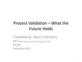
Cloud Validation: The issues
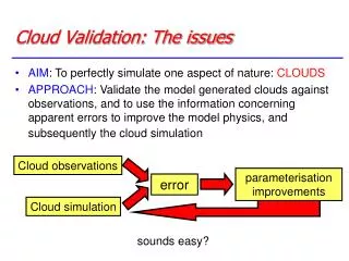
Cloud observations. parameterisation improvements. error . Cloud simulation. Cloud Validation: The issues. AIM : To perfectly simulate one aspect of nature: CLOUDS

Cloud Validation: The issues
E N D
Presentation Transcript
Cloud observations parameterisation improvements error Cloud simulation Cloud Validation: The issues • AIM: To perfectly simulate one aspect of nature: CLOUDS • APPROACH: Validate the model generated clouds against observations, and to use the information concerning apparent errors to improve the model physics, and subsequently the cloud simulation sounds easy?
Cloud Validation: The problems • How much of the ‘error’ derives from observations? Cloud observations error = e1 parameterisation improvements error Cloud simulation error = e2
turbulence radiation cloud physics dynamics convection Cloud Validation: The problems • Which Physics is responsible for the error? Cloud observations parameterisation improvements error Cloud simulation
Model climate - Broadband radiative fluxes Can compare Top of Atmosphere (TOA) radiative fluxes with satellite observations: TOA Shortwave radiation (TSR) JJA 87 TSR CY18R6-ERBE Stratocumulus regions bad - also North Africa (old cycle!)
Model climate - Cloud radiative “forcing” • Problem: Can we associate these “errors” with clouds? • Another approach is to examine “cloud radiative forcing” JJA 87 SWCRF CY18R6-ERBE Cloud Problems: strato-cu YES, North Africa NO! Note CRF sometimes defined as Fclr-F, also differences in model calculation
Model climate - “Cloud fraction” or “Total cloud cover” Can also compare other variables to derived products: CC JJA 87 TCC CY18R6-ISCCP references: ISCCP Rossow and Schiffer, Bull Am Met Soc. 91, ERBE Ramanathan et al. Science 89
Another approach is to simulate irradiances using model fields Vapour 1 Liquid cloud 1 Ice cloud 1 Radiative transfer model Vapour 2 Liquid cloud 2 Ice cloud 2 Vapour 3 Liquid cloud 3 Ice cloud 3 Height Climatology: The Problems If more complicated cloud parameters are desired (e.g. vertical structure) then retrieval can be ambiguous Channel 1 Channel 2 ….. Assumptions about vertical structures
Examples: Morcrette MWR 1991 Chevallier et al, J Clim. 2001 Simulating Satellite Channels More certainty in the diagnosis of the existence of a problem. Doesn’t necessarily help identify the origin of the problem
NWP forecast evaluation • Differences in longer simulations may not be the direct result of the cloud scheme • Interaction with radiation, dynamics etc. • E.g: poor stratocumulus regions • Using short-term NWP or analysis restricts this and allows one to concentrate on the cloud scheme Introduction of Tiedtke Scheme cloud cover bias Time
Example over Europe -8:-3 -3:-1 -1:1 1:3 3:8 • What are your conclusions concerning the cloud scheme?
Example over Europe -8:-3 -3:-1 -1:1 1:3 3:8 • Who wants to be a Meteorologist? • Which of the following is a drawback of SYNOP observations? (a) They are only available over land (b) They are only available during daytime (c) They do not provide information concerning vertical structure (d) They are made by people
Composites • We want to look at a certain kind of model system: • Stratocumulus regions • Extra tropical cyclones • An individual case may not be conclusive: Is it typical? • On the other hand general statistics may swamp this kind of system • Can use compositing technique
Composites – Extra-tropical cyclones Overlay about 1000 cyclones, defined about a location of maximum optical thickness Plot predominant cloud types by looking at anomalies from 5-day average • High Clouds too thin • Low clouds too thick High tops=Red, Mid tops=Yellow, Low tops=Blue Klein and Jakob, 1999, MWR
OLR -150 Model T95 L91 -300 -150 CERES Conclusions? -300 too high Difference too low
SW 350 Model T95 L91 100 350 CERES Conclusions? 100 albedo high Difference albedo low
TCC 80 Model T95 L91 5 80 ISCCP Conclusions? 5 TCC high Difference TCC low
TCLW LWP 80 Model T95 L91 5 80 SSMI Conclusions? 5 high Difference low
Daily Report 11th April 2005Lets see what you think? “Going more into details of the cyclone, it can be seen that the model was able to reproduce the very peculiar spiral structure in the clouds bands. However large differences can be noticed further east, in the warm sector of the frontal system attached to the cyclone, were the model largely underpredicts the typical high-cloud shield. Look for example in the two maps below where a clear deficiency of clod cover is evident in the model generated satellite images north of the Black Sea. In this case this was systematic over different forecasts.” – Quote from ECMWF daily report 11th April 2005
Same Case, water vapour channels Blue: moist Red: Dry 30 hr forecast too dry in front region Is not a FC-drift, does this mean the cloud scheme is at fault?
Future: Improved remote sensing capabilities, CLOUDSAT • CloudSat is an experimental satellite that will use radar to study clouds and precipitation from space. CloudSat will fly in orbital formation as part of the A-Train constellation of satellites (Aqua, CloudSat, CALIPSO, PARASOL, and Aura) • Launched 28th April
Cloudsat transect Zonal mean cloud cover
ADRIAN AN ICTP LECTURER Summary questions