Accident Investigation Mapping: Techniques & Applications for Gwinnett County Police
The Gwinnett County Police Department utilizes mapping in accident investigations to visualize vehicle positions, impact points, and traffic control. This mapping aids in reconstructing accidents for court presentations, allowing judges and juries to understand collision dynamics. Methods include measuring tape for 2D, Total Station, GPS for 3D, and photogrammetry techniques. This enables effective data collection in various conditions, facilitating better evidence documentation and prosecution preparation. Combined approaches optimize the accuracy and clarity of accident scenes while minimizing traffic disruption.

Accident Investigation Mapping: Techniques & Applications for Gwinnett County Police
E N D
Presentation Transcript
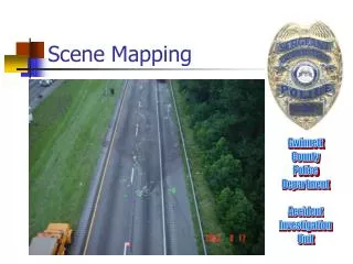
Scene Mapping Gwinnett County Police Department Accident Investigation Unit
Purpose for Mapping • Investigation / Reconstruction • Show vehicle positions, impact points, vehicle paths, and traffic control • The maps are used to obtain measurements to calculate vehicle speeds, positions in relation to each other based on time, sight distance problems • Re-creation of the collision
Purpose for Mapping • Court / Prosecution • Show vehicle positions, impact points, vehicle paths, and traffic control to the judge and jury • By changing the scale, the size of the map can be enlarged to become an important visual exhibit • It’s furnished to the defense and they can see the case is well prepared for court.
Several Ways to Create • Measuring Tape (Two Dimensional) • Coordinate Offset Method • Triangulation • Total Station (works on a type of triangulation) (Three Dimensional) • Real Time Kinetics (Global Positioning System) (Three Dimensional) • Photogametry (Three Dimensional)
Total Station • Components • Head • Data Collector • Tri-pod • Survey Rod with prism (adjustable height from .25ft to 25ft
Total Station • Components • Head
Total Station • Components • Data Collector
Total Station • Components • Tri-pod
Total Station • Components • Survey Rod with prism
Application • Widely in use • Good for every type of scene • Accesses points that are hidden behind objects • Can be used at night and in moderately foul weather conditions • Setup is about 5 minutes • Can be used while emergency crews are on scene
Manpower Requirements • One operator and one person for each prism. At least one prism is necessary. • There are systems that can be operated by one person. • Once the data is collected, it must be uploaded onto a computer to process
Different Types of Usage • May be used during the on-scene investigation • May be used after the scene is cleared by having the evidence marked • May be used again to add points not previously collected. • The data may be merged onto an aerial view of the scene. Combining Total Station and Photogametry
Typical Application • If used during the on-scene investigation, the investigator would place the prism at each point of reference and a “shot” would be taken. This would be repeated for each point of reference, the vehicles, roadway evidence, and traffic control. The dimensions of the roadway may also have be referenced.
Typical Application • The base would be placed and marked so it could be used again if necessary. • Using the system while the on-scene investigation is being made extends the time on-scene. Whether this is best for the situation depends on the roadway and traffic conditions.
Typical Application • If the evidence is marked, the scene can be “shot” on a better date and time for the traffic conditions. All the obstructions would be gone and the traffic can be controlled with better planning and appropriate manpower.
Aerial Photogametry • If the investigator has access to aerial photogametry he need only “shoot” a few reference points and the collision evidence. The reference points are used to match the data with the aerial and produce the roadway by tracing the aerial.
Conclusion • The best method of producing a scale diagram of a collision scene is a combination of the two systems. The Total Station is the best method for the on-scene evidence and works well in all situations and almost all types of weather. It’s generally not limited by terrain characteristics. The investigator needs to only be trained on one system.
Conclusion • Rather than survey the roadway dimensions, the computer operator uses the aerial photogametry and combines the data with the aerial view. The result is a merging of the two systems. • By marking the evidence with traffic paint or nails and returning at a better date and time to collect the reference information, the traffic disruption is minimized.