Download
1 / 27
280 likes | 470 Vues
GG S 2020. Global Geodetic Observing System (GGOS): Status and Future Markus Rothacher, Ruth Neilan, Hans-Peter Plag GeoForschungsZentrum Potsdam (GFZ) Jet Propulsion Laboratory (JPL) University of Nevada, Reno (UNR) AOGS 5 th Annual Meeting 2008 June 16-20, 2008 Busan, Korea.

E N D
GG S 2020 Global Geodetic Observing System (GGOS): Status and Future Markus Rothacher, Ruth Neilan, Hans-Peter Plag GeoForschungsZentrum Potsdam (GFZ) Jet Propulsion Laboratory (JPL) University of Nevada, Reno (UNR) AOGS 5th Annual Meeting 2008 June 16-20, 2008 Busan, Korea
Contents • Motivation • Monitoring and Modeling the Earth System • Structure of GGOS • GGOS Instrumentation / Infrastructure • GGOS Data Flow and Portal • Processing, Analysis, Combination • Modeling and Interpretation • Conclusions
GGOS: Monitoring and Modelling the Earth‘s System Reference frames: highest accuracy and long-term stability Global Monitoring Information about Earth System Geometry Station Position/Motion, Sea Level Change, Deformation Space Techniques VLBI SLR/LLR GNSS DORIS Altimetry InSAR Gravity/Magnet. Missions Terrestrial Techniques Levelling Gravimetry Tide Gauges Earth System Sun/Moon (Planets) Atmosphere Ocean Hydrosphere Cryosphere Crust Mantle Core C OM B I N A T I O NS I N T E R A C T I O N S Earth Rotation Precession/Nutation, Polar Motion, UT1, LOD Gravity Geocenter Gravity Field, Temporal Variations Innovative Technologies Interpretation
GGOS Chronology • July 2003: Decision of the International Association of Geodesy (IAG) to establish a Global Geodetic Observing System(GGOS) • April 2004: IAG/GGOS becomes participating organization of GEO (Group on Earth Observation) for the realization of GEOSS (Global Earth Observing System of Systems) • May 2006: GGOS becomes official member of IGOS-P (Integrated Global Observation Strategy Partnership) • July 2007: GGOS becomes an official component of the IAG, the observing system of the IAG • GGOS2020 reference document is almost complete, is in the review process (~ 200 pages)
IAG Services: Backbone of GGOS Geometry IERS: International Earth Rotation and Reference Systems Service IGS: International GNSS Service IVS: International VLBI Service ILRS: International Laser Ranging Service IDS: International DORIS Service IGFS: International Gravity Field Service BGI: Bureau Gravimetrique International IGeS: International Geoid Service ICET: International Center for Earth Tides ICGEM: International Center for Global Earth Models IDEMS: International Digital Elevation Models Service PSMSL: Permanent Service for Mean Sea Level IAS: International Altimetry Service (in preparation) BIPM: Bureau International des Poids et Mesures IBS: IAG Bibliographic Service Gravimetry Ocean Std
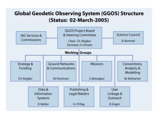
Global Networks of Observing Stations Data Analysis Centers GGOS Portal Access to all information, data, products Combination Centers Earth Observation Satellites / Planetary Missions Modeling Centers Structure of the Future GGOS Bureau for Networks and Communication Bureau for Conventions and Standards Regional and Global Data and Product Centers Archiving and Dissemination Coordination Office Mission-specific Data and Product Centers Archiving and Dissemination Users, Science & Society Bureau for Satellite and Space Missions Real data; information Meta data; information
GGOS Instrumentation: 5 Levels of Objects 5: Level 4: Moon,Planets Planets Moon
Level 1: Ground-Based Component GPS VLBI Sup.Grav. Abs.Grav. SLR/LLR Tide Gauges DORIS
Future Core Ground-Based Infrastructure Core Network (~ 40 Stations): • 2-3 VLBI telescopes for continuous observations • SLR/LLR telescope for tracking of all major satellites • At least 3 GNSS antennas and receivers (controlled equipment changes) • DORIS beacon of the most recent generation • Ultra-stable oscillator for time and frequency keeping and transfer • Terrestrial survey instruments for permanent/automated local tie monitoring • Superconducting and absolute gravimeter (gravity missions, geocenter) • Meteorological sensors (pressure, temperature, humidity) • Seismometer for combination with deformation from space geodesy and GNSS seismology • Additional sensors: water vapor radiometer, tilt-meters, gyroscopes, ground water sensors, … General Characteristics: highly automated, 24-hour/365 days, latest technologies
Ground-Based Infrastructure: Innovation • VLBI: • High slew rates (> 5 deg/s) • 1-3 small telescopes at a site • Continuous frequency range (2-18 GHz) VLBI Twin Telescope (Wettzell) • SLR: • kHz laser technology • 2 frequency systems • Higher quantum efficiency Galileo Experimental Sensor Station (GESS) kHz Laser: Lageos Spin (Graz) • GNSS: • GPS, Glonass, Galileo, Compass, … • Sampling > 10 Hz • Real-time • 3 antennas/receivers • DORIS: • 3rd generation DORIS • systems DORIS Beacon (Thule)
Level 2: Satellite Mission Component Gravity Field … GRACE Follow-on ? GRACE CHAMP GOCE Earth Surface Ocean Altimetry … … TanDEM-X TerraSAR-X JASON-2 JASON-1 Topex/Pos. Atmosphere … Magnetic Field … SWARM CHAMP CHAMP COSMIC MetOp Ice Altimetry … and new mission concepts … IceSat-2 IceSat-1 Cryosat-2
New Mission Concepts: Constellations and Formations Formation flying, swarms Satellite Constellations
New Mission Concepts: GNSS Reflectometry Future satellite constellation as a component of a Multi-Hazard Early Warning System ?
New Mission Concepts: Co-location Micro-Satellite(s) RO Antenna POD Antenna Star Sensors SLR Retro-Reflector VLBI Sender Micro- Satellite 3 GPS Receiver Board (Redundancy)
Level 3, 4, 5: GNSS + Extraterrestrial GNSS and SLR Satellites: • More than 100 GNSS satellites in 2020: GPS (24/32) , GLONASS (24/19), GALILEO (30/1), QZSS (3/0), COMPASS (30/4), … • Cheap LAGEOS-type satellites with laser retro-reflectors and with GNSS receivers forming a network in space with internally 1 mm accuracy (distances up to 14’000 km) Geodetic Planetary Missions: • Bepi Colombo, Mars missions, lunar exploration (GRAIL, LEO), … Stars (observed with CCD cameras or in future with GAIA) Quasars
GGOS Data Flow and Portal Network Synergies: • Common data communication and infrastructure for all techniques (archiving, …) • Real-time data transfer • New communication technologies for remote areas
Processing, Analysis, Combination Processing and Analysis: • Fully automated processing in near real-time or even in real-time (early warning systems, GNSS seismology, atmosphere sounding, …) • Full reprocessing capabilities for all data available, long consistent time series for long-term trends • Combination of all data types on the observation level • Combination with LEO data (co-location, gravity, geocenter, atmosphere, …) • Combination with satellite altimetry data (and with InSAR ?) • Combination with terrestrial data (e.g. gravity field, …) • Combination of different analysis centers (redundancy, reliability, accuracy, …) Improvements in modeling, parameterization, conventions Supercomputers, visualization
Combination: Tsunami Early Warning System GNSS receivers
Combination of GNSS / Seismology Sumatra Earthquake of September 12, 2007 Height [m] East [m] North [m] • Earth`s motion during the earthquake combination with seismometers • Deformation due to the earthquake (magnitude determination, rupture process)
Tsunami Buoy: Sea Level Height RMS: ~ 2-3 cm Tsunami: ~ 50 cm Filtered GPS Heights Ocean Bottom Pressure Ocean Tidal Model (GOTT)
GEOMETRY GPS, Altimetry, INSAR Remote Sensing Leveling Sea Level REFERENCE SYSTEMS VLBI, SLR, LLR, GPS, DORIS EARTH ROTATION VLBI, SLR, LLR, GPS, DORIS Classical: Astronomy New: Ringlasers,Gyros GRAVITY FIELD Orbit Analysis Satellite Gradiometry Ship-& Airborne Gravimetry Absolute Gravimetry Gravity Field Determination Combination of Geometry and Gravity (IERS/IGFS) IERS Ellipsoidal heights IGFS Physical heights, geoid
Earth System Modelling Tides of the solid Earth Global vegetation Lunisolar Gravitational acceleration Oceanic tides Ocean circulation Global ground water Density variations in the atmosphere Snow Ocean loading Atmospheric tides Deformation of the Earth Postglacial land uplift Angular torques Atmospheric loading … Angular momentum variation of the oceans Tectonic plate motion Angular momentum variation of the atmosphere Volcanism Pole tides Earthquakes Orientation of the Earth Precession,Nutation Polar motion Length of day Gravity Field of the Earth Effects from Earth interior
Terrestrial networks Altimetry missions Gravimetry missions Envisat Jason-1 Tide gauge GPS GRACE ICESat CryoSat II Example: Sea-Level Change & Ice-Mass Balances Data processing Geodynamic modeling Ocean modeling Glacial-isostatic adjustment Sea-level change (mm/a) Geoid change (mm/a)
Conclusions • Geodesy can contribute significantly to the monitoring and understanding of the Earth system • Integration of a multitude of different and innovative sensors on the ground and in space into a GGOS • Complete and consistent data processing chains ranging from the acquisition to the processing of vast amounts of observational data • Combination and assimilation of the geodetic/geophyiscal parameters into complex numerical models of the Earth system • This will finally allow the understanding and prediction of the processes in the Earth system for the benefit of human society.