3. River Profiles and Processes
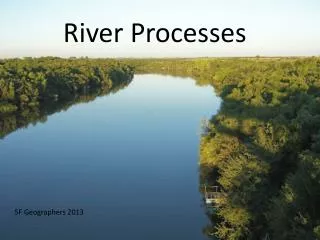
3. River Profiles and Processes. WALT To understand the 3 main courses of a river and their characteristics. Understand the main processes which happen in each stage. GENERAL CHARACTERISTICS. copy A river LONG PROFILE is a sideways look at a river valley from source to mouth.

3. River Profiles and Processes
E N D
Presentation Transcript
3. River Profiles and Processes WALT To understand the 3 main courses of a river and their characteristics. Understand the main processes which happen in each stage.
GENERAL CHARACTERISTICS copy • A river LONG PROFILE is a sideways look at a river valley from source to mouth. • It can also be called a LONG SECTION. • In an ideal river, it looks like this;-
The key to understanding how a river creates its landforms is to look at the energy needed to move the material around it. Copy • Large sized material needs high energy. • Large amounts of material needs high energy. • Tiny particles need only low amounts of energy. • Small amounts of material need little energy.
Which course has V – shaped valleys/ waterfalls/ meanders/ ox-bow lakes/ floodplains Which course has the steepest slope? Which course has the most erosion? Which course has the fastest flow? Upper Course Middle Course Lower Course Steep Slope Moderate Slope Gentle Slope Fast Flow Moderate Flow Slow Flow Erosion Transportation Deposition transportation deposition transportation V-shaped Valley Small Meander Large Meander Waterfall Small Floodplain Large Floodplain Gorge Ox-Bow Lake
Methods of Transportation • Traction: The force of water rolls and drags the larger particles long the bed of the river. • Saltation: particles bounce along the river bed. • Suspension: Finest particles (clay and silt) are carried in suspension, being swirled along by the water. • Solution: The river transports the products of chemical weathering from the hillsides and river bed.
4. River features WALT • To understand what features are found in each stage of a river • And be able to describe their formation.
Formation of a water fall (Upper course) 3. Why does the rock layer collapse? 1. Describe simply the rock-type layout of a typical waterfall. 4. What two-word landform is created by these processes? 2. Describe where and how the plunge pool is created. 5. Name and locate two examples of this feature.
ANSWERS 1.A layer of hard rock lies over softer rock. 3. The rock layer collapses as a result of the weight of the hard rock and gravity. 2.The plunge pool is created by water eroding vertically and laterally below the hard rock. 4.This creates a river gorge. 5.Thornton Force on the River Twiss, Ingleton. High Force on the River Tees.(examples only! )
Note this is a river gorge !
Can you fit these terms together with an annotated diagram? • Paragraph 1 • Upper course • River – hard rock to soft rock • Rocks different hardness erode different rates • Soft erodes quickly hard slowly • Soft downstream hard rock upstream • Explain erosion for marks • Differential erosion • Paragraph 2 • Soft rock erodes - steep section - waterfall • Base – plunge pool develops • Water swirls rocks in pool – soft erodes back further • Hard rock undercut – overhangs – collapses • Process repeats moving upstream • Paragraph 3 • Stage retreat • Narrow – steep sided valley - gorge
4 The eroded material that falls into the river is then transported downstream by the river and is deposited on its bed or on a river beach. 3 As the rock & soil from the river bank breaks up, it is transported to the river by to gravity and the wash effect of rain on the soil. 1 As the river flows it erodes downwards initially (vertical erosion), due to the great energy it has. This happens mainly because of the process of corrasion (explain in detail for in exam!) 2 The river therefore forms a deep and steep sided channel. Over time freeze thaw (again explain) weathering acts upon the riverbank. This loosens the rock and soil.
Middle course: Meanders • These are found initially in the middle stage, although they get well developed in the lower stage too. SINUOSITY WAVELENGTH POINTS OF INFLEXION
The first stages in the formation of meanders is believed to be the development of ‘riffles and pools’. These are zones of alternating deposition and erosion that cause the channel of the river to alter course, thus creating the meander.
Remember that meanders are a developing feature, changing with time and moving both across the flood plain and down-stream! Remind yourself how they do this- what are the PROCESSES?
The photograph here and the diagram on the next slide shows the processes going on below the water. Notice how the inner bank is being built up into a point bar deposit /river beach/ slip-off slope, and the outer bank is being eroded into a river cliff.
Pool River Beach Riffle River Cliff Now sequence an answer explaining this process water ~ river ~ flows ~ pool to riffles ~ pool ~ deep slow ~ riffle ~ shallow fast ~ causes ~ movement ~ water ~ side ~ side ~ development ~ meander
Inner Bend Outer Bend Slow Flow – Low Energy Fast Slow – High Energy Small Rocks Large Rocks Deposition - Sediment Erosion - Corrasion Shallower Channel Deeper Channel Builds Up Bank Undercuts Bank River Beach River Cliff
A B Formation of an ox bow lake The finale of the process is for an ox-bow lake to form.
The meanders and ox-bow lakes of the Mississippi River from the air.
The movement of the meanders create the wide floodplain and bluffs of the mature lower stage of the river.
Lower Stage • The gradient is lower • Energy levels are low • Much deposition • High sinuosity • Floodplain is wide
Levees • Levees are either natural or man-made raised banks.
Braiding • Use the textbook to help you answer these questions 1.Why are there sometimes greater than usual amounts of load in the channel? 2. What causes this load to be deposited? 3. Explain why these mounds of material are unstable?
1. Increased discharge in the river will bring down more (and larger) load from upstream. 2. If the discharge drops quickly, reducing the volume in the channel, the material will be dropped in the bed. Sometimes debris remains long enough to be colonised with vegetation which stabilises it more! 3. The material is poorly consolidated and is likely to be re-eroded with further increased discharge.
Deltas Answer these DELTA questions;- 1.Why does a delta not form if there are tides or currents? 2. Why are the beds/ sets graded by size? 3. Why do distributaries form? flow
1. Currents would wash away the deposits before they could gather. 2. As the material reaches the still water, the river flow almost stops. The heavier material drops and rolls down the slope offshore, and the medium particles fall on top of them. The lightest particles are carried further out to sea and deposited, to be covered much later by more heavy deposits. 3. Distributaries form as the water has trouble flowing over the deposited material.
Floodplain Flood = Plain = Floodplain = When a river bursts its banks. Flat area of land. The flat area of land either side of a river, which often floods. Now draw a diagram showing what a floodplain looks like and how it develops
Explaining Floodplain Development flood water – contact land area – friction – slower flow – deposition; largest stones – first –embankment – parallel – river – levee; water spreads – loses more energy – medium stones;further friction – smallest stones – valley sides; repetition of flooding – layers – sediment – build up – flatter; flat land – valley side – bluff line; sediment – build up – river channel – water – higher – land – enclosed by levees – prone to flood; flat – by river – flood; heavy rain – snow melt - discharge – river – bank bursts; energy – river – rocks;
These are flat areas of land either side of a river, which are prone to flooding (). During periods of heavy rain and or snow melt () river discharge will increase to a point whereby it bursts its banks (). The river has a lot of energy at this point and so carries many rocks () and sediment. When the flood water leaves the river channel it comes in contact with a greater land surface () and so friction between the water and land increases (), which reduces the speed of the river causing deposition (). With this initial slowing of the water the largest stones are deposited forming a small (natural) embankment () parallel with the river called a levee (). As the flood water continues to spread to the valley sides it loses even more energy depositing medium sized stones () and eventually with as it slows to a stop the smallest deposits are dropped near the valley side (). Every time there is a flood the same process happens, meaning layer upon layer of sediment builds up making the land flatter (). The point where this flat area meets the steeper valley side is caused the bluff line (). The likelihood of the river flooding is increased if a lot of sediment has been deposited in the river channel () over a period of time. This means that the river can be at a higher level than the land (), being enclosed by the levee’s, and so will be more prone to flooding ().