AMPS
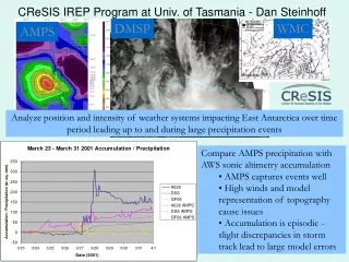
DMSP. WMC. AMPS. CReSIS IREP Program at Univ. of Tasmania - Dan Steinhoff. Analyze position and intensity of weather systems impacting East Antarctica over time period leading up to and during large precipitation events. Compare AMPS precipitation with AWS sonic altimetry accumulation


AMPS
E N D
Presentation Transcript
DMSP WMC AMPS CReSIS IREP Program at Univ. of Tasmania - Dan Steinhoff Analyze position and intensity of weather systems impacting East Antarctica over time period leading up to and during large precipitation events • Compare AMPS precipitation with AWS sonic altimetry accumulation • AMPS captures events well • High winds and model representation of topography cause issues • Accumulation is episodic - slight discrepancies in storm track lead to large model errors
Annual Variation in Passive-Microwave-Derived Melt duration These plots show 14 years of melt- duration-days and their variation with elevation for Greenland glaciers. Although many of these glaciers have accelerated, there are no strong trends in the data.
May 2006 GISMO Flight, 150 MHz, InSAR Swath Measurements of Topography Beneath the Greenland Ice Sheet Basal topography measured along a 25 km flight line and across a 3 km swath over the western Greenland Ice Sheet in May 2006. Thickness was measured using an airborne 150 MHz Synthetic Aperture Radar. The data were processed to simultaneously image the left and right sides of the aircraft. Thickness was subtracted from ICEsat surface elevation data to compute basal topography. left right
GIIPSY • Use the international constellation of remote sensing satellites to acquire ‘snapshots’ of the Arctic and Antarctic. • Use these snapshots as gauges for comparing past and future environmental changes. • In the spirit of the IGY, secure these data sets as our legacy to the next generations of polar scientists. • Global Interagency IPY Polar Snapshot Year: • Participating International Agencies: NSF, NASA, NOAA, ESA, DLR, EUMETSAT, CSA, CMA, ROSHYDROMET, WMO, WCRP-CLiC • Accomplishments: • - Contributor to IGOS-Cryosphere Report • Coordinated development of Science Requirements • Interagency SAR workshop organization: objective is • a distributed data acquisition plan • Papers submitted to ‘EARTHZINE’ and ‘Space • Research Today’