Download
1 / 44
450 likes | 848 Vues
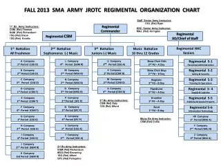
Remote Sensing Technology and Ground-Based Observations for Evaluating a Proposed Airport Site in Conway, Arkansas. Russell P. DeFusco, PhD, USAF (ret) BASH Incorporated Ronald L. Merritt, USAF (ret) DeTect Incorporated. INTRODUCTION.

E N D
Remote Sensing Technology and Ground-Based Observations for Evaluating a Proposed Airport Site in Conway, Arkansas Russell P. DeFusco, PhD, USAF (ret) BASH Incorporated Ronald L. Merritt, USAF (ret) DeTect Incorporated
INTRODUCTION • New Airport Site Sought to Replace Existing Conway Municipal Airport • Search began in early 90’s • City of Conway conducted initial surveys • Huitt – Zollars and GRW Willis Inc Airport Design and Architectural Engineers narrowed potential sites • Lollie Bottoms site preferred and selected
INTRODUCTION • Bird Aircraft Strike Hazard Potential Considered • USDA, USDWS, State Natural Resources Department, local experts consulted • Regional FAA office accepted preliminary recommendations but did not elevate to FAA Headquarters until 2004 • Mr. Ed Cleary surveyed site January 2004 • Significant concerns evident and approval of site withheld pending further study
INTRODUCTION • City Council Requested Follow-up Study to Verify or Refute FAA Findings • BASH Inc visited site beginning in Spring 2004 • FAA concerns upheld, but more extensive study required
Findings: Actual site of airport benign as previously determined.
Surrounding area flooded rice, corn, soybeans, and private duck hunting club.
Comprehensive Study • City Council requested comprehensive study to address FAA concerns • FAA requirement to demonstrated wildlife hazards at or below background levels • No established protocol however • Regional FAA office funded study through Huitt- Zollars • BASH Inc, DeTect Inc, University of Arkansas collaborators on study
STUDY PROTOCOL AND FINDINGS: • Study using 4 data sources: • BAM (historical data) • NEXRAD (archive and current) • Merlin (X-band surveyor) • Visual Observations
January BAM – Day (Jan 1-14 & 15-28) 2 3 1 4 10 5 9 6 8 7
January BAM – Night (Jan 1-14 & 15-28) 2 3 1 4 10 5 9 6 8 7
March BAM – Day (Feb 26 - Mar 11) 2 3 1 4 10 5 9 6 8 7
March BAM – Dawn/Dusk (Feb 26 – Mar 11) 2 3 1 4 10 5 9 6 8 7
March BAM – Night (Feb 26 – Mar 11) 2 3 1 4 10 5 9 6 8 7
March BAM – Day (Mar 16-Apr 8) 2 3 1 4 10 5 9 6 8 7
STUDY PROTOCOL AND FINDINGS:BAM Analysis ANOVA Table Multiple Range Tests Method: 95.0 percent LSD
NEXRAD Data Analysis • All sample sites are located 20.9 miles from North Little Rock NEXRAD • Special processing of 3 Years of Archived NEXRAD Data provide the basis for comparative site analyses • Data are 1km in resolution • Data updates are approximately every six minutes • Proposed airport site is compared to 9 other sites in the region as well as LRAFB and KLIT • Bird Density Estimates can be made from reflectivity values
NEXRAD Data • Every Six minutes – 12 sites – over 85,000 observations per site – per year! • Archived data from 2002, 2003, 2004 • Data collected 2005 and 2006 • Data processed to eliminate weather returns • dBZ values converted to “z values” • Raw “z” Values used for comparison: no adjustment for RCS or other density functions • No wind correction for wind-blown targets (insects, small birds): no reliable vertical wind profile data for ten of the sites
NEXRAD Data (2002 – 2005) Summary Statistics
NEXRAD Data (2002-2005) ANOVA Table Multiple Range Tests Method: 95.0 percent LSD
STUDY PROTOCOL AND FINDINGS:NEXRAD Monthly Trends (2002-2005)
NEXRAD Annual Trends (2002-2005) December 14, 2005 Experts: Ark. Duck Numbers Down 50 Percent By CARYN ROUSSEAUASSOCIATED PRESS BRINKLEY, Ark. (AP) - Drought conditions during the summer left Arkansas wetlands dry this winter, forcing a 50 percent decrease in the number of ducks statewide, waterfowl experts said Wednesday. "It really concentrates the ducks in areas where there is water," said Andrew James, waterfowl program coordinator with the Arkansas Game and Fish Commission. "So for those who have water it's great, but if you don't have water it's not so great."
NEXRAD Annual Trends (2002-2005) 67% Total Biological Activity in 2005 is 67% of recorded activity in 2003
Merlin X-10 Surveyor Data 24 degree beam angle
Merlin X-10 Surveyor Data Targets by Altitude Cumulative Frequency
Visual Observations University of Central Arkansas Dr. Vicki McDonald • Point –centered, 30 minutes • Road Survey - Modified BBS • All Purpose Observations
Visual Observation Data Appendix G. UCA Bird Study Summary BIRD SURVEY CONWAY, ARKANSAS REGION BRIEF RESULTS PREPARED FOR RON MERRIT, DETECT INC. Updated 08 Jun 2006 M. Victoria McDonald
Summary • Historical data (BAM) did not suggest proposed airport site was any worse than other locations • NEXRAD data did not indicate that proposed location supported increased biological activity • Merlin X-10 Surveyor data did not show increased activity during migratory periods • Visual observations did not identify the proposed site as a “hot spot” in Faulkner County
Conclusions • Proposed Airport Site is not in a migratory hot spot • Area may still attract potentially hazardous species • Impoundments (for duck hunting) must be eliminated in the area • Construction must include appropriate fencing and storm water management • Wildlife Management Plan must address agriculture • Remote Sensing data will provide input for management plan development
Questions ? Russ DeFusco (719) 264-8420 BirdmanRuss@aol.com Ron Merritt (850) 763-7200 BASHMAN@aol.com