Download
1 / 2
20 likes | 132 Vues
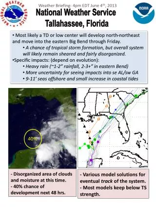
Weather Briefing- 4 pm EDT June 4 th , 2013. National Weather Service T allahassee, Florida. Most likely a TD or low center will develop north-northeast and move into the eastern Big Bend through Friday.

E N D
Weather Briefing- 4pm EDT June 4th, 2013 National Weather Service Tallahassee, Florida • Most likely a TD or low center will develop north-northeast and move into the eastern Big Bend through Friday. • A chance of tropical storm formation, but overall system will likely remain sheared and fairly disorganized. • Specific impacts: (depend on evolution): • Heavy rain (~1-2” rainfall, 2-3+” in eastern Bend) • More uncertainty for seeing impacts into se AL/sw GA • 9-11’ seas offshore and small increase in coastal tides 40% - Disorganized area of clouds and moisture at this time.- 40% chance of development next 48 hrs. - Various modelsolutions for eventual track of the system. - Most models keep below TS strength.
Weather Briefing- 4pm EDT June 4th, 2013 National Weather Service Tallahassee, Florida 30% - Seas increasing to 9-11 feet offshore Thursday and Friday. -- 5 day total rainfall thru Sunday.- Timing: late Wednesday thru Friday morning. Discussion: Pair of circulation centers apparent on afternoon satellite imagery off the Yucatan Peninsula. Current thunderstorms are displaced from the center(s) due to shear remaining over the area Tuesday afternoon. NHC expects a moderate chance of development into a tropical depression or sub-tropical low in the next 48 hrs. Models continue to converge on moving the low center into the eastern Big Bend Friday.