Digital Watershed and Beyond
300 likes | 420 Vues
The Midwest Spatial Decision Support System Partnership seeks to empower state and local decision-makers by providing access to thirteen regional decision support tools, fostering effective watershed management. This initiative, co-hosted by the US EPA Region 5, Michigan State University, and Purdue University, aims to demonstrate the effectiveness of various Decision Support and GIS Systems. Participants include water resource managers and local government representatives looking for user-friendly, science-based tools that integrate comprehensive datasets and allow for clear impact analysis. Join us as we explore the future of technology in watershed management.

Digital Watershed and Beyond
E N D
Presentation Transcript
The Midwest Spatial Decision Support System Partnership Digital Watershed and Beyond By Yi Shi, Jon F. Bartholic, and Jeremiah Asher Plus a Chorus of Dozens November 5, 2005
Topics • The Midwest Spatial Decision Support System Partnership • Digital Watershed • Where Technology Is Going • What Users Need • Future Development of Digital Watershed
Offers state and local decision-makers thirteen regional decision support tools • Includes bundled data • Means of clear impact analysis
Midwest Partnership for Watershed Management Decision Support Systems Co-hosts: US EPA Region 5, Michigan State University, and Purdue University Purpose: Demonstration of various Decision Support and GIS Systems Participants: State, Federal, and Tribal water resource managers Land Grant University Extension community, Watershed managers, and local government representatives Origin: April 2002 Midwest Web-based Spatial Workshop in Chicago
Midwest Partnership for Watershed Management Decision Support Systems Members: • Indiana Department of Environmental Management • International City/County Management Association • Michigan State University, Institute of Water Research • Purdue University - Agricultural and Biological Engineering, Forestry and Natural Resources
Midwest Partnership for Watershed Management Decision Support Systems Members cont. • State University of New York at Buffalo • University of Wisconsin Extension • U.S. EPA, Region 5 - Office of Public Affairs, Water Division and the Office of Information Services • Wisconsin Department of Natural Resources • U. S. EPA/HQ - Office of Water Smart Growth Team
Unique & Emerging Characteristics Of The Tools In demand by local officials, natural resource managers, and the general public because they deliver ease of use, bundled data, and means of clear impact analysis:
Web-based • Spatially Based and Scalable • Science-based • Accessible (in Public Domain) • Intuitive • Customizable via Features & Plug-ins • Free-standing
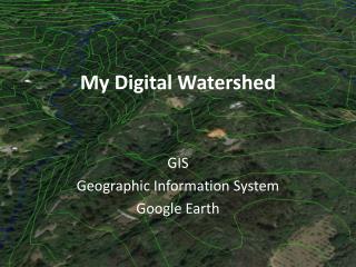
Digital Watershed A Nationwide Web Application Tool for Effective Watershed Management
Introduction • Centralized Hierarchical Information Repository • Online Watershed Computing Center • Comprehensive Datasets of EPA BASINS • Online Environmental Modeling
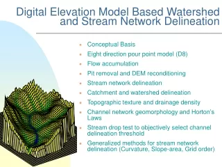
Overview • Nationwide Watershed Coverage • Multiple Forms of Access • Comprehensive Datasets • Scaling Function • Online Environmental Modeling • Erosion and Deposition Modeling Online
Where Technology Is Going • Internet-based Applications • Semantic Web through XML • Web Services • OpenGIS Consortium • GML, WMS, WFS… • Server GIS • Grid Computing
What Users Want • Tools That Can Really Solve Their Problems • Easy to Use and Easy to Understand • User Friendly Interface • Performance
Future Development • Dynamically integrate more data sources on the fly • Integrate more decision tools • Integrate remote sensing data and techniques • Take advantage of server based GIS • Develop Geoprocessing Web Services • Develop User Assistance Agent
http://www.iwr.msu.edu Thanks for Caring and Acting to Sustain the Water Resource