Download
1 / 19
190 likes | 329 Vues
This lecture covers essential concepts in weather maps and forecasting models. Due on September 22, 2006, the homework includes tasks from Chapter 4 (TYU questions: 2, 6, 9, 12, 14, 17, 18, 23, 25), focusing on the graphical representation of state variables through meteograms. Topics include surface station models, dew point analysis, and various weather prediction models, such as finite difference and spectral models. For real-time weather data and analysis, refer to links provided for various weather map resources.

E N D
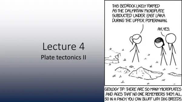
Lecture 4 Weather Maps and Models Chapters 3 and 4
Homework • Due Friday, September 22, 2006 (add to previous homework) • Ch 4 TYU 2,6,9,12,14,17,18,23,25 TYPSS #2
Meteograms • Display state variables graphically over a period of time. • AOS rooftop site: http://rig.ssec.wisc.edu/
Surface Maps Station Plots Dew point analysis MSLP analysis(mean sea level pressure) Temperature analysis
Upper Air Station Plot Upper air charts http://www.aos.wisc.edu/weatherdata
Upper Air chart(Constant pressure surface) Upper air charts http://www.aos.wisc.edu/weatherdata
Weather Models • Mathematical equations describe how: • Air accelerates or decelerates based on Newton’s Laws • Mass of air and its properties move from one position to another while conserving properties of mass and energy • Mass of water vapor is moved and transformed to rain and snow • Air is heated or cooling by condensation, radiation • These differential equations are integrated forward in time by solving them numerically on a grid
Two Basic types of Models • Finite Difference Model • Solved on a grid • Taylor series approximations to continuous equations • Spectral Model • Analysis of variables on a grid in real space is transformed to a grid in wave space grid using a Fourier transform • Equations moved forward in wave space analytically • Variables transformed back to real space
Vertical Grid • Vertical grid may be : • Height coordinate • Pressure coordinate • Sigma or terrain following coordinate
Map Projection • Various map projections are used to take into account the curved Earth surface. For instance: • Mercator projection • Polar Stereographic Grid • Lambert Conformal • Spherical Grid
Look at AOS Web Page • Real Time analysis and Prediction available on the Web: Weather Maps (Current and Forecast Maps): http://www.aos.wisc.edu/weather/index.htm (Maps drawn by UW AOS Department) http://cup.aos.wisc.edu (Tripoli’s NMS Model output) http://www.nws.noaa.gov/outlook_tab.php (National Weather Service Maps) http://weather.unisys.com/ (Unisys (Purdue) Maps….traditional leader in Internet map technology) http://www.meteo.psu.edu/%7Egadomski/ewall.html (Penn State Electronic Maps) http://www.atmos.albany.edu/weather/difax.html (NWS difax maps from SUNY Albany) http://www.rap.ucar.edu/weather/ (National Center for Atmospheric Research Weather) http://hdrweather.com/f2p2/default.htm (Colorado weather by Henz)