Download
1 / 21
280 likes | 891 Vues
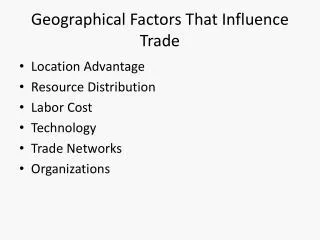
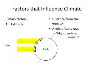
Factors that Influence Climate. a.k.a. LOWER near water. LOWER Near Water. L for Latitude O for Ocean Currents W for Winds and air masses E for Elevation R for Relief Near Water. Latitude.

E N D
Factors that Influence Climate a.k.a. LOWER near water
LOWER Near Water • L for Latitude • O for Ocean Currents • W for Winds and air masses • E for Elevation • R for Relief • Near Water
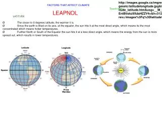
Latitude • The earth's curvature causes the sun's energy to be less concentrated at the poles than near the equator.
Latitude • Places closer to the equator are warmer than places further north or south • Warmer air can hold more moisture than colder air; therefore, areas further away from the equator are drier than areas closer to the equator.
Ocean Currents • An ocean current (like a river within the ocean water) can be warmer or cooler than the water around it. • Air above the water is affected by the temperature of the water as it passes over.
West Coast Current • The west coast has a warm ocean current called the North Pacific Current • Brings warm, moist air to the Pacific coastal areas
East Coast Currents • The cold Labrador Current flows from the north along the coast of Labrador • The warm Gulf Stream flows from the south along Nova Scotia and Newfoundland • Where they meet, fog is created. Labrador Current fog Gulf Stream
Winds and Air Masses • An air mass is a large volume of air that has the temperature and humidity of the location where it was formed. • If it formed over an ocean, it's wet. If it formed over land, it's dry. • If it formed in the north, it's cold. If it formed in the south, it's warm.
Winds and Air Masses • Winds blow these air masses from one location to another. • In Canada, most of our winds (the prevailing winds) come from the west. They are called the "Westerlies". • The Westerlies are controlled by the jet stream (a current of fast-moving air high in the atmosphere).
Winds and Air Masses • North of the jet stream it is colder than south of the it. • In the summer, the jet stream moves northward, so we get warmer weather. • In the winter, the jet stream moves further south and we get colder weather. (Textbook Fig. 12-7 is similar)
Air Masses are named for whether they formed over land or water and whether they formed in the north or the south.
Elevation • Elevation is the height the land is above sea level. • As air rises, it expands due to the decrease in air pressure. • As air expands, it cools. • Since colder air cannot hold as much moisture (water vapour) as warmer air, when the air cools, the water vapour condenses into liquid water droplets.
Elevation • Once the droplets are big enough, they will fall as rain or snow, depending on the temperature. • Summary: Areas lower in elevation tend to be warmer than areas higher in elevation. • This factor is not dependent on how the land is shaped. An area of flat land at a higher elevation is colder than an area of flat land at lower elevation.
Relief: As air is forced over mountain barriers, it cools and creates precipitation. Altitude (m) The windward side of the mountain is wetter and the leeward side is drier.
Near Water • Areas that are close to water have their climate moderated by the water so that the summer temperature are not as hot and the winter temperatures are not as cold. • Creates maritime climates near water and continental climates away from water "Lower near water"
Urban Areas • All previous factors were natural. The last factor that influences climate is man-made. • Areas in and near large cities have higher temperatures due to the fact that the pavement, cars and buildings absorb and reradiate more of the sun's energy than natural areas. • Areas downwind of cities tend to have more precipitation because the pollution particles from the city act as nuclei for water droplets.
Alert -18.1ºC • Yellowknife -5.2ºC • Point Pelee 9.1ºC Which factor accounts for these different average annual temperatures? LATITUDE
Regina • 526 mm • Toronto • 989 mm Which factor accounts for these differences in annual precipitation? NEAR WATER
Which factor accounts for the lack of vegetation on one side of the mountain? RELIEF Direction of wind The leeward side of the mountain (away from the wind) is warmer and drier than the windward side causing less vegetation to grow.
COLD LABRADOR CURRENT WARM NORTH PACIFIC CURRENT Which factors account for these differences in average annual temperature and precipitation? WINDS LATITUDE • St. John's • 5ºC, 1500 mm • Vancouver • 10ºC, 1100 mm OCEAN CURRENTS
Which factor accounts for the difference in average maximum July temperature? Kamloops 20.9ºC Calgary 16.1ºC sea level ELEVATION