Download
1 / 24
240 likes | 422 Vues
Preliminary Design Review. POES-GOES-GPS Blended TPW Products. July ??, 2008. Outline. Team Members Product Overview Project Requirements System Design Quality Assurance Documentation Project Timeline Issues To Be Resolved. Team Members. Limin Zhao, John Paquette and Stan Kidder

E N D
Preliminary Design Review POES-GOES-GPS Blended TPW Products July ??, 2008
Outline • Team Members • Product Overview • Project Requirements • System Design • Quality Assurance • Documentation • Project Timeline • Issues To Be Resolved
Team Members • Limin Zhao, John Paquette and Stan Kidder • Project Leads • Andy Jones and John Forsythe • Lead Scientists • Ivan Tcherednitchenko • Lead Developer • Peter Keehn • System Implementer • ?????? • User Team(?) • ?????? • POP Lead (?)
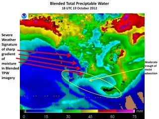
Product Overview (1) Total Precipitable Water • TPW Product • Over water: Blended AMSU & SSM/I (Kidder & Jones 2007) • Over land (primarily CONUS): • Primary: GPS PW(Ref?) • Backup: GOES PW(Ref?) 0 mm 75 mm 25 mm 50 mm
Product Overview (2) Percent of Normal TPW • Percent of Normal TPW Product • TPW divided by NVAP weekly normal TPW(Ref?) 100% 200% 0%
Product Overview (3) • Products produced every 6 hr, nominally at 00, 06, 12, and 18 UTC • Map: Mercator, 71°N to 71°S, 16 km resolution at equator • Each product is about 3.5 Mbytes in size (28 Mbytes per day) • Input data: • 5 days of AMSU and SSM/I data (? Mbytes) • most current GPS PW and GOES PW (? Mbytes) • Output data • HDF-EOS format • McIDAS format • AWIPS format
Project Requirements • SPSRB • #9902-19 POES/DMSP Blended Products: Generate operational blended TPW and RR products from POES and DMSP sensors • Others • OSIP 06-084 • NWS OB9 • User requests fromn varous WFOs • NOAA’s Hydrometeorological Testbed (HMT) • NOAA’s Scientific Data Stewardship (SDS) program Proposed products satisfy all requirements
System Design • Products will be generated at NSOF • AIX Machine will host • Input data: • AMSU and SSM/I data acquired from DDS • GPS data acquired from ??? • GOES PW data acquired from ??? • Output data (in ??? format) hosted on DDS • Output fields converted to AWIPS format and distributed by NOAAPORT (???) • (I’m sure I’m leaving things out)
Quality Assurance • By CIRA/StAR/SAB?
Documentation • Document 1—written by ? • Document 2—written by ? • …
Project Timeline (1) • Mar 08: Development Phase Begins • Mar 08: IPT Branch Lead informed to begin product development • Mar 08: Initial Archive Requirements identified • Mar 08: Quality Monitoring Concept Defined • Mar 08: Static test data file provided to NWS/AWIPS (OB9.x) • May 08: Long-term Maintenance Concept Defined • Jun 08: Preliminary Design Review • Jun 08: Development processing system defined • Sep 08: Critical Design Review • Oct 08: Code is prepared for implementation • Oct 08: Final Archive requirements identified • Oct 08: Operational and backup processing defined
Project Timeline (2) • July 08: Pre-operational Phase Begins • July 08: Pre-operational product output evaluated & tested • July 08: Final/Streaming product delivered to NWS/AWIPS • Nov 08: Operational and backup processing capabilities in place • Nov 08: Final IT Security Concept Defined • Jan 09: Code transitions to operations; all documentation is complete • Jan 08: Operational and backup capabilities reach ops status • Jan 09: Brief SPSRB capability is ready to operational • Feb 09: Operational Phase Begins • Feb 09: SPSRB declares product operational • SPSRB Secretaries/manager update the SPSRB product metrics web pages • OSD updates Satellite Products database Back to Index
Issues To Be Resolved • Porting DPEAS to AIX
Outline • Project Overview (Limin and Stan) • Project Management Overview and Planning (Limin) • AWIPS Requirements (John P) • DPEAS (Andy) • Operational System Design and Development (Limin and Andy) • Processing System Infrastructure (Ivan and Limin) • Products and Validation Plans (Stan and John F ) • QC Monitoring (Ivan and Limin) • Operational Integration and Data Dissemination (Ivan and Peter) • Summary (Limin)
Integrated Product Team • Limin Zhao, John Paquette and Stan Kidder • Project Leads • Andy Jones and John Forsythe • Lead Scientists • Ivan Tcherednitchenko • Lead Developer • Peter Keehn • System Implementer
Background • Terminology • Presentations • Requirements • Goals
Terminology • Blended TPW – • Blended TPW Normal – • DPEAS – • GRID - • AWIPS – • McIDAS -
Presentations • PDR • July 8, 2007 • CDR • Sept 2008
Requirements Documentation • NWS requests • SBSRB requirements document
NWS Requirements • Document Title: POES-GOES Blended Hydrometeorological Products • Product specifications / needs: Atmospheric temperature and moisture profiles from IASI, AMSU-A and MHS. • Data Latency: 0.5 ~ 3.0 hrs. • Refresh: per 6 hours (possibly 3 hourly). • Timeliness (e.g., how soon after observation is product needed?): 0.5 ~ 3.0 hrs
Project Goals • Provide users the blended TPW from AMSU, SSMI and GPS. • Provide updated blended products by merging data from more sensors, such as , AMSR-E, TRMM, … • Provide blended RR products
POES/GOES Blended Hydro Products • Blended TPW • Blended TPW Normal • Blended RR