Download
1 / 28
290 likes | 451 Vues
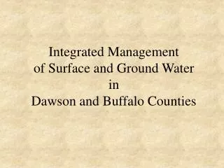
Integrated Management Of Hydrologically Connected Surface Water and Groundwater. NPNRD Boundaries. 4 Hydogeologic Regions. Streams and Canals. Registered Wells 2003. Source:Jennifer Schellpeper DNR. North Platte River Valley. The link between groundwater and surface water.

E N D
Integrated ManagementOf Hydrologically Connected Surface Waterand Groundwater
Registered Wells 2003 Source:Jennifer Schellpeper DNR
The link between groundwaterand surface water • Most groundwater originates as recharge from irrigation canals • BoR: About 3.8 cubic feet per second per mile or about 2,460,000 gallons of water per day per mile (7.5 acre-feet) seeps out of Interstate Canal • As a result, groundwater levels have risen 120 to 140 feet from estimated predevelopment to current era (typical pre-drought levels). • Groundwater in alluvial aquifer is less than 30 years old; overall mean age is 8.8 years
Conceptual Hydrogeologic ModelOf North Platte River Valley Schematic hydrologic model near canal
Groundwater Level Changes In the Northern Table Lands
Effects of the Drought • The following three slides compare hydrographs (water level changes) for three wells from a normal water year, 1997, with the extremely dry summer of 2002. The 1997 hydrographs (indicated by the red lines) show how well levels begin rising after the irrigation canals are filled, and continue to rise throughout the summer and into the fall. But the 2002 hydrographs (purple lines) show that well levels began rising later and began declining sooner. This demonstrates that a shortage of surface irrigation water will affect the availability of groundwater. • To compound the effects, irrigators responded to the shortage of surface water by drilling more wells, placing additional stress on the groundwater resources.
Examples of ConflictsBetween Groundwater Users and Surface Water Appropriators
Integrated Managementof Hydrologically Connected Surface Water and Groundwater Authorized by Statute, Section 46-656.28 • Part of LB108, passed into law in 1996 • NRDs may establish management areas to address conflicts or potential conflicts between groundwater users and surface water appropriators. NPNRD Board initiates process and DNR responds. • In September 2002, the NRD board votes to send a letter to DNR expressing interest in joint action plan. DNR responds with preliminary determination that there is reason to believe that the use of hydrologically connected surface water and groundwater is or might contribute to conflicts, disputes or difficulties. NPNRD Board conducts hearing on November 1, 2002 • Following hearing, board approved 3-year suspension on new well permits, effective immediately.
Integrated ManagementWhy Did the North Platte NRD Initiate the Process? The North Platte Basin’s “plumbing” is unique. • Most groundwater originates as recharge from surface-water irrigation canals. Groundwater levels have risen approximately 130 feet since development; average “age” of groundwater is 8.8 years. Groundwater travels through the aquifer and tributaries to eventually return to the river. The drought of 2002-03 magnified the SW/GW connection. • Canals carried less water -- enough to last only part of the irrigation season. As a result, NRD received many reports of problems with wells.
Integrated ManagmentWhy did the North Platte NRD Initiate the Process? Conflicts between surface water users and groundwater users. • Declines in stream flows • Changes in the timing of return flows from irrigation to streams and rivers • Reports of wells going dry • Lack of return flow affecting surface water irrigators • Wetlands and sub-irrigated meadows drying up, especially in the sand hills and northern table land. • Water quality issues (stable discharge to streams is preferable for diluting contaminants) • Surface water-groundwater inequity complaints. Surface water irrigators are under regulation, while nearby groundwater irrigators can continue pumping.
Temporary Suspension on PermitsDetails Wells that are affected by the temporary suspension: • New wells with a pumping capacity of more than 50 gpm. Wells that are not affected: • Wells with a pumping capacity of 50 gpm or less. • Replacement wells. • Test holes • Temporary dewatering wells. Variances can be considered for: • Monitoring wells. • Wells to withdraw or treat contaminated water. • Wells to alleviate emergencies involving water for human consumption.
Down the Road:Department of Natural Resources conducting study • Nature of SW/GW conflict • Cause of SW/GW conflict • Extent of area affected • Expected completion: Fall 2003
Down the Road:Developing a Joint Management Plan • Work with stakeholders to identify goals. • Translate goals into management objectives. • Select and implement management tools to attain objectives. • NRD regulates groundwater; DNR regulates surface water.