Title
Title. Yield Gap Studies through C omparative P erformance A nalysis ( CPA ). Dr. C.A.J.M. de Bie ITC, Enschede, The Netherlands Commission VII, Working Group VII/2.1 on Sustainable Agriculture Pre-Symposium Tutorial. Presented are : Current problems, mandate and methods.

Title
E N D
Presentation Transcript
Title Yield Gap Studiesthrough Comparative Performance Analysis(CPA) Dr. C.A.J.M. de Bie ITC, Enschede, The Netherlands Commission VII, Working Group VII/2.1 on Sustainable Agriculture Pre-Symposium Tutorial • Presented are : • Current problems, mandate and methods. • Concepts to study sustainability aspects of agricultural land use systems. • A case study to demonstrate CPA.
1.Poverty Trap Increasing population High population Shorter or no fallow periods Low yields Persistent soil degradation Expansion onto unsuitable soils 1 Current problems, mandate and methods Good yields The downward spiral to the poverty trap Nutrient removals Soil degradation Falling Yields The Poverty Trap
Trends Land Use Trends · Increase in cultivated area Sustainability Study Goals · Intensification (crops/ha; stocking density) · Heavier natural vegetation exploitation Problems · Competition for same tract of land · Declining yields Declining yields · Land and natural vegetation degradation Land and natural vegetation degradation Needs · Assessment which land uses are relevant for which tracts of land and present needs · Assessment by land use type, which management minimizes environmental impacts while maximizing productivity Assessment by land use type, which management minimizes environmental impacts while maximizing productivity
Mandate Our Mandate to study “Sustainable Agriculture”. Fact: Detailed and reliable quantitative information on present land use is scarceand often of low quality. We need good land use data : We need practical concepts and approaches : • to address questions as put on record by the UNCED conference in Rio (1992; Agenda 21, Chapter 10), e.g.: • to identify options to solve future food requirements. • to understand and combat environmental degradation. • to gather, manage, classify and map land use information. • to study various aspects of present day land use systems.
LE Current “Land Evaluation” study method. • Based on generic crop-specific factor rating tables. • Typically ignores management effects. • Does not truly evaluate land use. • Evaluates “crops”. Lack of method ?
Yield Gap Yield limiting / reducing factors not controlled at the research Yield Gap-0 station Non-transferable technology Yield Gap-1 Environment and management constraints Simulated Market access potential Experi- ‘research · Prices Gap-2A mental station’ Diminishing returns maximum yield Gap-2 Technical Lack of inputs ‘research ‘on-farm’ farmers’ risk station’ Gap-2B ceiling aversion stra- yield Economic (= Potential tegies ’on-farm’ farm yield) ceiling Actual This level may differ ‘on-farm’ considerably from yield plot to plot. Current “Yield Gap” study entries. Considers levels ‘fixed’; it omits variability between sites/areas.
Conv.-Simul. Current “Management-Yield” study approaches. • Based on technology transfer. • Focused on only few management aspects at a time. • Expensive. • Based on knowledge. • Management typically excluded. • Limited operational use. Lack of method ?
2.The Concepts Context Socio - Economical Conditions Goals Land User(s) Bio - Physical Conditions Land Use System Land Land Use Soil / Terrain Land Use Climate / Weather Purpose(s) Vegetation (Crops / Flora) Inputs / Outputs Wildlife (Fauna) / Implements Operation Benefits Sequence Infrastructure Other Land Use Systems Livestock Systems 2 The Concepts The “Land Use System” (LUS) with ‘study entries’. Decision making / planning Requirements & Suitability Productivity Impact on land ( + or - ) Impact on/from the environment Interaction with secondary production systems
Cover/Use What is Land Cover and what is Land Use ? • Failure to distinguish between the two has created much confusion. • Land cover is a part of land, whereas land use isnot. • Some examples: • The cover"forest" is identified by its physical components such as vegetation structure, height, density, and extent. The useof “forest” is dictated by its purpose(s) like: rubber production, conservation, recreation, timber production, or shifting cultivation. • The land cover“grassland”, distinguished by the presence or dominance of grass (herbaceous vegetation) may be usedfor hay production, grazing, recreation, etc. • Land coveris defined as: "The vegetation (natural or planted) or man made constructions (buildings, etc.), which occur on the earth surface … …”. • Land useis defined as: “A series of operations on land, carried out by humans, with the intention to obtain products and/or benefits through using land resources”. Land cover can be determined by direct observation. Obtaining land use information requires communication with the land user.
Repetition Impact on land ( + or - ) Repetition … • Landproblems: • limits growth • reduces yields Land useaims tomodify land to reduce land problems Land Use System Land Land Use Purpose(s) - climate - weather Aimed at [Species/Services - landform - - terrain Products/Benefits] - soil combinations. - flora (incl.crops) Operation - fauna Sequence Inputs Outputs Details on - results of past Operations Implements land use (incl. used infrastructure)
Oper.Seq. Operation Sequences 1969 1975 1979 1988 1989 Grazing Fallowing Rainfed Cropping 1989 1988 J F M A M J J A S O N D Operations NPK Applic. Ploughing Weeding Seeding Harvesting Fallow Observations Pest Attack Germination Rill Erosion Trampling Hail Storm The “Operation Sequence” impacts on ‘sustainability’ aspects. Land Use System Illustrating land use operations Land Use … many aim to control growth limiting, and yield reducing land aspects. and land obser-vations … many relate to growth limiting, and yield reducing land aspects. Land
Sust.Studies Problems Problems Problems Problems CPA studies this gap. Plot-to-plot variability Feasible Problems Yield Problems Management What do sustainability studies do ? they address: growthlimiting yieldreducing land modifyingaspects of LUSs. CPA relates differences in land and management aspects to differences in system performances. CPA uses survey data from many plots.
Holding A Plot defines spatially a unique Land Use Systems.
F.System A Farm is the unit that controls several Land Use Systems.
Crop Calendar Land use is mapped using crop calendar data and RS-images. Date of image
Survey Data Relevant land use data to survey. Photo / Image characteristics Interview data • holding/holder information (profile) • site aspects (tenancy arrangement, cadastral no., distance to holding, infrastructures present) • land use system (plot) aspects for the period considered: • a-priori land use class • crops grown / services provided (% of area, numbers, etc.) • land use purposes • operations (crop calendar / cropping pattern): • operation name; species involved; % of plot involved; period / periodicity / duration and task times; main power source • labor and material inputs and implements used • products / benefits obtained • observations by land user: • soil related (workability, infiltration rate, fertility status, etc.) • weather related (hail storm, dry period, etc.) • crop related (pests, diseases, lodging, wilting, etc.) • 1D-features (tone, color), as related to: • crop calendars, cropping patterns and other land use operations • Infrastructure • 2D-features, such as: • field sizes, shapes and patterns • internal patterns (textures, grids, mottles) • line features • 3D-features (on APs): • vertical structure • no. of layers Observation by surveyor • plot size, coordinates, slope, position, etc. • crops (residues) and infrastructure present in / around the plot • land cover data (crop condition, growing stage, weed incidence, biomass, height) • ground cover status (bare soil, mulch, crop residues) • specific observations (soil characteristics, tillage condition, erosion status, hydrological aspects, pests / diseases incidence, evidence of grazing)
Math Function Survey data Observations on land (crop) by the surveyor / land user Interview data Yield Data on the operation sequence Impact on land e.g. erosion, bulk density, or salinity data Function to analyze the surveyed Land Use data. Performance= f ( land, land use )
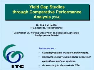
3.CPA Example 6000 20 Reported Yld. = 0.915 x Crop cutting Yld. (R-Sq=73%) Correlation Coeff. = 85% 5000 15 4000 regression Yield (kg/ha) line Count 10 3000 2000 1:1 line 5 Reported 1000 0 0 0 1000 2000 3000 4000 5000 6000 0 1000 2000 3000 4000 5000 6000 kg / ha Crop Cutting Yield (kg/ha) 3 A CPA example. The impact of land use and land aspects on yields of sticky rice in Phrao, Thailand. Yields of 63 paddies varied from almost ‘0’ to almost 5500 kg/ha. Yield reported by farmers (21x) were vali- dated through crop-cuttings. The yields The CPA study did explain 83% of the shown yield variability.
Multi-Temp. The multi-temporal NDVI image is used to map different crop calendars (next slide…). Multi-Temporal TM image analysis…… ……Climate represented in a P-ETo diagram.
Phrao Map 2150000 7500 5000 2500 2140000 7500 5000 2500 5000 7500 520000 2500 5000 Paddies with low cropping intensity (one crop per annum) Paddies with high cropping intensity (two or three crops per annum) Villages In the Phrao floodplain water flows freely across bunded paddies. The facts If water is available, a second or third crop can be grown after rice. Distance from weirs strongly affects the cropping intensity, drought risk, and yields. Areas with a high cropping intensity could be mapped by using the 3 TM-images.
Oper.Seq. Avg.date Ploughing 9 July Puddling 13 July Levelling (harrowing) 16 July Trans - planting 8 Aug. Chemical weeding (39x) 13 Aug. 5 Sep. NPK - Application(42x) 7 Dec. Harvesting (Day no.) 160 230 300 370 (9 Jun) (18 Aug) (27 Oct) (5 Jan) By site, data on the operation sequence were recorded. Shown are the starting dates by operation.
H2O-Shortage Period of Water Shortage Count Average yields(kg/ha) Establish-ment Vegeta-tive Heading + Flowering Yield formation Y N N N 9 2893 Y N Y N 2 2109 Y Y N N 3 2069 N Y N N 12 2605 N Y Y N 5 2019 N N N N N N N N 19 19 3932 3932 N N Y N 13 2101 Impact of Water Shortage on Yield.
Pest/Diseases Infection rates (%) Pests / Disease Freq. Correlationwith yields Inter-Correlations Use in M. Regr. ? Rice Blast 63 -64 None Yes Leaf blight 10 -34 37% with RB Exclude Brown Leaf Spot 18 -17 None Yes False smut 41 -12 20% with RB Exclude Stem Borers 17 -12 None Try Black bugs 7 -8 None Try Sheath rot 12 0 - No effect Foot rot 2 0 - No effect Impact of Selected Pests and Diseases on Yield.
Lodging Period of lodging Freq. Average riceyields (kg/ha) Average lodging-% During Heading/Flowering 15 2300 34 (7.5-60.0) None 31 3187 0 During Yield Formation 9 1988 21 (12.5-27.5) During Ripening 8 3585 20 (12.5-27.5) Impact of Lodging on Yield (severity and impact).
Planting Date 160 6000 150 5000 140 4000 Length crop growing period (days) 130 Yield (kg/ha) 3000 120 2000 110 1000 100 90 0 180 190 200 210 220 230 240 250 90 100 110 120 130 140 150 160 Planting date (day of the year) Length crop growing period (days) Delayed planting of sticky rice is associated with shorter crop-growing periods that cause in turn lower yields. The crop is photo-sensitive. Other factors cause the ‘noise’.
Model Estim. Model estimation through multiple regression.
Yield Gap Quantified break-down of the yield gap by constraint.
Bar Diagram 7000 Potential Yield 6000 weeding soil type variety 5000 lodging Yield Gap water stress Actual Yield diseases 4000 timely planting cropping system Yield (kg/ha) 3000 Average Yield 2000 1000 0 farmers fields research station • Through regression analysis: • the yield constraints were identified, • and impacts by constraint quantified … The results
Conclusion Final statements on the yield constraints. The results The yield constraints and their relative importance: • water shortage(41%) • diseases incidence (22%; rice blast / brown leaf spot) • late planting (18%) • lodging (10%) • poor soil condition (8%) Relevant land characteristics: Advise to local organizations: • Water-loss from paddies, defined by the soil infiltration rate (= site specific) • Water shortage, defined by the distance from weirs(= map unit specific) • Plant breeders must concentrate on resistance to drought, diseases, and lodging. • Extension services are best concerned with water management, timely planting, and control of diseases.