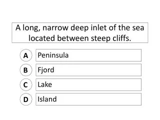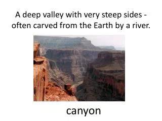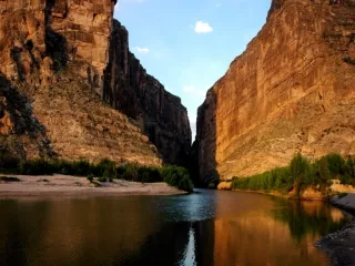
A deep narrow valley with steep sides.
490 likes | 910 Vues
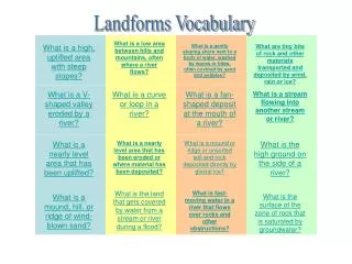
A deep narrow valley with steep sides. Canyon. __ are underground layers of rock or sand that trap water. aquifers. Dry land with little precipitation. desert. A line that measures how far north or south from the equator a place is. latitude. This river carved the Grand Canyon.

A deep narrow valley with steep sides.
E N D
Presentation Transcript
__ are underground layers of rock or sand that trap water. aquifers
A line that measures how far north or south from the equator a place is. latitude
This river carved the Grand Canyon Colorado River
Lines of ___ measure how east or west from the Prime Meridian a place is. longitude
This “colorful” desert in found in northern AZ and NM. The Painted Desert
This desert is found in the southern part of Texas into Mexico. Chihuahuan Desert
0 degrees longitude. Prime meridian
A canal or pipe that carries water to cities and farms aqueduct
A deep narrow valley with steep sides found in Arizona. Grand Canyon
A __ is a place where underground water reaches the surface. Natural spring
The large desert found in southwest Arizona. Sonoran Desert
A small flat topped hill Butte
A special type of factory that turns crude oil into refined products like gasoline or heating oil. refinery
0 degrees latitude. The Equator
___ are man made substances that are produced from petroleum. petrochemicals
90 degrees north. The North Pole
This water feature separates Texas from Mexico. The Rio Grande
The major plateau found in the southwest in part of AZ and NM. Colorado Plateau
STATE ARIZONA
CAPITAL AUSTIN
PLAIN COASTAL PLAIN
CAPITAL OKLAHOMA CITY
RIVER RIO GRANDE
RIVER COLORADO RIVER
PLAIN GREAT PLAINS
SANTA FE CAPITAL
DESERT SONORAN
RIVER RED RIVER
STATE OKLAHOMA
DESERT PAINTED DESERT
DESERT CHIHUAHUAN DESERT
CANYON GRAND CANYON
STATE TEXAS
PLAIN STAKED PLAIN
WATER GULF OF MEXICO
CAPITAL PHOENIX
STATE NEW MEXICO