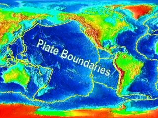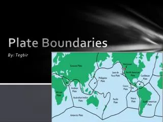
Plate Boundaries
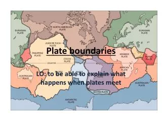
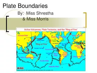
Plate Boundaries. 3 main types of boundaries. Divergent (plates diverge, or move away) Convergent (plates converge, or come together) Transform (plates slide past each other). Divergent boundary. Plates move away (or spread) from each other. New crust is created here.

Plate Boundaries
E N D
Presentation Transcript
3 main types of boundaries • Divergent (plates diverge, or move away) • Convergent (plates converge, or come together) • Transform (plates slide past each other)
Divergent boundary • Plates move away (or spread) from each other. • New crust is created here. • Magma forces plates apart. • Example: • Mid-Atlantic Ridge • Great Rift Valley in East Africa
Geologic phenomena at divergent boundaries:* = unique to divergent boundaries • Iceland* (formed right on top of Mid-Atlantic Ridge) • Volcanoes • Earthquakes • Mountains • Fault-block mountains (one side is dropping lower as crust spreads) • Mid-Ocean Ridges* • Rift Valleys* • Spreading Zones* • Crust is spread out and stretched as plates move apart.
Mid-Ocean Ridges • Undersea mountain ranges that are also a plate boundary. • Formed by magma flowing to surface, forming new crust. • Forces plates apart = seafloor spreading
Rift valleys (divergent) • A deep valley formed by the two plates moving away from each other. • Crust warps downward, spreads, eventually “breaks” (boundary comes to surface)
Convergent boundary • Plates move toward each other and collide. • Crust is destroyed here. • Subduction: Where one plate sinks underneath another and is forced into the mantle (then melted)
Geologic phenomena at convergent boundaries • Volcanoes • Earthquakes • Mountains • Folded mountains (crust crumples/folds upward) • Trenches/subduction zones* • Volcanic Island Arcs (ocean-ocean boundary)*
Types of Convergent boundaries Continent-Oceanic • Ocean plate collides with a continent. • Ocean plate sinks. • Forms a trench. • Trench: also called a subduction zone, where one plate subducts under the other.
Continent-Oceanic, continued • Examples: • Juan de Fuca plate and North American plate • Juan de Fuca plate subducts under N.A. plate; created the Cascade Mountain Range in Northern CA, OR, and WA. • Nazca plate and South American plate • Subduction of Nazca plate formed Andes Mountains on west coast of S.A.
Types of Convergent boundaries, continued Continent-Continent • Two continents colliding • Pushes the crust upward to form mountains.
Continent-Continent Example • The Himalayas and Mount Everest—formed by Indian Plate and Eurasian Plates colliding.
Types of Convergent boundaries, continued Oceanic-oceanic • Two ocean plates collide. • The older one sinks under the newer one. • Creates volcanic island arc *Not Hawaii!*
Oceanic-Oceanic examples • Mariana Islands (volcanic!): Formed by Philippine plate and Pacific plate • Tonga Trench in South Pacific (Pacific plate subducting under Australian plate) • Fastest moving plate: 24 cm/year!!
Transform boundary • Plates move past each other laterally. • Example: • San Andreas Fault (formed by North American and Pacific plates)
Geologic phenomena at transform boundaries • Earthquakes • Mountains (folded mountains) • Warping of crust • Displacement of Mid-Ocean Ridges
Evidence supporting Plate Tectonics • Seafloor topography (the physical conformation of the ocean floor) • Mid-ocean ridges (undersea mountains and boundaries; proof that there are plates and they can move) • Trenches (proof that there are plates and that they are moving) • Island chains (Hawaii!!): can help track movement of a plate over a hotspot • Magnetic reversals
Island Chains/Hot Spots • Island chains: line of volcanic islands and seamounts caused by a hot spot. • Example: Hawaiian Islands
Hot spot: long-lasting, extra hot region in mantle; causes volcanism • Can track movement of a plate over a hot spot • Volcanoes form and move away from hot spot as plate moves. • New volcanoes then take place of old ones.
Magnetic Reversals • Earth’s magnetic field changes polarity (reverses) every 500,000 years or so. • Geographic North becomes Magnetic South. • These magnetic reversals are preserved in rock formed at mid-ocean ridges • We can see how ocean floor has grown over time and moved away from mid-ocean ridge.
What happens: • At mid-ocean ridges, when molten rock cools and solidifies, iron-containing minerals align with current magnetic field. • Records orientation of magnetic field at the time it solidified. • Creates “bands” of normal magnetic polarity, then reverse, then normal, then reverse, etc. • Allows us to “track” the growth of the ocean floors • Shows their movement over time. “