Download
1 / 21
220 likes | 416 Vues
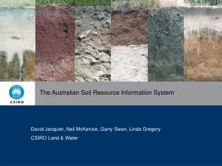
The Australian Soil Resource Information System. David Jacquier, Neil McKenzie, Garry Swan, Linda Gregory CSIRO Land & Water. The elements of ASRIS. ASRIS is an online geographic information system and it:

E N D
The Australian Soil Resource Information System David Jacquier, Neil McKenzie, Garry Swan, Linda Gregory CSIRO Land & Water
The elements of ASRIS • ASRIS is an online geographic information system and it: • Provides access to the best available soil and land resource information across Australia • Combines the best of qualitative mapping with new quantitative information • Integrates soil and land information from many sources • Opens many new possibilities for monitoring and forecasting the condition of Australia’s soils and landscapes • Focuses on providing estimates of functional soil attributes (e.g. soil pH, electrical conductivity, available water capacity) and uses soil classification as a means of communication
The ASRIS data model • The key elements: • A spatial hierarchy of land units with seven levels of generalization • The upper three levels provide general descriptions of soils and landscapes across the continent. • Lower levels provide detailed information for regions where mapping is complete • A consistent set of soil attributes (e.g. soil depth, permeability, water storage) • Soil attributes are presented for idealised soil profiles that have five contiguous soil horizons • A soil profile database of fully characterised sites that are representative of significant areas and environments • Estimates of uncertainty for soil attributes to encourage formal analysis of the uncertainty of predictions generated
Thank You Contact CSIRO Phone 1300 363 400 +61 3 9545 2176 Email enquiries@csiro.au Web www.csiro.au CSIRO Land and Water David Jacquier Project Officer with the Australian Collaborative Land Evaluation Program 02 6246 5916 david.jacquier@csiro.au www.asris.csiro.au