Download
1 / 7
70 likes | 217 Vues
Mrs. Ray’s Georgia History Class. Chapter 1 Terms and Places. Absolute location-Identifies a precise position on the earth’s surface (latitude and longitude). Relative location-Describes where something is located as compared to other places.

E N D
Mrs. Ray’s Georgia History Class Chapter 1 Terms and Places
Absolute location-Identifies a precise position on the earth’s surface (latitude and longitude). Relative location-Describes where something is located as compared to other places. Geography-The science of studying the earth as the home of humans. Hemisphere-one ½ of a sphere.
Axis-The imaginary straight line around which an object rotates. • Equator-The imaginary line that goes around the globe exactly ½ way between the North and South Pole. • Parallels-The imaginary lines that run E. & W. side by side with the equator. (latitude) • Latitude-A measure of distance N. or S. of the equator expressed in degrees, minutes, and seconds. (across)
Meridians-A line that runs N. & S. from one pole to another/longitude measures. Prime meridian-The imaginary line that runs from N. Pole to S. Pole (0 degrees). Longitude-A measure of distance E or W of Prime Meridian expressed in degrees, minutes, seconds (up and down). Region-An area on earth that is identified by certain unifying characteristics. Precipitation-Rain, hail, sleet, or snow. Wetland-A low-lying area where water lies close to the surface creating sloughs, sounds, etc.
Fall Line-The point at which hilly or mountainous lands meet the Coastal Plain.****** Climate-Type of weather a region experiences over a period of time. Weather-The day to day conditions & changes in the atmosphere. Vertical climate-Climate that is influenced by elevation. The higher the elevation, the cooler it gets. Drought-A lack of precipitation over a period of time that results in water shortages. Wind current-Continuous movement or flow of air. Trade winds-Winds from the equator to around 30 degrees N. latitude that flow from the NE. Prevailing westerlies-Winds from 30 degrees E to 60 degrees E north and south of the equator that blow W to E. Ocean currents-Rivers of ocean water. Hurricane-A tropical storm spawned when waters of 80 degrees F or more transform the heat energy of tropical waters into strong winds and heavy waves. Tornado-A storm of swirling cyclonic winds that move from SW to NE & spin counterclockwise. Barrier Island-An island that lies off the coast and protects the beaches by blocking most of the wind, sand, & water that could erode the mainland.
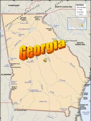
El nino-Warmer than normal Pacific Ocean surface temperatures. La nina-Colder than normal Pacific Ocean surface temperatures. Global warming-The raising of the average temperatures on the earth due to an excess of carbon dioxide in the atmosphere. Appalachian Plateau region-A region of GA that lies in the far NW corner. Ridge and Valley region-A region of GA that lies between Blue Ridge Mtns. and Appalachian Mtns. Blue Ridge region-A region of GA in the NE corner of the state. Piedmont Plateau region-A region of GA that begins at the foothills of N. GA and extends to the Coastal Plain. Coastal Plain region-A region of GA that runs from the coast to the Piedmont Plateau. Okefenokee Swamp-The largest swamp in N. America; has black water; ½ million acres. Tallulah Gorge-On US 441 between Habersham & Rabun counties; 1200 ft. deep. Radium Springs-Near Albany in Lee County; healing powers; 1927 resort; sapphire blue waters.
38. Warm Springs-Near Pine Mt. in Meriwether County ; FDR treated his polio here. Stone Mountain-Confederate carvings located on the mountain; Jefferson Davis, Robert E. Lee, Stone wall Jackson. Providence Canyon- Near Lumpkin; called the “Little Grand Canyon.” Amicalola Falls-Near Dawsonville; waterfalls. Write this down on your terms page- Georgia is located: Northern hemisphere Western hemisphere North American continent United States of America (country) South (region) SE part of the U. S. On the eastern seaboard On the Atlantic Ocean States that border GA: AL, FL, SC, TN, NC