Download
1 / 29
290 likes | 316 Vues
This overview discusses technological advancements in flood forecasting, including new data sets for flood forecasting, satellite-derived precipitation estimates, and ensemble weather forecasts. It also explores future improvements such as remotely-sensed river discharge and catchment-scale water balance using the GRACE satellite system.

E N D
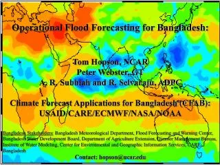
Technological Improvements in Flood Forecasting Thomas Hopson National Center for Atmospheric Research (NCAR)
Overview: Technological improvements in flood forecasting New data sets for flood forecasting - satellite-derived precipitation estimates - ensemble weather forecasts II. Coupling new data sets to hydrological models - case study: Bangladesh CFAB project III. Future improvements: remotely-sensed river discharge - Dartmouth Flood Observatory IV. Future improvements: catchment-scale water balance - GRACE satellite system
Satellite-derived Rainfall Estimates 1) Satellite-derived estimates: NASA TRMM (GPCP) 0.25º X 0.25º spatial resolution; 3hr temporal resolution 6hr reporting delay geostationary infrared “cold cloud top” estimates calibrated from SSM/I and TMI microwave instruments 2) Satellite-derived estimates: NOAA CPC “CMORPH” 0.25º X 0.25º spatial resolution; 3hr temporal resolution 18hr reporting delay precipitation rain rates derived from microwave instruments (SSM/I, TMI, AMSU-B), but “cloud tracking” done using infrared satellites • Both centers now producing rapid 8km X 8km spatial resolution; 30min temporal resolution; 3hr latency (roughly) • Other similar products: NRL, CSU, PERSIANN 3) Rain gauge estimates: NOAA CPC and WMO GTS 0.5º X 0.5º spatial resolution; 24h temporal resolution 24hr reporting delay
Spatial Comparison of Precipitation Products Monsoon season (Aug 1, 2004) Indian subcontinent TRMM
Weather Forecasts for Hydrologic ApplicationsECMWF example • Seasonal -- ECMWF System 3 - based on: 1) long predictability of ocean circulation, 2) variability in tropical SSTs impacts global atmospheric circulation - coupled atmosphere-ocean model integrations - out to 7 month lead-times, integrated 1Xmonth - 41 member ensembles, 1.125º X 1.125º (TL159L62), 130km • Monthly forecasts -- ECMWF - “fills in the gaps” -- atmosphere retains some memory with ocean variability impacting atmospheric circulation - coupled ocean-atmospheric modeling after 10 days - 15 to 32 day lead-times, integrated 1Xweek - 51 member ensemble, 1.125º X 1.125º (TL159L62), 130km • Medium-range -- ECMWF EPS - atmospheric initial value problem, SST’s persisted - 6hr - 15 day lead-time forecasts, integrated 2Xdaily - 51 member ensembles, 0.5º X 0.5º (TL255L40), 80km Motivation for generating ensemble forecasts (weather or hydrologic): • a well-calibrated ensemble forecast provides a prognosis of its own uncertainty or level of confidence
Rule of Thumb: -- Weather forecast skill (RMS error) increases with spatial (and temporal) scale => Utility of weather forecasts in flood forecasting increases for larger catchments -- Logarithmic increase
Overview: Technological improvements in flood forecasting New data sets for flood forecasting - satellite-derived precipitation estimates - ensemble weather forecasts II. Coupling new data sets to hydrological models - case study: Bangladesh CFAB project III. Future improvements: remotely-sensed river discharge - Dartmouth Flood Observatory IV. Future improvements: catchment-scale water balance - GRACE satellite system
CFAB Project: Improve Bangladesh flood warning lead time Technical: Peter Webster (PI), GT A.R. Subbiah, ADPC Funding: USAID, CARE, ECMWF • Problems: • Limited warning of upstream river discharges • Precipitation forecasting in tropics difficult Assets: Good data inputs => ECMWF weather forecasts, satellite rainfall estimates 2. Large catchments => weather forecasting skill “integrates” over large spatial and temporal scales 3. Partnership with Bangladesh’s Flood Forecasting Warning Centre (FFWC) => daily border river readings used in data assimilation scheme
Merged FFWC-CFAB Hydraulic Model Schematic Primary forecast boundary conditions shown in gold: Ganges at Hardinge Bridge Brahmaputra at Bahadurabad Benefit: FFWC daily river discharge observations used in forecast data assimilation scheme (Auto-Regressive Integrated Moving Average model [ARIMA] approach)
Weather Forecast Ensembles Transformed into Discharge Forecasts Ensembles Precipitation Forecasts Discharge Forecasts 1 day 4 day 1 day 4 day 3 day 4 day 10 day 7 day 7 day 10 day
Transforming (Ensemble) Rainfall into (Probabilistic) River Flow Forecasts Rainfall Probability Discharge Probability Rainfall [mm] Discharge [m3/s] Above danger level probability 36% Greater than climatological seasonal risk?
2003 Model Comparisons for the Ganges (4-day lead-time) hydrologic lumped model hydrologic distributed model • Multi-Model-Ensemble Approach: • Rank models based on historic residual error using current model calibration and “observed” precipitation • Regress models’ historic discharges to minimize historic residuals with observed discharge • To avoid over-calibration, evaluate resultant residuals using Akaike Information Criteria (AIC) • If AIC minimized, use regression coefficients to generate “multi-model” forecast; otherwise use highest-ranked model => “win-win” situation! Resultant Hydrologic multi-model
Multi-Model Forecast Weighting (Regression) Coefficients - Lumped model (red) - Distributed model (blue) • Significant catchment variation • Coefficients vary with the forecast lead-time • Representative of the each basin’s hydrology • Ganges slower time-scale response • Brahmaputra “flashier” Improvements: incorporating 78 multi-model approach (M. Clark, NIWA) - blending elements from ARNO/VIC, PRMS, Sacramento, TOPmodel
Final flood forecast “calibration” or “post-processing” “bias” obs Forecast PDF Probability Probability Forecast PDF obs “spread” or “dispersion” calibration Flow rate [m3/s] Flow rate [m3/s] • Post-processing has corrected: • the “on average” bias • as well as under-representation of the 2nd moment of the empirical forecast PDF (i.e. corrected its “dispersion” or “spread”) • Our approach: • under-utilized “quantile regression” approach • probability distribution function “means what it says” • daily variation in the ensemble dispersion directly relate to changes in forecast skill
2004 Brahmaputra Ensemble Forecasts and Danger Level Probabilities 7-10 day Ensemble Forecasts 7-10 day Danger Levels 7 day 8 day 7 day 8 day 3 day 4 day 3 day 4 day 5 day 5 day 9 day 10 day 9 day 10 day
Five Pilot Sites chosen in 2006 consultation workshops based on biophysical, social criteria: Rajpur Union -- 16 sq km -- 16,000 pop. Uria Union -- 23 sq km -- 14,000 pop. Kaijuri Union -- 45 sq km -- 53,000 pop. Bhekra Union -- 11 sq km -- 9,000 pop. Gazirtek Union -- 32 sq km -- 23,000 pop.
2007 Brahmaputra Ensemble Forecasts and Danger Level Probabilities 7-10 day Ensemble Forecasts 7-10 day Danger Levels 7 day 8 day 7 day 8 day 9 day 10 day 9 day 10 day
Overview: Technological improvements in flood forecasting New data sets for flood forecasting - satellite-derived precipitation estimates - ensemble weather forecasts II. Coupling new data sets to hydrological models - case study: Bangladesh CFAB project III. Future improvements: remotely-sensed river discharge - Dartmouth Flood Observatory IV. Future improvements: catchment-scale water balance - GRACE satellite system
Satellite-based River Discharge Estimation Bob Brakenridge, Dartmouth Flood Observatory, Dartmouth College • River Watch
Application to the Ganges and Brahmaputra Rivers Brahmaputra floodwave isochrons Ganges River Watch sites • Utility of River Watch discharge estimates to flood forecasting: • Calibration of ungauged subcatchments outflow and routing • Operational improvements through data assimilation -- blending of enKF, 4DVAR, and “quantile regression”
Overview: Technological improvements in flood forecasting New data sets for flood forecasting - satellite-derived precipitation estimates - ensemble weather forecasts II. Coupling new data sets to hydrological models - case study: Bangladesh CFAB project III. Future improvements: remotely-sensed river discharge - Dartmouth Flood Observatory IV. Future improvements: catchment-scale water balance - GRACE satellite system
Gravity Recovery And Climate Experiment (GRACE) Slide from Sean Swenson, NCAR
GRACE catchment-integrated soil moisture estimates useful for: 1) Hydrologic model calibration and validation 2) Seasonal forecasting 3) Data assimilation for medium-range (1-2 week) forecasts Slide from Sean Swenson, NCAR
Conclusions • Exciting time for flood forecasting for both developed and developing countries: -- satellite-based observational sensors provide global and timely estimates of water budget components -- coupling hydrologic forecast models to (ensemble) weather forecasts greatly extends forecast time-horizon • Case study: CFAB Brahmaputra and Ganges river flow forecasts: -- 2003: went operational with ECMWF ensemble weather forecasts -- 2004: 1) forecasts fully-automated; 2) forecasted severe Brahmaputra July flooding events -- 2007: 5 pilot areas warned citizens many days in-advance during two (July-August, September) severe Brahmaputra flooding events Further Advances: • Data assimilation of new satellite-derived products: -- Dartmouth Flood Observatory river discharge estimates -- GRACE integrated catchment soil moisture -- QSCAT and TMI soil moisture estimates (Nghiem, JPL) • Expansion of multi-model approach (78 member multi-model) • Daily-updated seamless weather-to-seasonal flood forecasting: -- utilizing short-, medium-, monthly-, and seasonal ensemble forecasts
Thank You! hopson@ucar.edu