Download
1 / 19
190 likes | 299 Vues
Explore GIS architectures, ISO 191xx standards, societal motivations, and practical applications. Learn about metadata, modeling, and geographic metadata producers.

E N D
Information System Architectures Rupa Tiwari, CSci5980 Fall 2010
Outline • Course Material Classification • GIS Encyclopedia Articles • Classification Diagram • Course – Encyclopedia Mapping • Modeling with ISO 191xx Standards • Societal & Computer Science Motivation • ISO 191xx Article in Detail • References
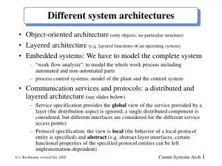
Course Material Classification Text Chapter 7, GIS Architectures Modularity & Interoperability 7.1 Hybrid and Integrated architectures 7.2 Syntactic and Semantic Heterogeneity 7.3 Distributed Systems 7.4 Distributed Databases 7.5 Location-aware computing
GIS Encyclopedia Articles • National Spatial Data Infrastructure (NSDI) • Modeling with ISO 191xx Standards (ISO) • OGC's Open Standards for Geospatial Interoperability (OWS) • Critical Evaluation of Remote Sensing Standards (RS Std) • ArcGIS: General Purpose GIS Software System (ArcGIS) • Intergraph: Real Time Operational Geospatial Applications (Intergraph) • University of Minnesota Map Server (Map Server) • Mobile P2P Databases (P2P)
Classification Diagram [Note: Cell color darkens with further classifications]
Course - Encyclopedia Mapping Text Chapter 7, GIS Architectures Modularity & Interoperability 7.1 Hybrid, Integrated and Composable architectures 7.2 Syntactic and Semantic Heterogeneity NSDI, ISO, RS Std 7.3 Distributed Systems OWS 7.4 Distributed Databases P2P 7.5 Location-aware computing ArcGIS, Intergraph, Map Server Practical Applications [Note: Topics in dark and bold font are not in our text book. Relevant encyclopedia articles depicted in cells.]
Modeling with ISO 191xx Standards • ISO 191xx standards provide a structure for application development related to geographic data and refer to existing standards in IT and communications like W3C, OMG, IETF, OASIS etc. • Collaborative effort of ISO Technical Committee 211 and Open Geospatial Consortium. • Aim is to reduce the inconsistency between de jure and de facto standards. • Metadata refers to the content, structure, semantics, lineage, quality, vintage, resolution and distribution format etc. • Conceptual models, conceptual schemas, application schemas, database models, data dictionaries, feature catalogs etc are the approaches to document the geographic information metadata . [ISO191xx suite of standards details at http://www.iso.org/iso/iso_catalogue/catalogue_tc/catalogue_tc_browse.htm?commid=54904&published=on&includesc=true]
Societal & Computer Science Motivation • Interoperability of geographic information • Geographic Information Database Design • Geographic Information Data Modeling. • Disaster Management, Traffic Management etc applications which need to integrate data from different sources like roads, drainage, satellite images, relief etc. Geographic Metadata Producers and Users of Society
ISO/TS 19103 UML is used as the conceptual modeling language. The standard also includes definitions of a number of data types which provide a common ground for the representation of attributes and values. The figure illustrates that the class EX_Bridge has an attribute structure of type Ex_BridgeStructure. EX_BridgeStructure is a codelist and enumerated are its acceptable values.
ISO 19107 The geometric and topological characteristics that are needed to describe geographic features spatially. They provide all components needed to depict the shape and the location of simple geographic features such as buildings, rivers etc. The figure represents basic geometric primitives
ISO 19108 Defines primitives, topological primitives and topological complexes for the description of the temporal characteristics. The figure shows the temporal primitives, TM_instant and TM_period.
ISO 19109 Defines a number of rules to develop and maintain consistent application schemas. An application schema is a conceptual schema or model for geographic data that is required by one or more applications. The figure illustrates an example of application schema
ISO 19110 Mechanism for the documentation of the semantics of all application schema elements. A feature catalog includes a description of itself, feature types, feature property type, feature operations, relationships and association roles etc. The figure shows the feature catalog of road-bridge example.
ISO 19111 Provides the mechanism for describing a Coordinate Reference System (CRS).
ISO 19112 Spatial referencing by Geographic Identifiers specifies a mechanism and components to describe geographic references based on geographic identifiers.
ISO/TS 19115 Sets the content and structure of geographic metadata. It covers topics like identification, constraints, quality, lineage, maintenance, spatial representation, reference system, content, portrayal, distribution and application schema.
ISO/TS 19135 Procedures to be followed in establishing, maintaining and publishing registers of unique, unambiguous and permanent identifiers, and meanings that are assigned to items of geographic information.
References • http://www.iso.org/iso/iso_catalogue/catalogue_tc/catalogue_tc_browse.htm?commid=54904&published=on&includesc=true • http://sdi08.rosa.ro/images/sdi.png • http://www.gsdidocs.org/gsdiconf/GSDI-7/papers/TU-4.pdf