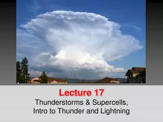
Supercells
Supercells. Base lecture and Graphics created by The COMET Program May 2002 University Corporation for Atmospheric Research. Objective.

Supercells
E N D
Presentation Transcript
Supercells Base lecture and Graphics created by The COMET Program May 2002 University Corporation for Atmospheric Research
Objective • “To be able to forecast and better recognize supercell storms in all their forms and have a better understanding of how they form and the severe weather elements that accompany these storms.”
Overview • Introduction to Supercells • Supercell Types and Features • Supercell Environments and Evolution • Supercell Processes • Operational Supercell Issues
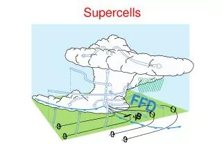
Definition • Supercell storms are those storms with long-lived cores and rotating updrafts. • Supercells tend to have • one of several distinctive radar reflectivity patterns • they contain mesocyclones • and they generally have a different storm motion than other nearby ordinary cells. • Supercells are frequent producers of large hail, strong winds, and tornadoes.
Supercell Terminology(Mesocyclone) • A mesocyclone is a rotating vortex in conjunction with the updraft in a supercell storm. • Supercells develop mesocyclones by tilting environmental and/or locally generated horizontal vorticity.
Mesocyclone Example • When viewed with Doppler velocity imagery a typical mesocyclone appears as a cyclonic circulation ~2-10 km in diameter with values of the toward-and-away velocity couplet on the order of 25 to 75 m/s.
Supercell Terminology(WER) • Because of the very strong updraft associated with supercell storms they are able to suspend a great many precipitation particles aloft. This overhang creates a weak echo region (WER) when observed on radar. • The existence of a WER is a good indicator of a potentially severe storm.
Supercell Terminology (BWER) • The still stronger updraft causes a change in the configuration of the WER. A cavity sometimes develops in the mid-level overhang, creating what is known as a “bounded weak echo region” or BWER. • An updraft of this magnitude and longevity can produce very large hailstones (>2 inches) and the “steadier state” of the supercell can result in a long hail swath at the surface.
BWER Example • Here’s a BWER in cross section • On a PPI scan a BWER looks like a reflectivity donut
Supercell Terminology(Hook Echo) • In the more intense supercells, the mid-level mesocyclone will eventually become strong enough to wrap precipitation around to the backside of the updraft, creating a characteristic pendant or hook echo.
Hook Echo Example • The low-level mesocyclone is located within the notch of the hook echo
Supercell Terminology(V-Notch) • In the stronger supercell cases, a slot of weaker radar reflectivity known as a V-notch may also appear on the downshear edge of the reflectivity field
Supercell Classifications There are four categories of supercell storms • Classic Supercells • Heavy Precipitation (HP) Supercells • Low Precipitation (LP) Supercells and • Shallow (a.k.a. Mini or Low-topped) Supercells All of these may be either Right-moving, Left-moving, or both (Splitting storms)
Classic Supercells • Wedge-shaped, generally isolated long-lived storms with rotating updrafts • Often possess a WER or BWER and/or a hook echo • Frequent producers of severe weather including large hail, strong winds, tornadoes, and heavy rain
HP Supercells • More common east of the Plains states • Produce heavier rain than classic supercells and tend to be less isolated than other supercell types • Are capable of producing extreme hail falls, tornadoes, prolonged downburst winds and flash flooding
HP Supercell Evolution • Have a “kidney bean” shape on radar • Stages 3 4, and 5
LP Supercells • Most common along the dryline of west Texas and in the High Plains • Are generally smaller in diameter than classic supercells
LP Supercells • Still capable of producing severe weather especially large hail and to a lesser extent tornadoes, although funnel clouds are common.
Shallow Supercells • Are much smaller both horizontally and vertically than the other supercell types. These mini storms may be as small as only 20,000 ft (~6 km) tall with much smaller horizontal dimensions than classic varieties being as small as 6 km in diameter!
Synoptic Patterns • Favorable conditions conducive to supercells often occur with identifiable synoptic patterns • The favorable ingredients that support supercells in these environments are lots of instability and shear
Environmental Factors Because they are so long-lived and intense it is highly desirable to be able to determine in advance if supercells are likely • Luckily the length and shape of a hodograph can be very helpful in making this determination! • Strong and deep vertical wind shear values (> =25 m/s or ~50 kts over the lowest ~6 km AGL) tend to be associated with supercell formation
Impact of CAPE • Supercells, like other severe thunderstorms, usually occur with significant instability (CAPE values 1000-2000 J/kg or more) • Very severe storms with some supercell characteristics can also form when shear values are negligible, but CAPE values are extremely large (> 5,000 J/kg). • In some highly dynamic environments supercells can form with a minimal amount of CAPE and with tremendous low-level shear*.
Cape and Shear / BRN • However, supercells most commonlyform when the environmental vertical wind shear and instability are balanced • BRN values between 10-50 are generally associated with supercell storms
Shallow Supercell Environments • Mini supercells occur when CAPE is shallow and values are small. They most typically arise in two very different environments 1) with land-falling hurricanes and 2) in wintertime high shear low buoyancy winter situations
Shallow Supercell Environments • The thing that these two environments have in common is extremelow-level shear values (sometimes 60 kts over the lowest 2-3 km AGL!)
Supercells with Bow Echoes Bow echo and supercell
Shear Creating Vorticity • When the vertical wind profile is sheared, horizontal vorticity is present in the environment. We can visualize this vorticity if we imagine the rotation that would be imparted to paddle wheels placed in the environment.
Storm Tilt • Vertical wind shear and buoyancy gradients across the cloud act to tilt the convective tower in the downshear direction. For a given amount of shear, a stronger, updraft will not tilt as much as a weaker updraft simply because its vertical momentum is stronger.
Storm Tilt (cont.) • The precipitation in a storm tilted by shear will largely fall downshear of the updraft, producing a distinctive reflectivity pattern with a tight gradient near the updraft. • Even though the precipitation is not falling back on the updraft as it does for non-sheared convection, this does not appreciably extend the life of the storm. The cold pool produced by the precipitation can still kill the storm.
Rotation Creates Low-Pressure • It is also important to understand that at this scale, wherever there is rotation, low pressure is induced regardless of the direction of the rotation.
Stretching Process • Vertical stretching (like by a strong updraft) also increases rotation