Download
1 / 10
100 likes | 209 Vues
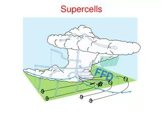
Detailed analysis of atmospheric conditions and radar images from the severe weather outbreak in Kansas on May 7th, 2002, demonstrating the formation of tornadic supercells. Meteorological data from Austin Cross, San Francisco State University Department of Geosciences.

E N D
Kansas Tornadic Supercells May 7th, 2002 Austin Cross San Francisco State University Department of Geosciences
500mb Chart for Mar. 8, 00Z • Ideal conditions set up • a low in the Great Plains • air drawn in from Gulf • perpendicular winds aloft
KOUN Sounding for 00Z Curved hodograph CAPE: 4161 J/kg CIN: -1 J/kg 6km Shear of 49 3km Helicity of 272
KTOP Sounding for 00Z Curved hodograph Large amount of CIN 6km Shear of 69 3km Helicity of 690
GOES Visible Image for 2145Z Anvil visible
GOES Visible Image for 2315Z Storm has expanded and Moved eastward
Radar Image for 2235Z Dodge City
Radar Image for 2305Z Dodge City