Download
1 / 20
200 likes | 311 Vues
This document outlines the creation of a simulated synthetic natural color product for the GOES-R satellite, presenting a solution to generate natural color images despite the lack of a green channel in GOES-R data. The method leverages MODIS data to establish reflectance relationships across various surfaces, atmospheric conditions, and seasonal variations. It discusses the generation of green reflectance using available channels and details the use of a Bidirectional Reflection Distribution Function (BRDF) for modeling land surface reflectance. Through various improvements, the project aims to enhance natural color image generation.

E N D
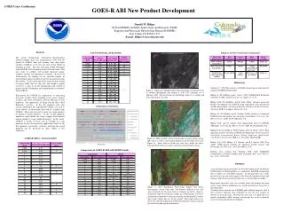
Development of a Simulated Synthetic Natural Color ABI Product for GOES-R AQPG Hai Zhang UMBC 1/12/2012 GOES-R AQPG workshop
Outline • Overview of the problem and our solution • The method used in AQPG 2011 summer demo • Further improvement of the method
The problem for GOES-R natural color image generation • We need red, green, blue reflectance to generate natural color image • MODIS has the three channels so that it is easy for us to generate natural color images from MODIS data • GOES-R does not have a green channel • Following is a list of GOES-R visible and NIR/SWIR channels and the corresponding MODIS channels
Our solution • Use MODIS data to find the relationship of reflectance in green channel to the other channels • The relationship can be different for different types of surface, atmospheric condition, and different for different seasons, sun-satellite geometry … • Land • Ocean • Cloud • Aerosol • Apply the relationship on GOES-R data to derive green reflectance from the channels available
Land surface reflectance generation • Land surface reflectance varies for different satellite-sun geometry. Such variation can be modeled by BRDF (bidirectional reflection distribution function) • MODIS land surface BRDF product • The product is derived using 16 days of MODIS data and updated every 8 days • The 6 channels corresponding to GOES-R visible/NIR/SWIR channels and the green channel • With BRDF data, we can calculate land surface reflectance in any sun-satellite geometry • For the summer 2011 demo, the satellite is assumed to be located at 75°W above equator, which is the position of GOES-East.
Surface reflectance vs. Sun-satellite geometry for GOES – an example • Satellite angles are fixed, solar angles change during a day • A selected pixel in the eastern US: Satellite is fixed Sun moves θs : Solar zenith angle, changes θv: Satellite zenith angle, fixed φs- φv :Relative azimuth angle, changes
Scatter plots between green and GOES-R bands on land surface southeastern US area (summer 2011 demo) The red channel has the best correlation with the green channel: 0.9
Natural color generation land for land surface (summer 2011 demo) MODIS RGB land surface Land surface using derived green Red=MODIS red Green= 0.69*red+0.04 Blue=MODIS blue
Ocean surface • Use a Rayleigh corrected MODIS scene to get relation on ocean surface
Algorithm flow chart for summer 2011 demo Income GOES-R TOA reflectance proxy data Rayleigh correction Land surface? Natural color image generation No Green=red×1.07+0.01 Yes Derived green Green=red×0.69+0.04 Output image
An example of natural color image animation from GOES-R proxy data (2011-7-26)
Explanation of image blurriness in the early morning and in the late afternoon noon • TOA reflectance observed from satellite contains contribution from the surface and the atmosphere • The atmosphere contains aerosols even in clear days • In the early morning and late afternoon, solar zenith angle is large and hence the light • passes through more air mass or aerosolsthan at the noon. Early morning or late afternoon Short path through atmosphere Long path through atmosphere surface AOD=0.1 AOD=0.0 Atmosphere contribution Surface contribution
Further improvement • The regression between red and green can be different • Different surface type • Different season • Different time during a day • Add blue channel • Can we improve? • Cloud and aerosol
Improvement #1: Land surface over US • Use MODIS BRDF to calculate surface reflectance at GOES-East geometry • Divide surface into 1°× 1° area • Investigate the linear regression relation between red and green for each area, season and time in a day • Build look-up-table (LUT) • Slope, intercept for each area, day in a year, time of a day • Use the LUT and input red signal to derive green
Seasonal change – correlation coefficient Mostly above 0.9 winter spring 0.0 0.5 1.0 0.0 0.5 1.0 0.0 0.5 1.0 summer fall 0.0 0.5 1.0 0.0 0.5 1.0
Improvement #2: Add reflectance in blue channel • Assume the relation to be: green=A1×red+A2×blue+B • Repeat the same procedure as for red to build LUT • LUT include two slopes (A1 and A2) and one intercept (B) for different area, season, time of the day
Comparison of the original and two improvements • Only apply the relation to surface reflectance in red less than 0.3 • The comparison is over the whole US on day 137 green=0.69*red+0.04 Usered LUT Usered and blue LUT
True color Green=0.69*red+0.04 Natural color using derived green from LUT withred and blue channel Natural color using derived green from LUT with red channel
Algorithm flow chart for improved method Income GOES-R TOA reflectance proxy data Rayleigh correction No No Land surface? Cloud with reflectance > 0.3? Green=red×1.07+0.01 Yes Yes Green=redx0.96+0.02 Derive green from LUT Derived green Natural color image generation Output image
Summary • Green reflectance can be derived from red and blue channels • The relationships are verified by analyzing MODIS RGB images and data • In summer 2011 demo, we use a fixed relationship to derive green reflectance from red • We improved the method: • Over land surface, we build LUT based on MODIS BRDF • Over ocean and clouds, we use fixed relation with red