Download
1 / 28
280 likes | 308 Vues
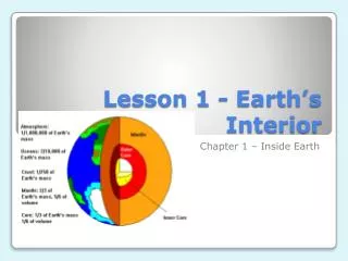
Explore the fascinating history of Earth through the work of geologists, who uncover clues about our planet's past. Discover the principles of uniformitarianism, the impact of continents on climate and ocean dynamics, and the tools used to study Earth's geological features. Dive into the mysteries of the oceans, the complex geology of continents, and the driving forces behind plate tectonics.

E N D
Uniformitarianism • Laws of nature same today as in the past • Rates of processes may change (e.g. more heat flow in Archaen, so faster plate tectonics?) • Some processes very rare (large meteor impacts), but we can estimate their frequency and try to scale up the effects
Oceans cover 70% of earth • Continental shelves are continental crust • Ophiolites, oceanic crust • Most continents covered by shallow marine rocks (shelf) • Very few deep marine rocks exposed on land • No old rocks left in the oceans • Oceans have very simple geology, continents very complex
Continents affect climate and ocean dynamics, and in the past they have been wildly different • Difference in Arctic and Antarctic Oceans—what would happen with open ocean pole? • Difference Pacific and Atlantic because of Bering Strait (deep water formation) • Difference with Isthmus of Panama (only closed <10 Ma) and equatorial circulation • In Cretaceous, circum-equatorial current
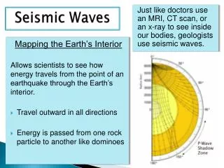
Tools • Paleomag—get past latitudes • Rock type gives hints about latitude • Isotopes can give temperature • Fossils can give salinity • Reflection seismic profiles can give view of structure and stratigraphy (TWTT, and sound velocity changes) • Earthquake focal mechanisms (“beach balls”) • Bathymetry/topography—maps tell us a lot • Gravity, geoid • Magnetic anomalies, isochrons
Magnitude 5.1 SOUTHERN CALIFORNIA 2008 December 06 04:18:42 UTC
Age Last Thermo-Tectonic Event http://quake.wr.usgs.gov/research/structure/CrustalStructure/database/age.html
Figure 8. Relative-motion vectors of plates in Antarctica-fixed framework. Predictions that subduction, due to top-down cooling, drives plates, that ridges are passive responses to that drive, and that lower mantle does not participate in plate motions are satisfied in this framework when allowance is made for back-arc spreading and plate-internal deformation. Data from geodesy-dominated model by Kreemer et al. (2003) . Image provided by L.H. Estey, University NAVSTAR Consortium; see jules.unavco.ucar.edu/Voyager/ILP_GSRM
Figure 26. Absolute velocity field major plates at anomaly 31 (67.7 Ma) in a paleomagnetic reference frame. White areas have been subducted.
Bathymetry Magnetic anomalies Age models
Figure 1. Paleoarchean heterolithic and polycyclic migmatite (tonalite, granodiorite, pegmatite, and mafic rocks), Acasta Lake, Slave craton, northwest Canada. Nearly concordant ion-microprobe U-Pb ages, by S.A. Bowring, of zircons from this outcrop scatter from 3.96 to 3.5 Ga. Only felsic gneisses are known as basement beneath Archean supracrustal rocks, including ultramafic volcanics.
Figure 3. Landsat satellite image of Mesoarchean granite-and-greenstone assemblage, central Pilbara craton, NW Australia. Domiform crustal-melt granitic batholiths (light; 3.5–2.9 Ga zircons) rose during and after deposition of 3.5–3.2 Ga ultramafic, mafic, and felsic volcanic rocks and sediments (multicolor stripes) preserved in open to tight and complex synclines. Another greenstone cycle, Neoarchean mafic and felsic volcanic rocks and iron formation, ca. 2.8–2.6 Ga (brown), overlies older units in S and in small syncline in N. Geology mapped by Geological Survey of Western Australia geologists. Area 175 km wide. Image supplied by Australian Centre for Remote Sensing, Australian Surveying and Land Information Group. Colors assigned to spectral bands: blue to visible green, green to near-IR, red to mid-IR.
Figure 4. Neoarchean conglomerate. Cobbles of leucogranite and pebbles of felsite, eroded from diapiric granite, with downdip stretching due to continuing rise of granite and sinking of greenstone syncline. Vertical surface near Wawa, Superior craton, Ontario.
Figure 2. Archean fuchsitic quartzite, Lake Winnipeg, Superior craton, Manitoba, part of thin section deposited on basement gneiss (zircons ca. 3.0 Ga) and overlain by thick pillow basalt (ca. 2.7 Ga). Mapping and dates by J.A. Percival and associates. Coin diameter: 3 cm
Figure 7. Subduction drive of plate tectonics, illustrated for a common type of continent-margin system. Hinge rolls back so slab sinks broadside, pushing sub-plate upper mantle back under shrinking ocean and forcing rapid spreading, and sucking overriding plate forward. Slab plus entrained material is plated down on uncrossable 660 km discontinuity, overridden by continent, and recycled into slowly enlarging ocean offscreen to right. Shallow part scaled to modern Sumatra and Cretaceous California; low-velocity mantle wedge deduced from high-resolution tomography in Japan; kinematic inferences from this paper. Drafted by Dietrich Roeder, Murnau Geodynamics, Inc.