Download
1 / 4
40 likes | 195 Vues
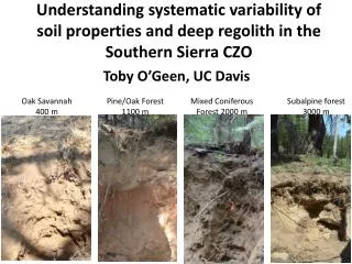
Toby O’Geen, UC Davis. Understanding systematic variability of soil properties and deep regolith in the Southern Sierra CZO. Oak Savannah 400 m. Pine/Oak Forest 1100 m. Mixed Coniferous Forest 2000 m. Subalpine forest 3000 m. Regional patterns in soil development and regolith thickness.

E N D
Toby O’Geen, UC Davis Understanding systematic variability of soil properties and deep regolith in the Southern Sierra CZO Oak Savannah 400 m Pine/Oak Forest 1100 m Mixed Coniferous Forest 2000 m Subalpine forest 3000 m
Regional patterns in soil development and regolith thickness 1100 2000 3000 Deep regolith Soil Degree of Weathering 400 1100 2000 3000 Elevation (m) Oak Savannah 400 m Pine/Oak Forest 1100 m Mixed Coniferous Forest 2000 m Subalpine forest 3000 m
Some pedologic questions: • What are the dominant factors controlling soil development across the gradient? It may not be what previous studies thought. • What is the extent of soil variability within each catena? Soil Variability at San Joaquin Experimental Range Depth
Some deep regolith questions: • What soil forming factors are most important in describing spatial patterns in regolith thickness? Do quantifiable proxies exist (i.e. terrain attributes, solar radiation models, gamma-ray imagery)? • How variable is regolith thickness within each catena? To what extent do terrain attributes describe this variability? • How do other regolith characteristics very across the CZO transect?