Enhancing Coastal Observing Systems: The Cast-Net Framework for Improved Data Connectivity
170 likes | 282 Vues
The Cast-Net project stems from the NSF EPSCoR SURA Grant, aiming to enhance connectivity among coastal observing systems. By creating a regional framework, it facilitates better communication and sharing of coastal observation capacities. Key objectives include developing tools for data collection and management, identifying common monitored parameters for regional analysis, and ensuring compatibility with national and international ocean observation standards. The initiative embraces metadata standards like FGDC and utilizes flexible systems for effective documentation tailored to the needs of various labs and researchers.

Enhancing Coastal Observing Systems: The Cast-Net Framework for Improved Data Connectivity
E N D
Presentation Transcript
An NSF EPSCoR SURA Grant Project Cast-Net addresses the need for improved connectivity among coastal observing systems by creating a regional framework for enhanced communication and sharing of coastal observation capacities.
Objectives of the Cast-Net Program • To create a regional framework for enhanced communication and sharing of coastal observation capacities; • To create a system of tools that facilitate the collection, organization, and documentation of data and metadata at the observing system level; • To distribute these tools among the SAML laboratories and provide assistance in their implementation; • To identify those monitored parameters that are common to laboratories covering a broad geographical range, which can be used to develop a regional analysis and/or predicting capability; • Ensure that this southeastern regional framework is compatible with the national and international vision of global ocean and coastal observation systems
Metadata Standards • FGDC Content Standard for Digital Geospatial Metadata • Version 1 (1994); Version 2 (1998) http://www.fgdc.gov/Metadata/ContStan.html • Version 3.0 expected to be released after international standard approved • NBII Biological Data Profile • Pre-profile based on 1995 American Institute of Biological Sciences final report • Official FGDC Profile Approved in 1999 http://www.fgdc.gov/standards/status/sub5_2.html
Metadata Standards • Positive attributes of the FGDC Content Standard for Digital Geospatial Metadata (CSDGM) • Established Federal Standard • Numerous tools and resources are available to assist with its development • FGDC standard and the International Organization for standardization (ISO 19115) will soon be compatible • Negative attributes of the CSDGM • Monolithic, it is difficult to integrate with other metadata standards • The strong emphasis of spatial standards may not be applicable • Other metadata standards may be more useful for data management initiatives
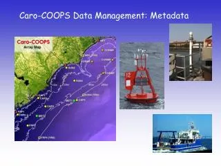
Caro-COOPS Metadata Initiatives • To create a metadata system that will meet the requirements of the FGDC, yet is flexible and efficient. • Utilize other data and metadata standards such as SensorML, MarineXML, and Ecological Metadata Language (EML) • Marine XML: designed to support metadata describing the data collection, quality control and subsequent processing, and facilitate the tracking of regional and global oceanographic data sets (http://www.aodc.gov.au/products/prod/marinexml.html and http://ioc.unesco.org/marinexml/). • SensorML: an XML schema for defining the geometric, dynamic, and observational characteristics of a sensor (rain gauge to a satellite system) (http://vast.uah.edu/SensorML/). • EML: it exists as a set of XML Schema documents that allow for the structural expression of metadata necessary to document a typical data set in the ecological sciences (http://knb.ecoinformatics.org/software/eml/ ).
Caro-COOPS Metadata Initiatives cont. • Metadata archived in relational databases and using XML and XSLT technologies: • Allows for the creation of user templates, only those fields that are regularly updated need to be administered. • Customizable metadata initiatives that are a reflection of the requirements of an individual institution or a researcher. • Always allow for the generation of FGDC metadata to meet federal requirements.
Caro-COOPS Metadata Initiatives cont. • Metadata generated by the Caro-COOPS program is diverse and multiple strategies are needed. • Metadata that describes instrumentation data will require minimum attention once initial metadata documentation has been developed. • Operational metadata will describe geometric, dynamic, and observational characteristics buoy instrumentation (i.e., sensorML). This should only require updates after instrumentation maintenance/calibration. • Biological collections are diverse and require unique solutions that do not necessarily allow for easy automation of metadata procedures.